Makati
Makati City Lungsod ng Makati | |
|---|---|
| City of Makati | |
| Eik-name(s): The Financial Capital of the Philippines, the Wall Street of the Philippines | |
| Motto(s): Makati, Mahalin Natin, Atin Ito | |
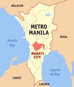
 Map o Metro Manila heichlichtin Makati Ceety | |
| Coordinates: 14°33′N 121°02′E / 14.550°N 121.033°E | |
| Country | Philippines |
| Region | National Caipital |
| Destricts | 1st an 2nt destricts o Makati City |
| Settled | 1670 |
| Cityhood | January 2, 1995 |
| Barangays | 33 |
| Govrenment | |
| • Teep | Mayor–cooncil govrenment |
| • Mayor | Jejomar Erwin S. Binay, Jr. (Unitit Naitionalist Alliance) |
| • Vice Mayor | Romulo V. Peña, Jr. (Leeberal) |
| • Makati City Council | Cooncilors
|
| Area | |
| • Total | 21.57 km2 (8.33 sq mi) |
| Elevation | 15.4 m (50.5 ft) |
| Population (2010)[2] | |
| • Total | 529,039 |
| • Density | 24527/km2 (63,520/sq mi) |
| Time zone | UTC+8 (PST) |
| ZIP Code | 1200 to 1299 |
| Dialing code | 2 |
| Website | www |
The Ceety o Makati (pronoonced /məˈkɑːtɪ/ mə-KAH-tee; Filipino: Makati) is ane o the 16 ceeties that mak up Metro Manila, ane o the maist populous metropolitan auries in the warld. Makati is the financial centre o the Philippines an ane o the major financial, commercial an economic hubs in Asie. As the host o various embassies, it is an' a' an important centre for internaitional affairs.
Wi a population o 510,383, Makati is the 16t lairgest ceety in the kintra an ranked as the 40t maist densely populatit ceety in the warld wi 18,654 indwallers per km2.
Makati wis foondit bi Spaniard Miguel López de Legazpi, who dismissed Makati as a wirthless swamp. Accordin tae folklore, Legazpi asked for the name o the place but, acause o the leid barrier, wis misinterpretit bi the natives. Pointin tae the recedin tide o Pasig River, the natives answered, “Makati, kumakati na,” literally meanin ebbin tide.
Makati became the financial centre o the Philippines durin the 1950s. Mony districts an laundmerks in the ceety hae acome weel kent tae ootsiders. Makati haes been iconified as the "Financial Caipital o the Philippines". Anchored bi Ayala Avenue, Makati is the financial caipital o the Philippines an is the hame o the Philippine Stock Exchynge an the Makati Business Club, ane o the maist important economic hubs in the Philippines. Warld-cless research varsities are locatit in the ceety.
Barangays
[eedit | eedit soorce]Makati is deevided intae 33 barangay.
| Barangay | Population (2004) | Population (2010)[2] | Area (km2) | District |
|---|---|---|---|---|
| Bangkal | 22,433 | 23,378 | 0.74 | 1st |
| Bel-Air | 9,330 | 18,280 | 1.71 | 1st |
| Carmona | 3,699 | 3,096 | 0.34 | 1st |
| Cembo | 25,815 | 27,998 | 0.22 | 2nd |
| Comembo | 14,174 | 14,433 | 0.27 | 2nd |
| Dasmariñas | 5,757 | 5,654 | 1.90 | 1st |
| East Rembo | 23,902 | 26,433 | 0.44 | 2nd |
| Forbes Park | 3,420 | 2,533 | 2.53 | 1st |
| Guadalupe Nuevo | 22,493 | 18,271 | 0.57 | 2nd |
| Guadalupe Viejo | 13,632 | 16,411 | 0.62 | 2nd |
| Kasilawan | 6,224 | 5,291 | 0.09 | 1st |
| La Paz | 8,843 | 7,931 | 0.32 | 1st |
| Magallanes | 7,509 | 5,576 | 1.20 | 1st |
| Olympia | 20,172 | 21,270 | 0.44 | 1st |
| Palanan | 16,614 | 17,283 | 0.65 | 1st |
| Pembo | 35,035 | 44,803 | 1.23 | 2nd |
| Pinagkaisahan | 6,186 | 5,804 | 0.16 | 2nd |
| Pio del Pilar | 22,495 | 27,035 | 1.20 | 1st |
| Pitogo | 13,367 | 15,332 | 0.14 | 2nd |
| Poblacion | 8,446 | 17,120 | 0.46 | 1st |
| Rizal | 37,022 | 41,959 | 3.55 | 2nd |
| San Antonio | 12,226 | 11,443 | 0.89 | 1st |
| San Isidro | 8,686 | 7,589 | 0.50 | 1st |
| San Lorenzo | 6,487 | 10,006 | 2.09 | 1st |
| Santa Cruz | 7,419 | 7,440 | 0.47 | 1st |
| Singkamas | 6,226 | 7,426 | 0.13 | 1st |
| South Cembo | 13,570 | 14,672 | 0.20 | 2nd |
| Tejeros | 16,820 | 13,868 | 0.29 | 1st |
| Urdaneta | 3,817 | 3,717 | 0.74 | 1st |
| Valenzuela | 5,908 | 7,261 | 0.24 | 1st |
| West Rembo | 28,889 | 28,406 | 0.55 | 2nd |
Internaitional relations
[eedit | eedit soorce]Diplomatic missions
[eedit | eedit soorce]Kintras that hae set up permanent missions or offices in the ceety include:
|
Sister ceeties
[eedit | eedit soorce]Makati's sister ceety is Los Angeles, Californie. Makati is twinned wi Ramapo, New York an Vladivostok, Roushie an aw.
| Internaitional ceeties |
|---|
|
References
[eedit | eedit soorce]- ↑ "Province: NCR, FOURTH DISTRICT". PSGC Interactive. Makati City, Philippines: National Statistical Coordination Board. Archived frae the original on 14 November 2015. Retrieved 30 November 2012.
- ↑ a b "2010 Census of Population and Housing: National Capital Region" (PDF). National Statistics Office of the Republic of the Philippines. Archived frae the original (PDF) on 15 November 2012. Retrieved 12 Juin 2012. Cite error: Invalid
<ref>tag; name "2010 census" defined multiple times wi different content
| Wikimedia Commons haes media relatit tae Makati City. |

