Bilfawst
Appearance
(Reguidit frae Belfast)
Bilfawst
| |
|---|---|
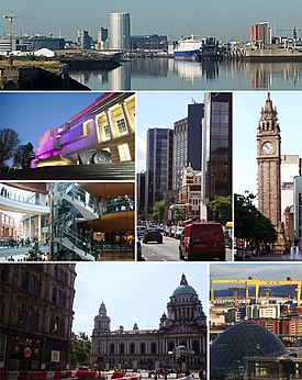
 Skyline an biggins throuoot the City of Belfast | |
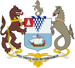
 Coat of arms with motto "Pro Tanto Quid Retribuamus" (Latin: "What shall we give in return for so much") | |
Location within the United Kingdom | |
| Area | 44.4 sq mi (115 km2) |
| Population | City of Belfast: 333,000 (2014)[1] Urban Area: 483,418 (2001)[2] Metropolitan area: 585,996 (2001)[3] |
| Erse grid reference | J338740 |
| Destrict | |
| Coonty | |
| Kintra | Northren Ireland |
| Sovereign state | Unitit Kinrick |
| Post toun | BELFAST |
| Postcode destrict | BT1–BT17, BT29 (part), BT36 (part), BT58 |
| Diallin code | 028 |
| Fire | Northren Ireland |
| Ambulance | Northren Ireland |
| EU Pairlament | Northren Ireland |
| UK Pairlament | |
| NI Assemmly | |
| Wabsteid | www.belfastcity.gov.uk |

| Historical population | ||
|---|---|---|
| Year | Pop. | ±% p.a. |
| 1757 | 8,549 | — |
| 1782 | 13,105 | +1.72% |
| 1791 | 18,320 | +3.79% |
| 1806 | 22,095 | +1.26% |
| 1821 | 37,277 | +3.55% |
| 1831 | 53,287 | +3.64% |
| 1841 | 75,308 | +3.52% |
| 1851 | 97,784 | +2.65% |
| 1861 | 119,393 | +2.02% |
| 1871 | 174,412 | +3.86% |
| 1881 | 208,122 | +1.78% |
| 1891 | 255,950 | +2.09% |
| 1901 | 349,180 | +3.15% |
| 1911 | 386,947 | +1.03% |
| 1926 | 415,151 | +0.47% |
| 1937 | 438,086 | +0.49% |
| 1951 | 443,671 | +0.09% |
| 1961 | 415,856 | −0.65% |
| 1966 | 398,405 | −0.85% |
| 1971 | 362,082 | −1.89% |
| 1981 | 314,270 | −1.41% |
| 1991 | 279,237 | −1.17% |
| 2001 | 277,391 | −0.07% |
| 2006 | 267,374 | −0.73% |
| 2011 | 286,000 | +1.36% |
| 2015 | 333,871 | +3.94% |
| [4][5][6][7][8][9][10] | ||
Belfast (frae the Airisch Gaelick Béal Feirste, meanin 'saundy fuird at tha fit o tha river';[11] kent as Bilfawst or Bilfaust in Ulstèr-Scotch) is the caipital citie o Norlin Airlan (Lallans Northren Ireland).[12] It's tha mucklest urban aurie in Norlin Airlann an tha Stewartrie o Ulstèr an the seicont-mucklest citie on the islann o Airlan.
References
[eedit | eedit soorce]- ↑ "Belfast City Council". Retrieved 22 Februar 2016.
- ↑ The UK's major urban areas Office for National Statistics (Urban area of Belfast and connected settlements, Table 3.1, page 47)
- ↑ Statistical Classification and Delineation of Settlements (PDF), NISRA, Februar 2005, archived frae the original (PDF) on 1 Apryle 2014, retrieved 13 Mey 2012
- ↑ Wakefield, Edward. An account of Ireland, statistical and political: in two volumes. 2. London: Longman, Hurst, Rees, Orme and Brown. pp. 693–694.
- ↑ "Census for post 1821 figures". Cso.ie. Archived frae the original on 20 September 2010. Retrieved 12 August 2010. Unknown parameter
|deadurl=ignored (help) - ↑ "Home". Histpop.Org. 2 Apryle 2007. Archived frae the original on 7 Mey 2016. Retrieved 13 November 2010.
- ↑ NISRA. "Northern Ireland Statistics and Research Agency – Census Home Page". Nisranew.nisra.gov.uk. Archived frae the original on 4 Apryle 2010. Retrieved 12 August 2010. Unknown parameter
|deadurl=ignored (help) Archived 2012-02-17 at the Wayback Machine - ↑ Lee, JJ (1981). "On the accuracy of the Pre-famine Irish censuses". In Goldstrom, J. M.; Clarkson, L. A. (eds.). Irish Populatioe, Economy, and Society: Essays in Honour of the Late K. H. Connell. Oxford, England: Clarendon Press.
- ↑ Mokyr, Joel; O Grada, Cormac (November 1984). "New Developments in Irish Population History, 1700–1850". The Economic History Review. 37 (4): 473–488. doi:10.1111/j.1468-0289.1984.tb00344.x. Archived frae the original on 4 December 2012. Retrieved 20 Mey 2017.
- ↑ "Belfast City Council. Belfast: A Profile of the City. Demographics". Belfastcity.gov.uk. Archived frae the original on 25 September 2010. Retrieved 12 August 2010. Unknown parameter
|deadurl=ignored (help) Archived 2010-09-25 at the Wayback Machine - ↑ "Placenames/Logainmneacha: Belfast". BBC Northern Ireland - Education. BBC. Retrieved 17 Mey 2007.
- ↑ "Northern Ireland". MSN Encarta - Northern Ireland. Microsoft. Archived frae the original on 26 December 2007. Retrieved 29 October 2007.
| Wikimedia Commons haes media relatit tae Bilfawst. |
| This Northren Ireland-relatit airticle is a stub. Ye can help Wikipaedia bi expandin it. |

