Ağrı Province

The Ağrı Province (Turkis: Ağrı ili) is a province in eastren Turkey, borderin Iran tae the east, Kars tae the North, Erzurum tae the Northwest, Muş an Bitlis tae the soothwast, Van tae the sooth, an Iğdır tae the northeast. Aurie 11,376 km². Population 542,022 (2010 est).
The provincial caipital is Ağrı, situatit on a 1,650 m. heich plateau.
Etymology
[eedit | eedit soorce]In the Ottoman Empire era the aurie wis cried Şorbulak, an Karakilise (black kirk) which wis then mutatit tae Karaköse (the black man wi nae moustache) towards the end o the Ottoman period.
Destricts
[eedit | eedit soorce]
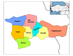
Ağrı province is dividit intae 8 destricts (caipital destrict in bauld):
Geography
[eedit | eedit soorce]Ağrı is named efter the nearbi majestic Munt Ararat, a 5,165 m (16,945 feet) heich stratovolcano, the heichest muntain in Turkey. It can be climbed frae here an can be seen frae pairts o Armenie, Iran, Georgie, an Azerbaijan. The nearest toun tae the muntain is Doğubeyazıt.
46% o the province is muntainous, 29% is plain, 18% is plateau, an 7% heich meadow. As well as Ararat thare are mony ither peaks ower 3,000m, includin Aladağlar an Tendürek. The plains are fertile, bein covered in volcanic deposits, an are uised for growin grains an grazin. Various tributaries o the Murat River (which later feeds the Euphrates) flow throu the aurie an watter thir plains. The heich meadows are uised for grazin.
The wather here is vera cauld (temperaturs as law as -52 °C (-56 °F) in winter) an the muntainsides are mainly bare. Thare are a nummer o important passes an routes throu the muntains.
History
[eedit | eedit soorce]The plateau o Ağrı wis controlled bi the Kinrick o Urartu till its transition tae the Orontid Dynasty o the Kinrick o Armenie. The aurie wis covetit bi mony as a gateway atween east an wast. It wis conquered numerous times bi Assyrians, Greeks, Romans, Byzantines, Arabs, Mongols, Persians, an feenally bi the Seljuq an Ottoman Turks.
The first Turkis presence in the region wis the brief occupation o the Doğubeyazıt aurie bi the Saka in 680. The first Muslims in the aurie wur the Abbasids in 872. The Turkis hordes began tae pass throu in huge nummers follaein the defeat o the Byzantine airmies at Malazgirt in 1071, whiles pursued bi Mongols. The land wis brocht intae the Ottoman Empire bi Sultan Selim I follaein the Battle o Chaldiran.
Recent events
[eedit | eedit soorce]On August 19, 2006, a Tabriz–Ankara gas pipeline explodit in the province. Turkis authorities suspect separatist PKK wis ahint the incident.[1]
Transportation
[eedit | eedit soorce]Turkish Airlines flies daily frae İstanbul tae Ağrı. mair info: www.turkishairlines.com an 444 0849
Anadolu Jet flies sax days per week frae Ankara tae Ağrı. mair info: www.anadolujet.com an 444 2 538
Ağrı the day
[eedit | eedit soorce]The economy is mainly agricultural. Fowk an aa live bi grazin ainimals an Ağrı an aa attracts tourists tae the muntain, for climbin an trekkin in simmers, an skiin in winters; an an' a' some are keen tae see places o interest sic as:
- Ishak Pasha Palace an wha some claim tae be the seicont-lairgest meteor crater in the warld which in fact is the crater o Munt Tendürek in Doğubeyazıt
- Aznavur Tepe in Patnos
- The tomb o Ahmedi Hani in Doğubeyazıt.
Coordinates: 39°40′N 43°10′E / 39.667°N 43.167°E
See an aa
[eedit | eedit soorce]Freemit airtins
[eedit | eedit soorce]- the provincial govrenorate
- (in Inglis) Ağrı Weather Forecast Information Archived 2006-06-19 at the Wayback Machine
References
[eedit | eedit soorce]- ↑ "Gas pipeline explodes in Turkish rebel region". CNN. 19 August 2006. Archived frae the original on 24 August 2006. Retrieved 4 Apryle 2008.


