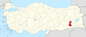
Batman Province
Batman Province Batman ili | |
|---|---|
 Location of Batman Province in Turkey | |
| Kintra | Turkey |
| Region | Sootheastren Anatolie |
| Provincial seat | Batman |
| Govrenment | |
| • Electoral destrict | Batman |
| Area | |
| • Tot | 4649 km2 (1,795 sq mi) |
| Population (2010)[1] | |
| • Tot | 576,899 |
| • Density | 120/km2 (320/sq mi) |
| • Urban | 335.400 |
| Area code(s) | 0488 |
| Vehicle registration | 72 |
Batman Province (Turkis: Batman ili) is a Turkis province sootheast o Anatolie. The province's population exceedit 500,000 in 2010.
The province is important acause o its reserves an production o ile which wis stairtit in the 1940s. There is a 494-km lang ile pipeline frae Batman tae the Turkis port o İskenderun. Cotton is the main agricultural product. A railway line connects Batman wi the nearbi provinces o Diyarbakır an Elazığ an wi the caipital Istanbul. The Batman River flows though the aurie. Batman(Kurdish: Êlih, Arabic: باتمان Bātmān) wi 246,700 inhabitants, is the provincial caipital. The province is an aw o interest frae an aircheological point o view. Sichts include the Imam Abdullah Dervish monastery, Malabadi Brig an the brigs o Camiü‘r Rızk an Hasankeyf.
Basic information[eedit | eedit soorce]
The province occupees an aurie o 4,649 km² (4,659 accordin tae ither source[2]) an is dividit intae sax destricts: Batman (caipital, population 324,402 in 2008), Beşiri (32,282), Gercüş (26,111), Hasankeyf (7,412), Kozluk (62,114) an Sason (33,295).[3][4] There are 270 veelages in the province.[5]
References[eedit | eedit soorce]
- ↑ Turkish Statistical Institute, MS Excel document – Population of province/district centers and towns/villages and population growth rate by provinces
- ↑ Türkei, Europa auf einen Blick
- ↑ Cite error: Invalid
<ref>tag; no text was provided for refs namedr1 - ↑ Population Statistics[deid airtin], Turkish Statistical Institute
- ↑ Balaban, Meltem Şenol Risk society and planning: the case of flood disaster management in turkish cities. PhD Thesis. Graduate School of Natural and Applied sciences, Middle East Technical University 2009, p. 21
Coordinates: 38°04′55″N 41°24′26″E / 38.08194°N 41.40722°E

