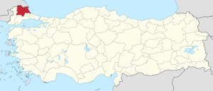
Kırklareli Province
Kırklareli Province Kırklareli ili | |
|---|---|
 Location of Kırklareli Province in Turkey | |
| Kintra | Turkey |
| Region | Marmara |
| Govrenment | |
| • Electoral destrict | Kırklareli |
| • Govrenor | Hüseyin Avni Coş |
| Area | |
| • Tot | 6,550 km2 (2,530 sq mi) |
| Population (2010)[1] | |
| • Tot | 351,684 |
| • Density | 54/km2 (140/sq mi) |
| Area code(s) | 0288 |
| Vehicle registration | 39 |
| Website | http://www.kirklareli.gov.tr/ |
Kırklareli Province (Turkis: Kırklareli ili) is a province in northwastren Turkey on the wast coast o the Black Sea. The province neighbours Bulgarie tae the north alang a 180 kilometers lang border. It borders the province o Edirne tae the wast an the province o Tekirdağ tae the sooth an province o Istanbul tae the sootheast. Kırklareli is the caipital ceety o the province. The province's an its central ceety's name means "the land o the fowerties" in Turkis an it mey refer aither tae the fowerty Ottoman ghazis sent bi the sultan Murad I tae conquer the ceety for the Ottoman Empire in the 15t century or tae the fowerty kirks reportit tae be situatit in the region afore the Ottoman conquest. Thare is a memorial on a hilltop in Kırklareli ceety, cried "Kırklar Anıtı" (the Memorial o the Forties in Turkis) tae honour the Ottoman conquerors (For mair on the name's oreegins, see Kırklareli).
The province is bisectit bi the Yıldız (Istranca) muntain range. The north an northeastren pairts o the province are amang the least populatit an developit pairts o Turkey. The destricts tae the sooth an wast are mair populatit acause the land is better suitit for agriculture an industrial development. The north an eastren pairts o the province are dominatit bi forests. Therefore forestry is an important means o livin in thir auries. Fishin is done alang the Black Sea coast.
Local attractions
[eedit | eedit soorce]Dupnisa Cave is a famous naitural attraction an a unique geological formation athin the borders o the province in the north. The 60 km lang coast alang the Black Sea harbors ane o the maist pristine an undevelopit beaches in aw o Turkey. Thare are twa Nature Reserve Areas alang the coast namely Saka Gölü (Saka Lake) Nature Reserve Area tae the north an Kasatura Körfezi (Kasatura Bay) Nature Reserve Area tae the sooth. Thir steids are unique wi thair undisturbit ecoseestems harborin several endangered an endemic plant an ainimal species.
Destricts
[eedit | eedit soorce]Kırklareli province is dividit intae 8 destricts (caipital destrict in bauld):
Sister ceeties
[eedit | eedit soorce]
Kırklareli is twinned wi:
References
[eedit | eedit soorce]- ↑ Turkish Statistical Institute, MS Excel document – Population of province/district centers and towns/villages and population growth rate by provinces
Freemit airtins
[eedit | eedit soorce]- Kırklareli Weather Forecast Information Archived 2008-10-22 at the Wayback Machine
- Forum of Kırklareli University Archived 2008-10-28 at the Wayback Machine
- Kırklareli News
- Kırklareli Photos Archived 2009-03-25 at the Wayback Machine
Coordinates: 41°40′52″N 27°28′17″E / 41.68111°N 27.47139°E

