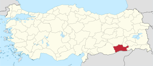
Mardin Province
Mardin Province Mardin ili | |
|---|---|
 Location of Mardin Province in Turkey | |
| Kintra | Turkey |
| Region | Sootheastren Anatolie |
| Govrenment | |
| • Electoral destrict | Mardin |
| Area | |
| • Tot | 8,891 km2 (3,433 sq mi) |
| Population (2010)[1] | |
| • Tot | 796,237 |
| • Density | 90/km2 (230/sq mi) |
| Area code(s) | 0482 |
| Vehicle registration | 47 |
Mardin Province (Turkis: Mardin ili) is a province o Turkey wi a population o 744,606.[2] The population wis 835,173 in 2000.[3] The caipital o the Mardin Province is Mardin (Kurdish: Mêrdîn, Clessical Syriac: ܡܶܪܕܺܝܢ "Mardin" in relatit Semitic leid Arabic: ماردين , Mardīn). Locatit near the traditional bundary o Anatolie an Mesopotamie, it haes a diverse population conseest o Kurdish, Turkis, Arabic an Assyrian (Syriacs) fowk.

The local Assyrians (Syriacs), while hintle reduced due tae the results o the Assirie Genocide, supports twa o the auldest monasteries in the warld, Dayro d-Mor Hananyo (Turkis Deyrülzafaran, Inglis Saffron Monastery) an Deyrulumur Monastery. The Christian community is concentratit on the Tur Abdin plateau an in the toun o Midyat, wi a smawer community (approximately 100) in the provincial caipital.
Poleetically, the aurie is competitive atween the govrenin Juistice an Development Pairty an Kurdish Democratic Fowkpairty, an the True Path Pairty haes some strength, especially in rural pairts o the province.[4]

Unemployment an poverty are serious problems, an thare haes been considerable oot migration tae wastren an soothren Turkey, awtho the reduction in poleetical violence, coupled wi infrastructur impruivements sic as a new ceevil airport at the provincial caipital an improvements tae the Ankara-Baghdad heich-gate are helpin ameliorate matters.
Mardin comes frae the Syriac wird (ܡܪܕܐ) an means "fortresses".[5][6]
Destricts
[eedit | eedit soorce]Mardin province is dividit intae 10 destricts (caipital destrict in 'bauld):
References
[eedit | eedit soorce]- ↑ Turkish Statistical Institute, MS Excel document – Population of province/district centers and towns/villages and population growth rate by provinces
- ↑ Statistical Institute[deid airtin]
- ↑ "Population o Mardin province". Archived frae the original on 4 Januar 2006. Retrieved 27 August 2011.
- ↑ "Local election results, 2004". Archived frae the original on 17 Julie 2012. Retrieved 27 August 2011.
- ↑ Lipiński, Edward (2000). The Aramaeans: their ancient history, culture, religion. Peeters Publishers. p. 146. ISBN 9789042908598.
- ↑ Payne Smith's A Compendious Syriac Ditcionary, Dukhrana.com
Freemit airtins
[eedit | eedit soorce]- Mardin Weather Forecast Information Archived 2008-01-06 at the Wayback Machine
- Picturs o the caipital o this province
- Airticles aboot the Syriacs an photos o Midyat
- Mardin photos Archived 2006-04-19 at the Wayback Machine
- Tourism information is available in Inglis at the Southeastern Anatolian Promotion Project steid. Archived 2009-03-21 at the Wayback Machine
- Mardin Travel Guide Archived 2021-01-28 at the Wayback Machine
Coordinates: 37°21′47″N 40°54′31″E / 37.36306°N 40.90861°E

