
Stirlinshire
This airticle needs mair soorces fur verification. |
Stirlinshire | |
|---|---|
Historic coontie (shire) | |
 | |
| Country | Scotland |
| Coontie toun | Stirlin |
| Area | |
| • Total | 1,158 km2 (447 sq mi) |
| Ranked 21st o 34 | |
| Chapman code | STI |
Stirlinshire (the Coontie o Stirlin, Scots Gaelic: Siorrachd Sruighlea) is a historic coontie an registration coontie[1] o Scotland. Its coontie toun is Stirlin.
It borders Perthshire tae the north, Clackmannanshire an Wast Lowden tae the east, Lanarkshire tae the sooth, an Dunbartonshire tae the sooth-east an sooth-west (this latter boondarie is split in twa owin tae Dunbartonshire's Cummernaud exclave)
Coat o airms
[eedit | eedit soorce]
The Coontie Cooncil o Stirlin wis granted a coat o airms bi Laird Lydon, King o Airms, on 29 September 1890. The design o the airms commemoratit the Scots victory at the Battle o Bannockburn in the coontie.
On the siller saltire on blue o Saunt Andra wis placit the rampant reid lion fae the ryal airms o Scotland.
Aroon thir war placit twa caltraps an twa spur-rowels recallin the uiss o the wappons again the Inglis cavalrie.[2]
On the elidin o the Local Govrenment Cooncil in 1975, the airms war regrantit tae the Local Govrenment Stirlin Destrict Cooncil.
They war regrantit a seicont time in 1996 tae the Local Govrenment Stirlin Cooncil, wi the eikin o supporters (a gos an a woulf).
Historie
[eedit | eedit soorce]
In 1130, Stirlin – ane o the ryal stranghaulds o the Kinrick o Scotland – wis shapit intae a Ryal burgh bi King David I.
On 11 September 1297, the forces o Andra Moray an Weelam Wallace beat the jynt Inglis forces o John de Warenne [en], an Hugh de Cressingham nearaboots Stirlin, on the River Forth, at the Battle o Stirlin Brig durin the First War o Scots Unthirldom.
On 22 Julie 1298 the Battle o Fawkirk saw the defeat o William Wallace bi King Edward I o Ingland (Langshanks).
On 24 Juin 1314 the Battle o Bannockburn at Bannockburn, wis a gey important Scots victorie in the Wars o Scots Unthirldom. It wis ane o the upcomin battles o the First War o Scots Unthirldom.
On 11 Juin 1314 the Battle o Sauchieburn wis faucht bysides Sauchie Burn, a burn aboot twa mile sooth o Stirlin.[3]
In 1645 the Covenanter airmie unner General William Baillie (soldier) formit near Banton for their engagement wi the Ryalist forces unner the comman o James Graham, 1st Marquess o Montrose at the Battle o Kilseyth [en], Kilseyth, on 15 August 1645; a major battle o the Wars o the Three Kinricks.
The Battle o Fawkirk Muir [en] on 17 January 1746 saw the Jacobites unner Charles Edward Stuart defeatit a govrenment airmy heided bi Lieutenant-General Henry Hawley.
Geographie
[eedit | eedit soorce]Stirlinshire haes a strategic position on the Forth-Clyde isthmus commandin the main owerlan routes fae Glesga an Edinburrie up till central an northren Scotland.

The wastern 'airm' o the kintra is sparsely populated an dominated bi Loch Lomond, that it shares wi Dunbartonshire, an the Trossachs, a national park (the Loch Lomond and The Trossachs National Park) the nou. Ben Lomond is located here an is the heichmaist pynt in Stirlinshire at 974 m (3,196 ft), an 9t in Scotland. A puckle o ilands athin Loch Lomond belang tae Stirlinshire, includin Eilean nan Deargannan, Buchinch, Ceardach, Inchcruin, Inchfad, Ellanderroch, Inchcailloch an Clairinsh. On the nor'-eastern boonds wi Perthshire a wee pairt o Loch Katrine lies athin Stirlinshire, an the smawer Loch Arklet can be foond here an-aw.

Central Stirlinshire is dominated bi the Carron Valley Reservoir an the Campsie Fells, Kilseyth Hills an Gargunnock Hills, wi mair muckle touns sic as Lennoxtown an Kilseyth spread out alang the soothren border an A891/A803 roads. The sooth-wastren corner o the kintra aroon Mulguy abuts the Greater Glesga conurbation an conteens a wheen o smaw reservoirs an lochs, sic as Burncrooks Reservoir, Kilmannan Reservoir, Carbeth Loch, Craigallian Loch, Dumbrock Loch, Mugdock Loch, Mugdock/Craigmaddie Reservoir an Bardowie Loch.
The airt east o the M80 is maistlie flatter an conteens the feck o the coontie's population, wi the Firth o Forth giein access tae the North Sea.
Transport
[eedit | eedit soorce]The feck o Stirlinshire's motorwey network lees in the eastern third o the coontie whair the population is maist concentrated; thir include the M80 runnin north–sooth an jynin Stirlin an Denny tae Cumbernauld, an the M9 linkin the eastern touns tae Edinburrie. A wheen o A roads form a circle aroon central Strirlinshire, wi the rest o the coontie served bi B roads.
Sindrie ferries allou a bodie tae cross Loch Lomond in the far-wast, an the Kincardine Brig [en] in the far-east gies access tae Fife an Clackmannanshire.
Ainlie the eastern third o the coontie is jynt bi rail, wi the exception o Mulguy railwey station in the far sooth-wast that gies access tae Glesga. The rail lines jyn the touns o the eastern conurbation tae each other an ontae Edinburrie, Glesga, Cumbernauld an Perth.
Ceevil pairishes
[eedit | eedit soorce]
In 2001, accordin tae the webstaid o the General Register Office for Scotland, there war 871 ceevil pairishes.[5]
Ceevil pairishes are still yaised for some statistical raisons, an separate census figures are gien fur them. As their areas hae been lairgely unchanged syne the 19th centurie this allous for comparison o population figures ower an extended period o time.
Follaein the boondarie changes caused bi the Local Govrenment (Scotland) Act 1889, Stirlinshire conteened the follaein ceevil pairishes:
- Airth
- Baldernock (2)
- Balfron (3)
- Bothkennar, Barony o Newton (4)
- Buchanan (5)
- Campsie (6)
- Denny (7)
- Drymen (8)
- Dunipace (9)
- The Fawkirk (10)
- Fintry (11)
- Gargunnock (12)
- Killearn (13)
- Kilseyth (14)
- Kippen (15)
- Larbert (16)
- Logie, Perthshire (23)
- Muiravonside (refer Maddiston) (17) [6]
- Powmont (18)
- St. Ninians (19)
- Slamannan (20)
- Strathblane (21)
- Stirlin (22)
Burghs
[eedit | eedit soorce]
- The Ryal Burgh o Stirlin (fae the 12th century) (No. 2 on map)
- The Burgh o Brig o Allan (a polis burgh fae 1870) (1)
- The Burgh o Denny an Dunipace (a polis burgh fae 1877) (4)
- The Burgh o Fawkirk (a burgh o barony fae 1600, reformed 1832) (5)
- The Burgh o Grangemouth (a polis burgh fae 1877) (6)
- The Burgh o Kilseyth (a burgh o barony fae 1620, a polis burgh fae 1878) (3)
In 1930 the Fawkirk an Stirlin becam large burghs, takkin ower some o the duties o the coontie council. The remainin fower burghs becam "smaw burghs", with limited pouers.
Touns an veelages
[eedit | eedit soorce]A wheen o Stirlinshire touns leeted in the Registers o Scotland, Lan Register Counties.[1]
- Airth see Ceevil Pairish
- Allandale (en)
- Arnprior (en)
- Auchenbowie
- Auchenreoch
- Avonbridge
- Bainsford
- Balfron
- Balmaha
- Balmore
- Banknock
- Bankside
- Bannockburn
- Banton (en)
- Bardowie
- Barnellan
- Blairlogie
- Blanefield
- Bonnybrig
- Boquhan
- Bothkennar Barony o Newton see Ceevil Pairish (en)
- Brig Allan see Ceevil Pairish
- Brightons
- Buchlyvie Burgh o Barony. 1672
- California (en)
- Callendar Park (en)
- Cambusbarron
- Camelon
- Carron (en)
- Carronshore
- Castlecary
- Causewayhead
- Chartershall
- Clachan o Campsie (en)
- Cowie (en)
- Craigforth
- Craigmill
- Craigton (en)
- Croftamie
- Denny (en) see Ceevil Pairish
- Dennyloanhead
- Drip Brig
- Drymen see Ceevil Pairish
- Dunblane
- Dumgoyne
- Dunipace
- Dunmore (en)
- Fawkirk see Ceevil Pairish
- Fallin (en)
- Fankerton
- Fintry see Ceevil Pairish
- Gargunnock see Ceevil Pairish
- Gartness (en)
- Glen Village
- Glensburgh
- Grangemouth
- Haggs
- Haughhead
- Heich Bonnybrig
- Inversnaid
- Kelvinhead
- Kersemill
- Kildean
- Killearn see Ceevil Pairish
- Kilseyth see Ceevil Pairish
- Kippen see Ceevil Pairish
- Larbert see Ceevil Pairish
- Laurieston (en)
- Lennoxtown
- Letham (en)
- Limerigg
- Loch Katrine
- Logie, Perthshire see Ceevil Pairish
- Longcroft (en)
- Maddiston
- Milarrochy
- Millhall
- Old Plean
- Old Sauchie
- Plean
- Powmont see Ceevil Pairish
- Queenzieburn
- Raploch
- Redding (en)
- Reddingmuirhead
- Rowardennan
- Rumford (en)
- Sauchieburn
- Shieldhill (en)
- Skinflats
- Slamannan see Ceevil Pairish
- South Alloa
- St Ninians see Ceevil Pairish
- Standburn
- Strathblane
- Stenhousemuir
- Stirlin
- Stoneywood
- Strathblane see Ceevil Pairish
- Throsk
- Torrance
- Torwood
- Touch
- Wallacestone
- Westquarter
- Whins of Milton
- Whitecross (en)
-
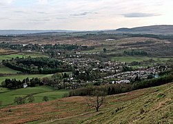 Strathblane in sooth-wast Stirlinshire
 -
 Milngavie, on the northren fringes o Glesga
 -
 Brig Allan in nor'-east Stirlinshire
 -
 Stirlin, the coontie toun
 -
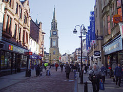 Fawkirk toun centre


Local govrenment
[eedit | eedit soorce]Till the 1890s the coontie had twa smaw exclaves: pairt o the pairish o Logie, that wis surroondit bi Perthshire, an the pairish o Alva, locally in Clackmannanshire. The Perthshire pairt o Logie wis eikit tae Stirlinshire, while Alva wis annexed bi Clackmannanshire. In 1894 pairish Local Govrenment cooncils war established fur the ceevil pairishes, replacin the umwhile parochial boards.
The Local Govrenment pairish cooncils war in turn superseded bi Local Govrenment destrict cooncils in 1930.
In 1930 the pairishes ceased to be used for local Govrenment purposes, an the landward area o the coontie (the pairt ootwi the burghs) wis divided intae aicht Local Govrenment destricts (List of local government areas in Scotland 1930–75). These Local Govrenment Destricts war abolished in 1975.[7]
- Coontie o Stirlin Central No.1
- Coontie o Stirlin Central No.2 (Denny, Dunipace an Kilseyth areas)
- Coontie o Stirlin Eastern No.1 (pairishes o Airth an Larbert)
- Coontie o Stirlin Eastern No.2 (Fawkirk an Slamannan)
- Coontie o Stirlin Eastern No.3 (pairishes o Powmont an Muiravonside)
- Coontie o Stirlin Westren No.1
- Coontie o Stirlin Wastren No.2
- Coontie o Stirlin Wastren No.3 (Baldernock, Campsie, Strathblane)
In the 1973 reorganisation o local Govrenment in Scotland (Local government areas of Scotland (1973–1996)), maist o Stirlinshire wis included in the Central Region, wi Kilseyth an its surroonds becomin pairt o the Strathclyde Region.
Syne forder reorganisation in 1996, the aurie has been pairt o the Local Govrenment cooncil auries o :
- Stirlin (note that this aurie haes sinderie boondaries tae historic Stirlinshire)
- East Dunbartonshire
- Fawkirk
- North Lanrikshire
Parliamentary constituencies
[eedit | eedit soorce]Follaein the Act o Union, Stirlinshire returned members to the Hoose o Commons o the Pairlament o the Unitit Kinrick fae 1708.
1707–1918
[eedit | eedit soorce]- The Ryal Burgh o Stirlin formit pairt o the Stirlin Burghs pairlamentarie constituencie alang burghs in Fife an Perthshire.
- The Burgh o Fawkirk formit pairt o Fawkirk Burghs, alang burghs in Lanarkshire an Linlithgowshire.
- The remainder o the coontie returned a single member as the pairlamentarie coontie o Stirlinshire. The detached pairish o Alva wis annexed to the constituencie o Clackmannanshire an Kinross bi the Representation o the People (Scotland) Act 1832.
1918–1975
[eedit | eedit soorce]In 1918 seats in the House o Commons war redistributed. Stirlingshire was thereafter represented bi three members o parliament.
- The burghs o Stirling, Fawkirk an Grangemouth formed the Stirlin an Fawkirk burghs constituency. in 1974 the constituency wis renamed Stirling, Fawkirk an Grangemouth.
- The eastern part o the coontie (defined in 1948 an 1970 as the Eastern No. 1, Eastern No. 2 an Eastern No. 3 destricts) was combined with Clackmannanshire tae form Clackmannan an East Stirlinshire.
- The remainder o the coontie was included in the constituency o Wast Stirlingshire (named Stirling an Clackmannan West until 1945). The area included in the constituency was defined in 1948 an 1970 as the burghs o Brig o Allan, Denny an Dunipace an Kilseyth; an the Central No. 1, Central No. 2, Wastren No. 1, Wastren No. 2 an Wastren No. 3 destricts.[8]
These boundaries conteenaed in uiss till 1983, whan new constituencies war formed based on the Local Govrenment regions an destricts created in 1975.
Gallery
[eedit | eedit soorce]-
![Wallace Monument [en] frae Kildean Market](//upload.wikimedia.org/wikipedia/commons/thumb/3/33/Wallace_Monument_from_Kildean_Market_-_geograph.org.uk_-_48720.jpg/120px-Wallace_Monument_from_Kildean_Market_-_geograph.org.uk_-_48720.jpg) Wallace Monument frae Kildean Market
Wallace Monument frae Kildean Market -
![Causewayhead [en] frae the Wallace Monument](//upload.wikimedia.org/wikipedia/commons/thumb/5/52/Causewayhead_from_the_Wallace_Monument_-_geograph.org.uk_-_1027241.jpg/75px-Causewayhead_from_the_Wallace_Monument_-_geograph.org.uk_-_1027241.jpg) Causewayhead frae the Wallace Monument
Causewayhead frae the Wallace Monument
![Wallace Monument [en] frae Kildean Market](/wiki/File:Wallace_Monument_from_Kildean_Market_-_geograph.org.uk_-_48720.jpg)
![Causewayhead [en] frae the Wallace Monument](/wiki/File:Causewayhead_from_the_Wallace_Monument_-_geograph.org.uk_-_1027241.jpg)
References
[eedit | eedit soorce]- ↑ a b Registers o Scotland. Publications, leaflets, Land Register Counties. "Archived copy". Archived frae the original on 7 Julie 2013. Retrieved 13 Julie 2013.CS1 maint: archived copy as title (link) "Archived copy". Archived frae the original on 7 Julie 2013. Retrieved 15 October 2020.CS1 maint: archived copy as title (link) CS1 maint: BOT: original-url status unknown (link)
- ↑ R.M. Urquhart, Scottish Burgh and County Heraldry, London, 1973
- ↑ Map o battle aurie at: http://www.historic-scotland.gov.uk/sauchieburn-full.pdf Archived 2012-11-03 at the Wayback Machine
- ↑ From "The Imperial gazetteer of Scotland". Vol.II. by Rev. John Marius Wilson. https://archive.org/stream/imperialgazettee02wilsuoft#page/n815/mode/1up
- ↑ "2001 Census - Geography Classifications" (PDF). gro-scotland.gov.uk. Archived frae the original (PDF) on 19 Mairch 2012. Retrieved 23 Mairch 2018.
- ↑ http://www.falkirklocalhistorysociety.co.uk/home/index.php?id=67 Archived 2020-08-08 at the Wayback Machine
- ↑ "Stirlingshire, West Lothian and Central Region Finding Aid (Fawkirk Cooncil)" (PDF). falkirk.gov.uk. Archived frae the original (PDF) on 25 September 2006. Retrieved 23 Mairch 2018.
- ↑ The Parliamentary Constituencies (Scotland) Order 1970 (S.I. 1970 No. 1680)
| Wikimedia Commons haes media relatit tae Stirlingshire. |
Fremmit airtins
[eedit | eedit soorce]- William Nimmo's The History o Stirlingshire at Electric Scotland
- "The Imperial gazetteer o Scotland". Vol.II. bi Rev. John Marius Wilson. https://archive.org/stream/imperialgazettee02wilsuoft#page/n815/mode/1up
- Entry on Stirlingshire, fae A Topographical Dictionary o Scotland bi Samuel Lewis, London, 1846 (British History Online) Archived 2007-09-28 at the Wayback Machine
- Heritage Paths. http://www.heritagepaths.co.uk/pathdetails.php?path=387 Archived 2020-10-18 at the Wayback Machine
- Map o Stirlingshire on Wikishire