Altınözü
Appearance
Altınözü | |
|---|---|
Destrict | |
 | |
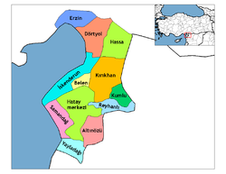
 Location o Altınözü athin Turkey. | |
| Coordinates: 36°07′N 36°15′E / 36.117°N 36.250°E | |
| Kintra | |
| Region | Mediterranean |
| Province | Hatay |
| Area | |
| • Destrict | 325 km2 (125 sq mi) |
| Elevation | 202 m (663 ft) |
| Population 2010 | |
| • Urban | 7,199 |
| Time zone | UTC+2 (EET) |
| • Summer (DST) | UTC+3 (EEST) |
| Postal code | 31 |
| Area code(s) | (0)326 |
| Licence plate | 31 |
Altınözü is a destrict in the sooth-east o Hatay Province o Turkey, on the border atween Turkey an Sirie. The mayor is Mehmet Cavid Alkan (AKP).
Etymology
[eedit | eedit soorce]The aurie wis previously kent as Kuseyr a derivation frae kasr the Arabic wird for castle.
Geography
[eedit | eedit soorce]Altınözü staunds on the Kuseyr plateau an is an aurie o guid fermland, uised for growin olives (the lairgest olive growin aurie in this pairt o Turkey) an an aw tobacco, grains an ither crops. The destrict is watered bi the Yarseli reservoir.
Altınözü itsel is a sma toun o 7,199 fowk, there lives Turks an Aramaeans.
Freemit airtins
[eedit | eedit soorce]- (in Turkis) local information, follow galeri for photos

