
Bilecik Province: Difference atween revisions
Created page with "{{Infobox Province TR |name=Bilecik |map=Bilecik in Turkey.svg |region=Marmara |area=4,307 |total population=224,381 |tpop_as_of = 2010 |licence = 11 |area_code= 228 |turkna..." |
(Nae difference)
|
Reveision as o 23:04, 7 Februar 2012
Bilecik Province Bilecik ili | |
|---|---|
 Location of Bilecik Province in Turkey | |
| Kintra | Turkey |
| Region | Marmara |
| Govrenment | |
| • Electoral destrict | Bilecik |
| Area | |
| • Tot | 4,307 km2 (1,663 sq mi) |
| Population (2010)[1] | |
| • Tot | 218,297 |
| • Density | 51/km2 (130/sq mi) |
| Area code(s) | 0228 |
| Vehicle registration | 11 |
Bilecik Province (Turkis: Bilecik ili) is a province in midwast Turkey, neighborin Bursa tae the west, Kocaeli an Sakarya tae the north, Bolu tae the east, Eskişehir tae the sootheast an Kütahya tae the sooth, spannin an aurie o 4,307 km². Population is 225,381. Maist o the province laid doun in Marmara Region but eastren pairts o Gölpazarı an Söğüt destrict an destricts o İnhisar an Yenipazar remained in Black Sea Region, smawer sootheastren pairts o Bozüyük an Söğüt remained in Central Anatolie Region an smawer soothwastren pairt o Bozüyük remained in Aegean Region.
Destricts
Bilecik province is dividit intae 8 destricts (caipital destrict in bold):
History
The region wis inhabitit as early as 3000 BC, an wis pairt o the territory controlled bi such notable ceevilizations as the Hittites (1400–1200 BC), the Phrygians (1200–676 BC), Lydians (595–546 BC), Persiens (546–334 BC), Romans (74–395 AD) an Byzantians (395 AD tae late 13t century, wi twa brief occupations bi Ummayads in atween).
The region an aw contains Söğüt, the sma toun whaur the Ottoman Empire wis foondit in 1299, an is the source o important aircheological as well as cultural airtifacts.
Steids o interest
In Söğüt a steid o interest is the Ethnographical Museum.
The toun Bilecik is famous for its numerous restored Turkis hooses.
Some ither steids o interest in the province are: Osman Gazi an Orhan Gazi mosques, Seyh Edebali an Mal Hatun mausoleums, Köprülü Mehmet Pasha mosque, Köprülü Caravanserai, Kaplikaya tombs, Rüstem Pasha mosque, an Gülalan Pavilion.
Gallery
-
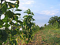 A view frae Çengeller veelage in Gölpazarı
 -

-
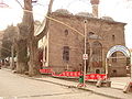 Çelebi Mehmet Mosque in Söğüt
 -
 The türbe o Dursun Fakih in Söğüt


References
- ↑ Turkish Statistical Institute, MS Excel document – Population of province/district centers and towns/villages and population growth rate by provinces
Freemit airtins
| Wikimedia Commons haes media relatit tae Bilecik Province. |
- (in Turkis) Bilecik govrenor's offeecial wabsteid
- (in Turkis) Bilecik municipality's official wabsteid
- (in Inglis) Bilecik wather forecast information
- (in Turkis) Yerel Yöneylem Kalkınma Derneği - Gölpazarı
- (in Turkis) Bayırköy's local wabsteid
- (in Turkis) Virtual platform o Bilecik
- (in Turkis) Virtual platform o Bilecik
| Urban destricts |  | |
|---|---|---|
| Rural destricts | ||
Regions | ||
| Aegean | ||
| Black Sea | ||
| Central Anatolie | ||
| Eastern Anatolie | ||
| Marmara | ||
| Mediterranean | ||
| Sootheastren Anatolie | ||
Coordinates: 40°06′24″N 30°07′33″E / 40.10667°N 30.12583°E