Samarkand
Appearance
Samarkand Uzbek: Samarqand, Самарқанд | |
|---|---|
| Coordinates: 39°42′N 66°59′E / 39.700°N 66.983°ECoordinates: 39°42′N 66°59′E / 39.700°N 66.983°E | |
| Country | |
| Province | Samarqand Province |
| Settled | 5t century BC |
| Govrenment | |
| • Teep | Ceety Admeenistration |
| • Hakim (Mayor) | Akbar Shukurov |
| Area | |
| • Total | 108 km2 (42 sq mi) |
| Elevation | 702 m (2,303 ft) |
| Population (2008) | |
| • Total | 436,300 |
| Time zone | UTC+5 ( ) |
| Website | http://samshahar.uz/ |
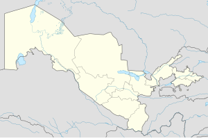
Samarkand (Uzbek: Samarqand; Tajik: Самарқанд; Persie: سمرقند; frae Sogdian: "Stane Fort" or "Rock Toun") is the seicont-lairgest ceety in Uzbekistan an the caipital o Samarqand Province. The ceety is maist notit for its central poseetion on the Silk Road atween Cheenae an the Wast, an for bein an Islamic centre for scholarly study. In the 14t century, it became the caipital o the empire o Timur (Tamerlane), an is the site o his mausoleum (the Gur-e Amir). The Bibi-Khanym Mosque remains ane o the ceety's maist notable laundmerks. The Registan wis the auncient centre o the ceety.
In 2001, UNESCO addit the ceety tae its Warld Heritage Leet as Samarkand – Crossroads o Culturs.
Sister ceeties
[eedit | eedit soorce] Nishapur, Iran
 Bukhara, Uzbekistan
 Balkh, Afghanistan
 Merv, Turkmenistan
 Cusco, Peru
 Lahore, Pakistan
 Lviv, Ukraine
 Kairouan, Tunisie
 Istanbul, Turkey
 İzmir, Turkey
 Khujand, Tajikistan
| Wikimedia Commons haes media relatit tae Samarkand. |


