Muş Province: Difference atween revisions
Appearance
Content deleted Content added
Created page with "{{Infobox Province TR |name=Muş |map=Mus in Turkey.svg |region = Eastren Anatolie |licence = 49 |total population = 406,886 |tpop_as_of = 2010 |area_code= 436 |area=8,196 |tu..." |
(Nae difference)
|
Reveision as o 22:07, 25 Januar 2012
Muş Province Muş ili | |
|---|---|
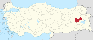
 Location of Muş Province in Turkey | |
| Kintra | Turkey |
| Region | Eastren Anatolie |
| Govrenment | |
| • Electoral destrict | Muş |
| Area | |
| • Tot | 8,196 km2 (3,164 sq mi) |
| Population (2010)[1] | |
| • Tot | 406,501 |
| • Density | 50/km2 (130/sq mi) |
| Area code(s) | 0436 |
| Vehicle registration | 49 |
Muş Province (Turkis: Muş ili) is a province in eastren Turkey. It is 8,196 km² in aurie, an haes a population o 406,886 (2010 est). The population wis 453,654 in 2000. The provincial caipital is the ceety o Muş (Armenie: Մուշ, Kurdish: Mûs). Anither toun in Muş province, Malazgirt (Manzikert), is famous for the Battle o Manzikert o 1071.
Destricts
Muş province is dividit intae 6 destricts (caipital destrict in bauld):
Historical steids

Amang the historical steids o the Mush province are twa o the holiest Armenie sites:
- the Saunt Karapet Monastery, which wis foondit in the 4t century bi Saunt Gregory the Illuminator an kept the relices o Saunt John the Baptist. It wis destroyed tae its foondations bi the Turkis airmy efter the Armenie Genocide.
- the Holy Apostles Monastery, a medieval monastery hoosin the relics o twa o the Apostles near the toun o Mush (an aw destroyed efter 1915)
Freemit airtins
- Govrenor's wab steid.
- Muş Weather Forecast Information
- Muş Wab Portal (Moush)
- Muş Fotoğrafları - Moush Photo Album
Notes
- ↑ Turkish Statistical Institute, MS Excel document – Population of province/district centers and towns/villages and population growth rate by provinces
Coordinates: 39°00′02″N 41°49′38″E / 39.00056°N 41.82722°E


