
Rio Grande da Serra
Rio Grande da Serra | |
|---|---|
 Banner  Coat airms | |
 Location o Rio Grande da Serra | |
| Coordinates: 23°44′38″S 46°23′52″W / 23.74389°S 46.39778°W | |
| Kintra | |
| Region | Sootheast |
| State | |
| Govrenment | |
| • Mayor | Adler Alfredo Jardim Teixeira (PSDB) |
| Area | |
| • Total | 36.7 km2 (14.2 sq mi) |
| Elevation | 780 m (2,560 ft) |
| Population | |
| • Total | 44,000 |
| • Density | 1198/km2 (3,100/sq mi) |
| Time zone | UTC-3 (UTC-3) |
| • Summer (DST) | UTC-2 (UTC-2) |
| HDI (2000) | 0.764 – medium |
| Website | Rio Grande da Serra |
Rio Grande da Serra is a municipality in the state o São Paulo in Brazil. It is locate aboot 49 kilometre (30 mi) bi road sootheast o the centre o the ceety o São Paulo, an is incorporatit intae the Microregion o São Paulo an the São Paulo Metropolitan Aurie. The population reportit bi the offeecial wabsteid o the Govrenment o Brazil is 44,000.
History
[eedit | eedit soorce]Early period
[eedit | eedit soorce]The earliest date recordit in the history o Rio Grande da Serra is 26 Mey 1560 whan laund wis allottit in Jeribatiba, the third veelage developit bi the Jesuits. Tae meet local needs, saut haed tae be brocht frae the port o São Vicente up tae the Alto da Serra heichlands via the veelage nou kent as Paranapiacaba. In 1640, the Marquês de Alegretti offeecially renamit Jeribatiba "Rio Grande". The mode o transport wis cuddies throu that period an Mogi das Cruzes, foondit in 1640, rapidly became the lairgest dounset. Salt wis transportit alang the sae-cried Caminho do Mar (sea road) tae Alto da Serra, locally kent as Zanzaláh an aw. Ane o the Jesuits wha dee'd on this route wis buriet wi a firthen cross whilk in 1611 wis convert intae a chapel, nou kent as the Capela de São Sebastião.[3][4]
Nineteent century
[eedit | eedit soorce]In 1840, General Antônio Manuel de Melo biggit a ranch on the road frae Mogi das Cruzes tae São Paulo. In 1855, a cholera epidemic caused devastation in the region.[3]
Till the nineteent century, the indwallers haed been engagit in pastoral activities. On 16 Februar 1867, the São Paulo Railwey reached Rio Grande, enablin coffee beans an timber tae be transportit tae São Paolo. As a result, the development o Rio Grande boomit, Housomeivver. it resultit in the influx o expatriates maistly frae Ingland wha establisht a new toun at Paranapiacaba an aw, a few mile awa.[4][5] The railwey encouragit the development o coal minin frae 1880 an bi 1895, that o manganese an graphite extraction an as well as mineral watter. Expatriates frae Italy, Germany an Swisserland came tae wirk at Rio Grande frae 1899 onwairds.[3]
Recent history
[eedit | eedit soorce]Work on the canalization o the Rio Grande river wis initiated in 1906. In 1918, graphite industry wis established. 1920 merked the the first telephone connection. In 1927, São Paolo municipality acquired Pedreira, a suburb of Rio Grande, bringin new factories wi opportunities for employment. In 1928, an electic pouer station wis biggit. Atween 1930 an 1954 mony sma scale industries, extensive housin facilities, mercatin centers an factories manufacturing aw kins o bien wis set up. Schools, sports centers, muisical events, carnivals an religious festivals emerged. Efter aw, thir developments the toun, Rio Grande da Serra, wis gien the status of municipality in 1964.[3][4] Population growthe in Rio Grande da Serra wis slaw til the mid-1970s, whan thare wis an influx of migrants, maistly miners whilk haes lestit til the day, tho the increase is nou faain.
Geography
[eedit | eedit soorce]

Rio Grande da Serra is ane o the 39 municipalities (Prefeituras) in the state of São Paulo unner the federal govrenment of Brazil.[6] The municipality is locatit approximately 49 kilometre (30 mi) bi road tae the southeast o the centre o the city of São Paulo accordin tae Google Maps, 55 kilometre (34 mi) accordin tae the municipal authorities.[1][7] Unner the Greater ABC region, its neighboring municipalities are Santo André, Ribeirão Pires an Suzano.[1] It covers an aurie of 36.7 square kilometre (14.2 sq mi). Wi the city of São Paulo an the municipalities of Diadema, Mauá, Ribeirão Pires, Santo André, São Bernardo do Campo an São Caetano do Sul, it forms pairt o the Microregion of São Paulo. The principal road is SP-122 (Rodovia Deputado Antônio Adib Chammas), which links tae Ribeirão Pires an Paranapiacaba. Paranapiacaba is a historical site approached bi road (15 minutes drive) frae Rio Grande da Serra, which haes train link wi Luz Station (Estaco da Luz) in São Paulo. The nearest internaitional airport is the Cumbica at Guarulhos which is quite far frae the city of São Paulo.[8]

The Rio Grande River Basin, wi its tributaries, form pairt o the municipality, wi the "Rio Grande arm" o the Billings Reservoir an Dam which is its maist significant geographical featur, covering a tot of 127 square kilometre (49 sq mi). It is named efter Asa White Kenney Billings, the United States hydroelectric engineer who wis instrumental in building it. The reservoir supplies aboot 1.8 million fowk, an an aa is uised for fishing an swimming. In addition tae Rio Grande da Serra an Sao Paulo, the Billings sub-basin includes Diadema, Ribeirao Pires, Santo Andre, an Sao Bernardo do Campo.[9] Besides the Rio Grande an Billings Reservoir an dam, the municipality haes a lot of streams an creeks, such as the streams of Figueira, Cloro, an Piolzinho.
Athin the city leemits, the wid auries an wetlands is statit tae be weel conserved, includin wild birds an ither ainimals. Its rainforests is an aa pertect unner suitable environmental laws an aw.[1]
Climate
[eedit | eedit soorce]The climate o the city, an athort the Metropolitan Region of São Paulo, is subtropical. Simmers is het an rainy, winters is mild, wi a constant haze atween Mey an October. The average annual temperature is aroond 18 °C, wi the cauldest month bein Julie (average 14 °C) an the hettest in Februar (average 22 °C). Annual rainfa is aroun 1,400 mm.
| Climate data for Rio Grande da Serra, Brazil (Average) | |||||||||||||
|---|---|---|---|---|---|---|---|---|---|---|---|---|---|
| Month | Jan | Feb | Mar | Apr | May | Jun | Jul | Aug | Sep | Oct | Nov | Dec | Year |
| Average heich °F (°C) | 81 (27) |
83 (28) |
81 (27) |
77 (25) |
74 (23) |
71 (22) |
71 (22) |
73 (23) |
73 (23) |
77 (25) |
78 (26) |
79 (26) |
83 (28) |
| Average law °F (°C) | 67 (19) |
67 (19) |
66 (19) |
63 (17) |
59 (15) |
56 (13) |
55 (13) |
56 (13) |
57 (14) |
60 (16) |
63 (17) |
65 (18) |
55 (13) |
| Average rainfaw inches (mm) | 9.5 (240) |
8.0 (200) |
5.6 (140) |
2.3 (58) |
1.7 (43) |
1.5 (38) |
1.1 (28) |
1.4 (36) |
2.3 (58) |
5.9 (150) |
4.8 (120) |
7.8 (200) |
51.9 (1,311) |
| Source: [10] | |||||||||||||
Demography
[eedit | eedit soorce]The population o the municipal toun is 44 000, which ower an aurie of 36.7 square kilometre (14.2 sq mi) gies a population density o 1,198 indwellers /sq km.[citation needit] Its Human Development growthe Index (HDI) is reportit tae be 0.764. The rate of Infant Mortality is 18.38 per thousan indwellers an life expectancy is 74 year. The urbanization rate is reportit tae be 10%.
Economy
[eedit | eedit soorce]The city's economy is dependent on eco-tourism, faimily fermin, intensive fermin, cooperatives an sma non-pollutin industries.[1] Fishin is practiced on the Billings Reservoir. Housomever, the issue o disposal o ceety waste watter an sewerage direct intae the reservoir frae the ceety is still an issue needin a solution.[11]
Economic activities in the form o sma scale craft industries in wid craft, dehydration o leafs, amang ithers, sculptures, fabric dolls, decorated boxes, ornaments, jewelry, pentins, artifacts frae recycled material hae providit job opportunities tae a nummer o artisans an aw.[12] The southeast on the road tae Paranapiacaba is a lairge industrial complex. A quarry commenced operations in 1927; the railwey communications enabled fast shipment of mined material.[12] In 1931, the ceety o São Paulo signed an agreement wi Licht & Pouer tae provide energy an stend the operation o the quarry. The quarry operations war terminated in the 1970s but the day it is ane o the mucklemaist quarries in Latin Americae at mair nor 640 metre (2,100 ft) lang an 70 metre (230 ft) heich an it is uised as a climmin venue.[12]
Notable landmarks
[eedit | eedit soorce]Capela de São Sebastião wis established in 1611. It is a white-washed structur in the colonial style. In 1906, a sculpture o Saint Sebastian wis addit tae the kirk.[12] The distinctive licht blue an white Our Lady of Grace Chapel (Igreja Nossa Senhora das Graças), accessed via a steep flicht o steps, wis established in 1949.[12] The kirk haes its feast day on 27t November. Estação Ferroviária, the railwey station wis inaugurated on 18 Februar 1867. Casa dos Castelucci an Casa família Rago is notable houses in the toun.[12]
Education
[eedit | eedit soorce]The toun is servit bi several schuils, includin:
- State School Prof. Francisco Lourenco de Melo - Vila Tsuzuki
- State School Luiz Edmundo de Nobrega Teixeira - Santa Tereza
- State School Prof. Sebastião Vayego de Carvalho - Vila Conde
- Escola Estadual Padre Giuseppe Pisoni - Vila Lopes
- State School Teacher Alziro Barbosa Nascimento - Vila St John
- Lucas Antonio State School - New Horizon
- State School Poet Cora Coralina - Americae Pairk
- Roberto Carlos Guariento State School - Vila Niwa
Gallery
[eedit | eedit soorce]-
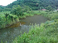 A naitural pond in Rio Grande da Serra
 -
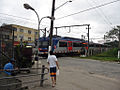 A train leavin the Rio Grande da Serra station


References
[eedit | eedit soorce]- ↑ Jump up to: a b c d e "Sobre o Município" (in Portuguese). Government of Rio Grande da Serra. Retrieved 26 Januar 2013.
- ↑ "Estimativas - Contagem da População 2007". IBGE. Retrieved 11 Julie 2008.
- ↑ Jump up to: a b c d "História" (in Portugese). Official web site of Government of Brazil. Archived frae the original on 13 Februar 2013. Retrieved 26 Januar 2013.CS1 maint: unrecognised leid (link)
- ↑ Jump up to: a b c "Rio Grande da Serra" (in Portuguese). Guiadedireitos.org. Archived frae the original on 4 Mairch 2016. Retrieved 26 Januar 2013.
- ↑ Regis St Louis; Gary Chandler (1 December 2010). Brazil. Lonely Planet. pp. 304–. ISBN 978-1-74179-163-1. Retrieved 3 Januar 2013.
- ↑ "004 Sao Paulo (Brazil)" (PDF). Metropolis organization. Archived frae the original (pdf) on 16 Mey 2012. Retrieved 26 Januar 2013.
- ↑ Google Maps – Rio Grande da Serra (Map). Cartografie bi Google, Inc. Google Inc. Retrieved 26 Januar 2013.
- ↑ Alex Robinson; Gardenia Robinson (17 Mey 2011). Brazil Handbook. Footprint Travel Guides. pp. 179–. ISBN 978-1-907263-26-2. Retrieved 3 Januar 2013.
- ↑ Bilibio, Carolina; Hensel, Oliver; Selbach, Jeferson Francisco (2012). Sustainable water management in the tropics and subtropics - and case studies in Brazil. 4. Jeferson Selbach. pp. 834–. ISBN 978-85-63337-23-8. Retrieved 26 Januar 2013.
- ↑ "Historic Average:Rio Grande da Serra, Brazil". Intellicast.com: The Authority in Expert Weather. Retrieved 26 Januar 2013.
- ↑ "Assessment of metals and trace elements in sediments from Rio Grande Reservoir, Brazil, by neutron activation analysis" (PDF). Springers. 21 Juin 2011. Archived frae the original (pdf) on 22 December 2015. Retrieved 26 Januar 2013.
- ↑ Jump up to: a b c d e f "Toursimo" (PDF) (in Portugese). Offeicial wabsteid o Govrenment o Brasil. Archived frae the original (pdf) on 26 Februar 2013. Retrieved 26 Januar 2013.CS1 maint: unrecognised leid (link)
Freemit airtins
[eedit | eedit soorce]| Wikimedia Commons haes media relatit tae Rio Grande da Serra. |
- Offeecial steid (in Portuguese)
Caipital: São Paulo | ||||
|  | |||
| ||||
| ||||
| ||||
| ||||
| ||||
| ||||
| ||||
| ||||
| ||||
| ||||
| ||||
| ||||
| ||||
| ||||