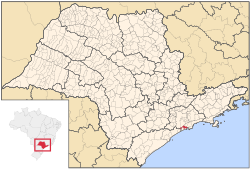
São Vicente, São Paulo
São Vicente | |
|---|---|
Ceety | |
| Município da Estância Balneária de São Vicente | |
| Eik-name(s): bolono | |
 Location o São Vicente | |
| Coordinates: 23°57′48″S 46°23′32″W / 23.96333°S 46.39222°W | |
| Kintra | |
| Region | Southeast |
| State | São Paulo |
| Govrenment | |
| • Mayor | Tércio Garcia |
| Area | |
| • Total | 148 km2 (57 sq mi) |
| Elevation | 6 m (20 ft) |
| Population (2007)[1] | |
| • Total | 323,599 |
| • Density | 2186.48/km2 (5,663.0/sq mi) |
| Time zone | UTC-3 (UTC-3) |
| • Summer (DST) | UTC-2 (UTC-2) |
| HDI (2000) | 0,798 – medium |
| Website | São Vicente City |
Coordinates: 23°57′48″S 46°23′32″W / 23.96333°S 46.39222°W
São Vicente is a coastal ceety o soothren São Paulo, Brazil. Its estimatit population in 2006 wis 329,370 inhabitants.
It was the first Portuguese permanent settlement in the Americas[2] an the first caipital o the Caiptaincy o São Vicente, nou the state o São Paulo. Established as a proper veelage in 1532 bi Martim Afonso de Sousa on wha wis then the Porto dos Escravos (port o the slaves), operatit bi three Portuguese colonists who trafficked on slaves captured bi alleed tribes, São Vicente is titled Cellula Mater (Mither Cell) o Brazil for being the first organizit toun in the kintra. The first Ceety Cooncil o aw the Americas wis democratically electit an established in São Vicente on 22 August 1532.
The day's ceety is positioned aff the island o São Vicente, being maistly a dormitory ceety for the portuary an commercial ceety o Santos, wi whom São Vicente share its island. São Vicente haes a sma fishin industry in its mainland aurie an aw.
A suspension brig linkin the island an the mainland wis first constructit in 1914. Neehbourheids include Humaitá, Parque das Bandeiras, Vila Ema an Quarentenário. São Vicente is linkit wi the Rodovia Manuel da Nóbrega.
It is the birthplace o soccer player Robinho.
Population history
[eedit | eedit soorce]| Year | Population | Density |
|---|---|---|
| 2003 | 314,312 | 2,123.73/km² |
| 2004 | 321,474 | 2,172.12/km² |
Internaitional relations
[eedit | eedit soorce]Twin touns — Sister ceeties
[eedit | eedit soorce]São Vicente is twinned wi:
References
[eedit | eedit soorce]Bibliography
[eedit | eedit soorce]- "Do Litoral ao Planalto". História do Brasil: Área Vicentina. Archived frae the original on 7 Juin 2007. Retrieved 7 Mairch 2012.
- Lawrence, Rachel (Januar 2010). Alyse Dar (ed.). Brazil (Seventh ed.). Apa Publications GmbH & Co. / Discovery Channel. pp. 183–204.
Notes
[eedit | eedit soorce]- ↑ "Estimativas - Contagem da População 2007". IBGE. Retrieved 11 Julie 2008.
- ↑ Rachel Lawrence: 2010, Page 183
- ↑ "Naha Sister Cities". Archived frae the original on 9 Mey 2007. Retrieved 7 Mairch 2012.
Freemit airtins
[eedit | eedit soorce]- (in Portuguese) São Vicente's offeecial hame page
- (in Portuguese) Portal Nosso São Paulo
- (in Portuguese) São Vicente São Paulo Brazil Archived 2018-12-22 at the Wayback Machine


