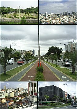
São Caetano do Sul
São Caetano do Sul | |
|---|---|
 Downtown São Caetano do Sul | |
 | |
| Coordinates: 23°42′00″S 46°33′00″W / 23.70000°S 46.55000°W | |
| Kintra | |
| Region | Southeast |
| State | |
| Govrenment | |
| • Mayor | José Auricchio Júnior (PTB) |
| Area | |
| • Total | 15.4 km2 (5.9 sq mi) |
| Elevation | 744 m (2,441 ft) |
| Population (2006) | |
| • Total | 133,241 |
| • Density | 8675/km2 (22,470/sq mi) |
| Time zone | UTC-3 (UTC-3) |
| • Summer (DST) | UTC-2 (UTC-2) |
| HDI (2000) | 0.921 – very high |
| Website | São Caetano do Sul São Caetano Guia |
São Caetano do Sul (or São Caetano) is a ceety in São Paulo state in Brazil, locatit in the Greater São Paulo Metropolitan Aurie. It is the ceety wi the heichest per caipita income in Brazil (US$ 16,500.00 in 2003) an it haes the heichest Human Development Index an aw (0.921 - atween Hong Kong an Germany).
Geografie
[eedit | eedit soorce]São Caetano do Sul is locatit on a plateau that is pairt o the Serra do Mar (Portuguese for "Sea Range"), pairt o the vast region kent as the Brazilian Heichlands, wi an average elevation o aroond 800 metres (2,625 ft) abuin sea level - tho at a distance o anerlie aboot 70 kilometer (43 mi) frae the Atlantic Ocean.
Climate
[eedit | eedit soorce]Accordin the Köppen climate classification São Caetano do Sul haes a humid subtropical climate.
The Best Staundart o Livin in Brazil
[eedit | eedit soorce]São Caetano do Sul boasts the heichest social indicators onywhaur in the kintra (even if uisin indexes sic as those that compute the HDI formula). Illiteracy rates are vera law an maist fowk enjoy a safe ceety wi well-maintained infrastructur. The anerlie shanty toun (favela) near São Caetano is a portion o the sootheastren corner o Heliopolis (São Paulo's lairgest slum) next tae the lairge Petrobras ile distribution an storage facility in nearbi Ipiranga. Sic border auries atween São Caetano an adjacent ceeties São Bernardo do Campo an Santo André are prone tae floodin which happens frequently especially in the mair impoverisht auries borderin the ceety o São Paulo, whaur the Meninos creek (a tributar o the hivily pollutit Tamanduateí river) is aften littered wi construction debris an garbage, exacerbatin the floodin effect in the rainy saison (Oct-Feb).
The ceety is servit bi a comprehensive netwirk o bus routes that connects São Caetano tae its neebourin touns an aw. Thare is ane commuter train line (operatit bi CPTM) that connects the ceety tae São Paulo an its neebours te the sooth an aw, Santo André an Mauá.
Demografics
[eedit | eedit soorce]Immigrants frae mony naitionalities hae settled in São Caetano but the maist significant groups are Italians, Spaniards, Portuguese, Germans an Japanese. In the 1950s, naitionals frae landwart Northeastren Brazil stairtit arrivin as the region experiencit a rapid industrialization boom.
Access tae domestic guids (% o population)
[eedit | eedit soorce]- Cellphones: 99.7%
- Telephone landlines: 99%
- Cars: 80.3%
- Personal Computers: 90.1%
- Colour TVs: 99.4%
- Freezers: 100%
Neebourheids
[eedit | eedit soorce]Santo André (East an Sooth), São Bernardo do Campo (Wast), São Paulo (North).
Heicher education
[eedit | eedit soorce]- Universidade Municipal de São Caetano do Sul, the Ceety Varsity o São Caetano do Sul
- Instituto Mauá de Tecnologia, Escola de Engenharia Mauá, São Caetano do Sul


