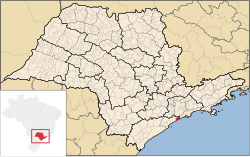
Mongaguá
Seaside Resort of Mongaguá | |
|---|---|
 | |
| Coordinates: 24°05′15.3″S 46°37′44″W / 24.087583°S 46.62889°WCoordinates: 24°05′15.3″S 46°37′44″W / 24.087583°S 46.62889°W | |
| Kintra | Brazil |
| State | São Paulo |
| Govrenment | |
| • Mayor | Artur Parada Prócida |
| Area | |
| • Total | 143.171 km2 (55.279 sq mi) |
| • Laund | 290.3 km2 (112.1 sq mi) |
| Elevation | 8 m (26 ft) |
| Population (2006) | |
| • Total | 46,977 |
| Time zone | UTC-2 (Brasília time) |
| Website | Mongagua.sp.gov.br |
Mongaguá is a municipality in the state o São Paulo in Brazil. The population in 2006 is 46,977, the population density is 328.11/km² an the aurie is 143 km². The name comes frae the Tupi leid.
The municipality's street plan is on a planned grid runnin frae SSE tae NNW an mony o the hooses are athin sicht o the Atlantic Ocean. The populatit aurie o Mongaguá is near the bottom o steep-slopin an densely forestit muntains. The BR-101 superheich-gate linkin Santos an the soothren pairt o the state runs throu Mongaguá. The freewey tae the ceety o São Paulo is easily accessible an aw. Hoosin developments near the beaches wur biggit in the 1970s an the 1990s. Prior tae the construction o the hoosin developments, the population wis mainly landwart. Hoosin development continues tae this day.
Thare are twa aboriginal veelages in Mongaguá: Itaóca an Aguapéu, located in the Atlantic Mata reserve. The aboriginal commonty o Aguapéu conceivit o the project Jaguatareí Nhemboé (Walkin an Learnin).
Population history[eedit | eedit soorce]
| Year | Population | Density |
|---|---|---|
| 2004 | 43,384 | 303.38/km² |
| 2006 | 46,977 | 328.11/km² |
Freemit airtins[eedit | eedit soorce]
- (in Portuguese) http://www.mongagua.sp.gov.br Archived 2021-02-13 at the Wayback Machine
- (in Portuguese) citybrazil.com.br Archived 2006-07-15 at the Wayback Machine
- (in Portuguese) Portal Nosso São Paulo[deid airtin]
| North: Praia Grande, São Paulo an São Vicente | ||
| Wast: Itanhaém | Mongaguá | East: Atlantic Ocean, São Vicente an Praia Grande |
| Sooth: Atlantic Ocean |


