Leicestershire
| Coonty | |
 Flag | |
| Motto: For'ard, For'ard | |
| Sovereign state | Unitit Kinrick |
|---|---|
| Constituent kintra | Ingland |
| Region | East Midlands |
| Ceremonial coonty | |
| Area | [convert: needs a number] |
| • Rankit | o 48 |
| • Rankit | o 48 |
| Density | [convert: needs a number] |
| Ethnicity | 85.0% White 11.9% S.Asian 1.2% Black British 1.5% Mixed Race |
| Time zone | Greenwich Mean Time (UTC) |
| • Simmer (DST) | Breetish Simmer Time (UTC+1) |
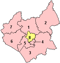
Leicestershire (![]() i/ˈlɛstəʃɪər/ or /ˈlɛstərʃər/; abbreviation Leics.) is a landlockit coonty in the Inglis Midlands. It takes its name frae the Ceety o Leicester, traditionally its admeenistrative centre, although the Ceety o Leicester unitary authority is the day admeenistered separately frae the rest o Leicestershire. The coonty borders Derbyshire tae the north-wast, Nottinghamshire tae the north, Rutland tae the east, Warwickshire tae the sooth-wast, Staffordshire tae the wast, Lincolnshire tae the north-east, an Northamptonshire tae the sooth-east. The border wi Warwickshire is Watling Street (the A5).
i/ˈlɛstəʃɪər/ or /ˈlɛstərʃər/; abbreviation Leics.) is a landlockit coonty in the Inglis Midlands. It takes its name frae the Ceety o Leicester, traditionally its admeenistrative centre, although the Ceety o Leicester unitary authority is the day admeenistered separately frae the rest o Leicestershire. The coonty borders Derbyshire tae the north-wast, Nottinghamshire tae the north, Rutland tae the east, Warwickshire tae the sooth-wast, Staffordshire tae the wast, Lincolnshire tae the north-east, an Northamptonshire tae the sooth-east. The border wi Warwickshire is Watling Street (the A5).

References[eedit | eedit soorce]
Freemit airtins[eedit | eedit soorce]
| Wikimedia Commons haes media relatit tae Leicestershire. |
