Calvados (depairtment)
Appearance
(Reguidit frae Calvados)
Calvados | |
|---|---|
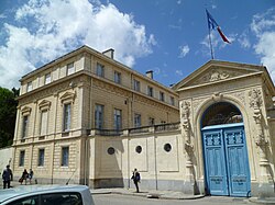
 Prefectur biggin o the Calvados depairtment, in Caen | |
 Location o Calvados in Fraunce | |
| Coordinates: 49°02′N 0°15′E / 49.033°N 0.250°ECoordinates: 49°02′N 0°15′E / 49.033°N 0.250°E | |
| Kintra | Fraunce |
| Region | Normandy |
| Prefectur | Caen |
| Subprefecturs | Bayeux Lisieux Vire |
| Govrenment | |
| • Preses o the General Cooncil | Anne d'Ornano (Miscellaneous Right-wing) |
| Area | |
| • Total | 5548 km2 (2,142 sq mi) |
| Population (2011) | |
| • Total | 685 262 |
| • Rank | 34t |
| Time zone | UTC+1 (CET) |
| • Summer (DST) | UTC+2 (CEST) |
| Depairtment nummer | 14 |
| Arrondissements | 4 |
| Cantons | 25 |
| Communes | 705 |
| ^1 French Land Register data, which exclude estuaries, an lochs, ponds, an glaciers lairger nor 1 km2 | |
Calvados (French pronunciation: [kal.va.dos]; Inglis /ˈkælvədoʊs/) is a depairtment in the Lawer Normandy region in northwastren Fraunce.[1]
References
[eedit | eedit soorce]- ↑
 Chisholm, Hugh, ed. (1911). . Encyclopædia Britannica (11th ed.). Cambridge University Press. Cite has empty unkent parameters:
 |HIDE_PARAMETER15=,|HIDE_PARAMETER13=,|HIDE_PARAMETER14c=,|HIDE_PARAMETER14=,|HIDE_PARAMETER9=,|HIDE_PARAMETER3=,|HIDE_PARAMETER1=,|HIDE_PARAMETER4=,|HIDE_PARAMETER2=,|HIDE_PARAMETER8=,|HIDE_PARAMETER20=,|HIDE_PARAMETER5=,|HIDE_PARAMETER7=,|HIDE_PARAMETER10=,|separator=,|HIDE_PARAMETER14b=,|HIDE_PARAMETER6=,|HIDE_PARAMETER11=, and|HIDE_PARAMETER12=(help)


