Seine-Maritime
Appearance
Seine-Maritime | |
|---|---|
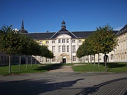
 Prefectur biggin o the Seine-Maritime depairtment, in Rouen | |
 Location o Seine-Maritime in Fraunce | |
| Coordinates: 49°40′N 0°50′E / 49.667°N 0.833°E | |
| Country | France |
| Region | Normandy |
| Prefecture | Rouen |
| Subprefectures | Dieppe Le Havre |
| Govrenment | |
| • President of the General Council | Didier Marie |
| Area | |
| • Total | 6278 km2 (2,424 sq mi) |
| Population (2006) | |
| • Total | 1,243,834 |
| • Rank | 13th |
| • Density | 200/km2 (510/sq mi) |
| Time zone | UTC+1 (CET) |
| • Summer (DST) | UTC+2 (CEST) |
| Department number | 76 |
| Arrondissements | 3 |
| Cantons | 69 |
| Communes | 745 |
| ^1 French Land Register data, which exclude estuaries, and lakes, ponds, and glaciers larger than 1 km2 | |
Seine-Maritime (French pronunciation: [sɛn.ma.ʁi.tim]) is a French depairtment in the Normandy region o northren Fraunce. It is situatit on the northren coast o Fraunce, at the mooth o the Seine, an includes the ceeties o Rouen an Le Havre. Till 1955 it wis namit Seine-Inférieure.
See an aw
[eedit | eedit soorce]- Cantons o the Seine-Maritime depairtment
- Communes o the Seine-Maritime depairtment
- Arrondissements o the Seine-Maritime depairtment
Sources an further readin
[eedit | eedit soorce]Freemit airtins
[eedit | eedit soorce]- (in French) General Cooncil wabsteid Archived 2007-10-26 at the Wayback Machine
- (in French) Communes 76
- (in French) Prefectur wabsteid

