Cher (depairtment)
Appearance
Cher | |
|---|---|
 Prefectur biggin o the Cher depairtment, in Bourges | |
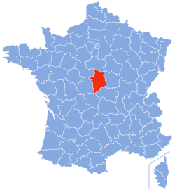
 Location o Cher in Fraunce | |
| Coordinates: 47°0′N 2°35′E / 47.000°N 2.583°ECoordinates: 47°0′N 2°35′E / 47.000°N 2.583°E | |
| Kintra | Fraunce |
| Region | Centre-Val de Loire |
| Prefectur | Bourges |
| Subprefecturs | Saint-Amand-Montrond Vierzon |
| Govrenment | |
| • Preses o the General Cooncil | Alain Rafesthain (PS) |
| Area | |
| • Total | 7235 km2 (2,793 sq mi) |
| Population (2008) | |
| • Total | 313,251 |
| • Rank | 70t |
| • Density | 43/km2 (110/sq mi) |
| Time zone | UTC+1 (CET) |
| • Summer (DST) | UTC+2 (CEST) |
| Depairtment nummer | 18 |
| Arrondissements | 3 |
| Cantons | 19 |
| Communes | 290 |
| ^1 French Land Register data, which exclude estuaries, an lochs, ponds, an glaciers lairger nor 1 km2 | |
Cher (French pronunciation: [ʃɛʁ]; Berrichon: Char) is a depairtment in the Centre-Val de Loire region o Fraunce.

