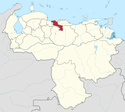
Aragua
{{{official_name}}} Estado Aragua | |
|---|---|
| Motto(s): Venezuela's Hearth | |
 Location athin Venezuela | |
| Kintra | Venezuela |
| Created | 1899 |
| Caipital | Maracay |
| Govrenment | |
| • Govrenor | Rafael Isea (2008–2012) |
| Area | |
| • Total | 7014 km2 (2,708 sq mi) |
| Area rank | 20t |
| 0.76% of Venezuela | |
| Population (2008 est.[1]) | |
| • Total | 1,689,056 |
| • Rank | 6t |
| 6.28% o Venezuela | |
| Time zone | UTC-04:00 |
| ISO 3166 code | VE-D |
| Emblematic tree | Samán (Pithecellobium saman) |
| Website | www |
Aragua State (Spaingie: Estado Aragua, IPA: [esˈtaðo aˈɾaɣwa]) ane o the 23 States o Venezuela. It is locatit in the north-central region o Venezuela. It haes plains an jungles an Caribbean beaches. The maist popular are Cata an Choroni. It haes Venezuela's first naitional pairk which is cried Henri Pittier.
The caipital is Maracay, ither important ceeties include Turmero an El Limón.
The name Aragua is said tae derive frae a Cumanagota wird for a teep o palm, roystonea oleracea.
History
[eedit | eedit soorce]Aragua wis pairt o the Venezuela Province till 1848, when the Province wis split intae three pairts, ane being Aragua Province. The Province became a state in 1864. Some mergers an demergers wi ither states follaeed, till Aragua became a autonomous state again in 1901. Its caipital till 1917 wis La Victoria (steid o the Venezuelan War o unthirldom's Battle o La Victoria), when the caipital wis muivit tae Maracay.[2]
Geografie
[eedit | eedit soorce]Aragua borders the Caribbean Sea tae the north, wi its coastline backit bi the fast-risin central Cordillera muntain range. Codazzi Peak reaches ower 2400 m abuin sea level. Hintle o the rest o the state is made up o fertile valleys uised for intensive agricultur, apairt frae in the extreme sooth whaur the flats o the central Llanos region begin. On the wastren border is Loch Valencia.
The main rivers in the state are the Aragua, the Guárico, the El Limón, the Tuy, the Pao an the Turmero. They flow intae the Caribbean Sea, Loch Valencia, or feed the vast Orinoco River netwirk. The Camatagua reservoir is ane o the main reservoirs supplyin Caracas.
Municipalities an municipal seats
[eedit | eedit soorce]Aragua comprises aichteen municipalities (municipios):[3]
- Bolívar (San Mateo)
- Camatagua (Camatagua)
- Francisco Linares Alcántara (Santa Rita)
- Girardot (Maracay)
- José Angel Lamas (Santa Cruz)
- José Félix Ribas (La Victoria)
- José Rafael Revenga (El Consejo)
- Libertador (Palo Negro)
- Mario Briceño Iragorry (El Limón)
- Ocumare de la Costa de Oro (Ocumare de la Costa)
- San Casimiro (San Casimiro)
- San Sebastián (San Sebastián)
- Santiago Mariño (Turmero)
- Santos Michelena (Las Tejerías)
- Sucre (Cagua)
- Tovar (Colonia Tovar)
- Urdaneta (Barbacoas)
- Zamora (Villa de Cura)
References
[eedit | eedit soorce]- ↑ (in Spaingie) INE, Situacion Fisica, accessed 23 June 2012
- ↑ (in Spaingie) INE, Historia Archived 2013-04-21 at Archive.today
- ↑ (in Spaingie) INE, Division Politico Territorial[deid airtin], accessed 23 June 2012
See an aw
[eedit | eedit soorce]
Freemit airtins
[eedit | eedit soorce]| Wikimedia Commons haes media relatit tae Aragua. |
- Ciudad Maracay. Information aboot Maracay an Aragua State Archived 2008-04-10 at the Wayback Machine
- (in Spaingie) INE, Population statistics for Aragua Archived 2013-10-02 at the Wayback Machine


