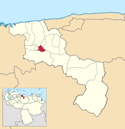
Sucre, Aragua
Sucre Municipality Municipio Sucre | |
|---|---|
 Location in Aragua | |
| Coordinates: 10°11′N 67°27′W / 10.183°N 67.450°WCoordinates: 10°11′N 67°27′W / 10.183°N 67.450°W | |
| Kintra | |
| State | Aragua |
| Municipal seat | Cagua |
| Govrenment | |
| • Mayor | Eusebio Agüero (PSUV) |
| Area | |
| • Total | 62.5 km2 (24.1 sq mi) |
| Population (2007) | |
| • Total | 120,302 |
| • Density | 1,900/km2 (5,000/sq mi) |
| Time zone | UTC−04:00 (VET) |
| Aurie code(s) | 0244 |
| Website | Offeecial wabsteid |
Sucre is ane o the 18 municipalities (municipios) that maks up the Venezuelan state o Aragua an, accordin tae a 2007 population estimate bi the Naitional Institute o Statistics o Venezuela, the municipality haes a population o 120,302.[1] The toun o Cagua is the shire toun o the Sucre Municipality.[2] The municipality is ane o several in Venezuela named "Sucre Municipality" in honour o Venezuelan unthirldom hero Antonio José de Sucre.
History
[eedit | eedit soorce]The toun o Cagua wis first established as Cagua la Vieja in 1620 an wis oreeginally made up o Spaniards. The oreegin o the name Cagua, comes frae the native wird Cahiua, which means snail. Cagua wis rebuilt in its current location in 1622 unner the new name o Nuestra Señora del Rosario de Cagua, which wis later chyngit tae San Jose de Cagua durin the 18t century. The ceety is nou kent as juist Cagua.
Cagua is a smaw ceety wi several squares an haes a tropical climate. It's ane o the maist important ceeties o Aragua acause o its proximity tae Maracay, the state caipital an Caracas. Cagua haes been, for a lang time, a important industrial zone.
One of its most important places are Casa Guipuzcoana and the Mountain "El Empalado", where original natives were burned alive by Spanish colonizers; this mountain is rich in marble and typical plants such as Araguaney, Samán, Bucare, and Apamate.
Steids o interest
[eedit | eedit soorce]- Sucre square
- Casa Guipuzcoana
- Marble Mines
- Empalado Muntain
- Auld Mill
- Saunt Joseph Kirk
- Taiguaiguay Loch
Demographics
[eedit | eedit soorce]The Sucre Municipality, accordin tae a 2007 population estimate bi the Naitional Institute o Statistics o Venezuela, haes a population o 120,302 (up frae 109,723 in 2000). This amoonts tae 7.2% o the state's population.[3] The municipality's population density is 1,582.92 inhabitants per square kilometre (4,099.7/sq mi).[4]
Govrenment
[eedit | eedit soorce]The mayor o the Sucre Municipality is Eusebio de la Cruz Agüero, electit on 8 Dizember 2013 wi 51,66% o the vote.[5] He replacit Luis Zambrano shortly efter the elections. The municipality is dividit intae twa pairishes; Capital Sucre an Bella Vista.[2]
References
[eedit | eedit soorce]- ↑ http://www.ine.gob.ve/sintesisestadistica/estados/aragua/cuadros/Poblacion6.xls[deid airtin]
- ↑ a b http://www.ine.gob.ve/secciones/division/Aragua.zip[deid airtin]
- ↑ http://www.ine.gob.ve/sintesisestadistica/estados/aragua/cuadros/Poblacion5.xls[deid airtin]
- ↑ http://www.ine.gob.ve/sintesisestadistica/estados/aragua/cuadros/Poblacion4.xls[deid airtin]
- ↑ http://www.cne.gob.ve/resultado_municipal_2013/r/1/reg_040600.html
Freemit airtins
[eedit | eedit soorce]- sucre-aragua.gob.ve Archived 2005-12-03 at the Wayback Machine (in Spaingie)


