Uşak Province: Difference atween revisions
Appearance
Content deleted Content added
Created page with "{{Infobox Province TR |name = Uşak |map = Usak in Turkey.svg |region = Aegean |licence = 64 |total population = 338,019 |tpop_as_of = 2010 |area_code= 276 |area= 5,341 |websi..." Tag: links from new uiser |
(Nae difference)
|
Reveision as o 17:07, 8 Februar 2012
Uşak Province Uşak ili | |
|---|---|
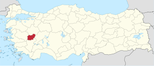
 Location of Uşak Province in Turkey | |
| Kintra | Turkey |
| Region | Aegean |
| Govrenment | |
| • Electoral destrict | Uşak |
| Area | |
| • Tot | 5,341 km2 (2,062 sq mi) |
| Population (2010)[1] | |
| • Tot | 358,736 |
| • Density | 67/km2 (170/sq mi) |
| Area code(s) | 0276 |
| Vehicle registration | 64 |
| Website | http://www.usak.gov.tr/ |
Uşak (Turkis: Uşak ili) is a province in wastren Turkey. Its adjacent provinces are Manisa to the west, Denizli to the south, Afyon to the east, and Kütahya to the north. The provincial capital is Uşak, and its traffic code is 64. The province covers an area of 5,341 km² and has a population of 335,860 (2009 est). The population was 322,313 in 2000.(338,019 as of 2010)
Districts
Uşak province is divided into 6 districts (capital district in bold):
Gallery
-
1898-built Dülgeroğlu Hoose in Uşak
-
Clandıras brig near Karahallı
References
- ↑ Turkish Statistical Institute, MS Excel document – Population of province/district centers and towns/villages and population growth rate by provinces
Freemit airtins
| Wikimedia Commons haes media relatit tae Uşak Province. |
- (in Turkis) Uşak govrenor's offeecial wabsteid
- (in Turkis) Uşak municipality's offeecial wabsteid
Coordinates: 38°31′26″N 29°20′31″E / 38.52389°N 29.34194°E


