Qarshi
Qarshi Қарши | |
|---|---|
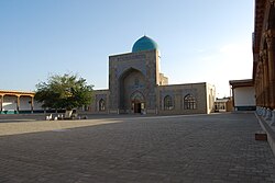
 Kok-Gumbaz mosque in Qarshi | |
| Coordinates: 38°52′N 65°48′E / 38.867°N 65.800°E | |
| Kintra | |
| Province | Qashqadaryo Province |
| Population (1999) | |
| • Total | 197,600 |
Qarshi (Uzbek: Qarshi / Қарши; Persie: نخشب; Mongolie: Харш; Roushie: Карши) is a ceety in soothren Uzbekistan. It is the caipital o Qashqadaryo Province an haes a population o 197,600 (1999 census estimate). It is aboot 520 km sooth-soothwast o Tashkent, an aboot 335 km north o Uzbekistan's mairch wi Afghanistan. It is locatit at latitude 38° 51' 48N; langitude 65° 47' 52E at an altitude o 374 meters. The ceety is important in naitural gas production, but Qarshi is an aa famous for its production o weaved flat cairpets.
History
[eedit | eedit soorce]Oreeginally the Sogdian ceety o Nakhshab, an the Islamic Persian ceety o Nasaf, Qarshi wis the seicont ceety o the Emirate o Bukhara. It is in the centre o a fertile oasis that produces wheat, cotton, an silk an wis a stap on the 11 day caravan route atween Balkh an Bukhara. The Chagatai Mongol khans Kebek an Qazan biggit pailaces here on the site o Genghis Khan's simmer pastur[1]. In 1364, Timur an aa biggit a fortifee'd pailace wi moats in wha is nou the soothren pairt o the ceety. The modren name "Qarshi" means fort.
Wi the decline o Shahrisabz in the 18t century, Qarshi grew in importance, an wis the seat o the Croun Prince tae the Emirate o Bukhara. The ceety haed a dooble set o waws, 10 caravanserais an 4 madrassahs durin this time. Bi 1868, the Roushies haed annexed the Zarafshan Valley, an in 1873, the treaty turnin Bukhara intae a Roushie pertectorate wis signed in Qarshi, muckle tae the dismay o the Emir's son, Abdul Malik, who teuk tae the hills in rebellion.
In the early 1970s, the first section o a major irrigation project wis completit tae divert watter frae the Amu Darya River in Turkmenistan eastward intae Uzbekistan in order tae irrigate the land surroondin Qarshi. Amaist aw o thir irrigatit lands aroond Qarshi are plantit wi cotton.
Points o interest
[eedit | eedit soorce]- Khoja Adbul Aziz Madrassah - lairgest in toun, nou hoosin the Regional Museum
- Rabiya Madrassah - a late 19t century female madrassah
- Kok Gumbaz Mosque - pairt o a 16t century complex o biggins
- Warld War II Memorial - Aiblins ane o the ex-Soviet Union's maist monumental monuments
Coordinates: 38°52′N 65°48′E / 38.867°N 65.800°E
Notes
[eedit | eedit soorce]- ↑ Grousset, pp. 341-2 states that baith khans uised Qarshi as a caipital
References
[eedit | eedit soorce]- Grousset, René. The Empire of the Steppes: A History of Central Asia. Trans. Naomi Walford. New Jersey: Rutgers, 1970. ISBN 0813513049
| Wikimedia Commons haes media relatit tae Qarshi. |

