Vaupés
Appearance
Depairtment o Vaupés Departamento del Vaupés | |
|---|---|
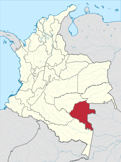
 Vaupés shown in red | |
| Coordinates: 1°12′N 70°10′W / 1.200°N 70.167°W | |
| Kintra | |
| Region | Amazonía Region |
| Established | 4 Julie 1991 |
| Caipital | Mitú |
| Govrenment | |
| • Govrenor | José Leónidas Soto (2008-) |
| Area | |
| • Total | 54135 km2 (20,902 sq mi) |
| Area rank | 7 |
| Population (2005)[1] | |
| • Total | 27,124 |
| • Rank | 33 |
| • Density | 0.50/km2 (1.3/sq mi) |
| Time zone | UTC-05 |
| ISO 3166 code | CO-VAU |
| Municipalities | 6 |
| Website | www.vaupes.gov.co |
Vaupés is a department o Colombie in the jungle covered Amazonas Region. It is locatit in the sootheast pairt o the kintra, borderin Brazil tae the east, the depairtment o Amazonas tae the sooth, Caquetá an Guaviare, an Guainía tae the north coverin a total aurie o 54,135 km². Its caipital is the toun o Mitú.
Admeenistrative diveesions
[eedit | eedit soorce]Acause o its sma population an vast extension o land, Vaupés anerlie haes 3 municipalities. Ither sections o the depairtment wur classifeed as an especial type o corregimiento, which haes certain hybrid functions frae a municipality an corregimiento.


