Sucre, Colombie
Depairtment o Sucre Departamento de Sucre | |
|---|---|
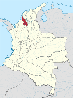
 Sucre shown in red | |
| Coordinates: 9°18′N 75°24′W / 9.300°N 75.400°W | |
| Kintra | |
| Region | Caribbean Region |
| Established | 18 August 1966 |
| Caipital | Sincelejo |
| Lairgest ceety | Sincelejo |
| Govrenment | |
| • Govrenor | Jorge Carlos Barraza Farak (Partido Social de Unidad Nacional) |
| Area | |
| • Total | 10670 km2 (4,120 sq mi) |
| Area rank | 27 |
| Population (2005)[1] | |
| • Total | 772,010 |
| • Rank | 20 |
| • Density | 72/km2 (190/sq mi) |
| Time zone | UTC-05 |
| ISO 3166 code | CO-SUC |
| Municipalities | 26 |
| Website | www.gobersucre.gov.co |
Sucre is a depairtment in the Caribbean Natural Region o Colombie. The depairtment ranks 27t bi aurie, 10,670 km2 (4,120 sq mi) an it haes a population o 772,010, rankin 20t o aw the 32 depairtments o Colombie. Sucre is bordered bi the Caribbean on the northwast; bi Bolívar on the east an bi Córdoba on the wast.
Sucre wis namit in honor o the unthirldom hero Antonio José de Sucre who wis quotit bi the foonders o this depairtment in reference tae Simón Bolívar's daith as saying "They hae killed ma hert", spression said while cruisin the territory o the present day Sucre Depairtment.
As o 2009, the Sucre Depairtment haes an estimatit population o 802,733, o which 234,886 are in the depairtment caipital Sincelejo, accordin tae the DANE projections.
References
[eedit | eedit soorce]Freemit airtins
[eedit | eedit soorce]- (in Spaingie) Govrenment o Sucre offeecial wabsteid Archived 2007-09-29 at the Wayback Machine
| Wikimedia Commons haes media relatit tae Sucre (departamento). |


