Poltava Oblast
Poltava Oblast Полтавська область Poltavs’ka oblast’ | |
|---|---|
| Eik-name(s): [Полтавщина (Poltavshchyna)] error: {{lang}}: text has italic markup (help) | |
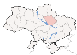
 Location o Poltava Oblast (red) athin Ukraine (blue) | |
| Kintra | |
| Admin. centre | Poltava |
| Govrenment | |
| • Governor | Valeriy Holovko (Batkivshchyna) |
| • Oblast cooncil | ? seats |
| • Chairperson | Petro Vorona (UDAR) |
| Area | |
| • Total | 28748 km2 (11,100 sq mi) |
| Area rank | Ranked 6t |
| Population (2006) | |
| • Total | 1,544,085 |
| • Rank | Ranked 12t |
| • Density | 54/km2 (140/sq mi) |
| Time zone | UTC+2 (EET) |
| • Summer (DST) | UTC+3 (EEST) |
| Postal code | |
| Aurie code | +380-53 |
| ISO 3166 code | UA-53 |
| Raions | 4 |
| Ceeties (tot) | 15 |
| Touns | 21 |
| Veelages | 1831 |
| FIPS 10-4 | UP18 |
| Website | www.obladmin.poltava.ua |
Poltava Oblast (Ukrainian: Полтавська область, translit. Poltavs’ka oblast’; an aw referred tae as Poltavshchyna – Ukrainian: Полтавщина) is an oblast (province) o central Ukraine. The admeenistrative centre o the oblast is the ceety o Poltava.
Ither important ceeties athin the oblast include: Horishni Plavni, Kremenchuk, Lubny an Myrhorod.
Geography
[eedit | eedit soorce]Poltava Oblast is situatit in the central pairt o Ukraine. It haes an aurie o 28,800 km². The oblast’ borders upon Chernihiv, Sumy, Kharkiv, Dnipropetrovs’k, Kirovohrad, Cherkasy an Kiev regions.
Points o interest
[eedit | eedit soorce]The follaein historic-cultural steids wur nominatit for the Seiven Wanders o Ukraine.
- Gogol preserve-museum
- Kotliarevsky villa
- Mykolaivska Kirk
- Polatava ethnical museum
- Cross-Erectin monastery
Demographics
[eedit | eedit soorce]At 2005-05-01, its population wis 1,584,446, an population density wis 59 fowk per 1 km².
Economy
[eedit | eedit soorce]Industry
[eedit | eedit soorce]The oblast’ is a centre o Ukraine's ile an natural gas industry, wi mony wells an pipelines situatit here. Thare is a major ile refinery plant in the ceety o Kremenchuk. Important iron ore processin facilities an aw present. In general thare are 374 lairge industrial organisation an 618 sma industrial organisations.
Agricultur
[eedit | eedit soorce]In 1999 the gross grain yield wis aboot 1452,9 thoosan tons, succar beets – 1002,900 tons, sunflouer seeds – 166,200 tons, potatoes – 279,900 tons. The oblast an aw producit 120,500 tons o meat, 645,900 tons o milk an 423,200,00 eggs. At the beginnin o 1999 thare wur 1,311 registered ferms in the region.
Admeenistrative diveesions
[eedit | eedit soorce]The oblast is dividit intae 25 destricts, 15 ceeties includin 5 settlements o ceety estate, 21 urban veelages, an 1862 veelages.
The follaein data incorporates the nummer o each type o admeenistrative diveesions o the Poltava Oblast’:
- Admeenistrative centre – 1 (Poltava)
- Raions — 25;
- Ceety raions — 5;
- Settlements — 1526, includin:
- Veelages — 1,831;
- Ceeties/Touns — 35, includin:
- Urban-type settlement — 21;
- Ceeties — 15, includin:
- Ceeties o oblast' subordinance — 7;
- Ceeties o raion subordinance — 8;
- Settlement cooncils — 384.
The local admeenistration o the oblast' is controlled bi the Poltava Oblast Rada. The govrenor o the oblast’ is the Poltava Oblast’ Rada speaker, appointit bi the Preses o Ukraine.
Nomenclatur
[eedit | eedit soorce]Maist o Ukraine's oblasts are namit efter thair caipital ceeties, offeecially referred tae as "oblast centres" (Ukrainian: обласний центр, translit. oblasnyi tsentr). The name o each oblast is a relative adjective, formit bi addin a feminine suffix tae the name o respective centre ceety: Poltava is the centre o the Poltavs’ka oblast’ (Poltava Oblast). Maist oblasts are an aw whiles referred tae in a feminine noun form, follaein the convention o traditional regional place names, endin wi the suffix "-shchyna", as is the case wi the Poltava Oblast, Poltavshchyna.
References
[eedit | eedit soorce]External links
[eedit | eedit soorce]- State Administration of Poltava Region Archived 2012-05-10 at the Wayback Machine – offeecial site (in Ukrainian)
- Information Card of the Region – offeecial site o the Cabinet o Ministers o Ukraine


