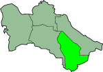
Mary Province

Mary Province (Turkmen: Mary welaýaty, Мары велаяты) is ane o the welayatlar (provinces) o Turkmenistan. It is in the sooth-east o the kintra, borderin Afghanistan. Its caipital is the ceety o Mary. Its aurie is 87,150 km2 (33,650 sq mi) an population 1,480,400 (2005 est.).[1] The average population density is aboot 15 persons per square kilometer, but it reaches 150-200 per square kilometer in the maist developed oases.
In 2000, Mary Province accoontit for 23% o Turkmenistan's population, 19% o the tot nummer o employed, 26% o agricultural production (bi value), an 21% o the kintra's tot industrial production.[2] The region's industries include natural gas extraction (the Iolotan gas field), electric pouer generation, textiles, carpet weavin, chemical an fuid industry. In 2001 it accoontit for 74% o Turkmenistan's electricity generation 26% o natural gas extraction.[3] Accordin tae ither soorces, Mary Province accoonts for 81% o fertilizer production, 40% o textiles, 81% o laither, an 23% o fuitwear. Mary agriculture produces 31% o Turkmenistan's cotton fibres an 32% o its vegetable oil.
Agriculture in Mary Province is irrigatit bi the Karakum Canal, which runs east tae wast throu the centre o the province, an bi the Murghab River, which runs sooth tae north, enterin the province frae Afghanistan. While the northren portion o the province is athin the Central Asian soothren desert ecoregion, the soothren portion o the province is characterized bi a savanna o pistachio an desertsedges, clessifee'd as the Badkhiz-Karabil semi-desert bi the Warld Wildlife Fund [4][5]>[the cited link daes nae lead tae this information: need a direct link]
Auncient Merv, designatit a UNESCO Warld Heritage Site, is the main archeological attraction o Mary Province. This is ane o the best preserved oasis ceeties on the auncient silk route.[6]
The caipital o Mary Province is the ceety o Mary, locatit at the intersection o Murghab River wi the Karakum Canal. Ither ceeties are Baýramaly (Roushie: Байрам-Али), Ýolöten (Iolotan, Roushie: Иолотань), an Serhetabat (Roushie: Серхетабад, umwhile Turkmen: Guşgy, Roushie: Кушка) on the border wi Afghanistan.
Districts
[eedit | eedit soorce]Mary Province is dividit intae 12 destricts (etraplar; singular etrap) an ane ceety (il)[7][8]. Name changes syne 1995 are shawn in parentheses:
- Baýramaly Ceety
- Altyn Sahra District (formed in Aprile 2008)[9][10]
- Baýramaly District
- Ýolöten District
- Garagum District
- Mary District
- Murgap District
- Oguzhan District (umwhile Howuzhan Destrict)
- Sakarçäge District
- Serhetabat District (umwhile Guşgy Destrict)
- Tagtabazar District
- Türkmengala District
- Wekilbazar District
References
[eedit | eedit soorce]- ↑ Statistical Yearbook of Turkmenistan 2000-2004, National Institute of State Statistics and Information of Turkmenistan, Ashgabat, 2005.
- ↑ Social-economic situation of Turkmenistan in 2000, National Institute of State Statistics and Information of Turkmenistan, Ashgabat, 2001, pp. 137-138 (in Roushie).
- ↑ Social-economic situation of Turkmenistan in 2001, National Institute of State Statistics and Information of Turkmenistan, Ashgabat, 2002, pp. 107-109 (in Roushie).
- ↑ http://www.nationalgeographic.com/wildworld/profiles/terrestrial_pa.html
- ↑ http://www.worldwildlife.org/wildfinder/searchByPlace.cfm?ecoregion=PA1306
- ↑ Bonneville, Patrick and Hemono, Philippe. 2006. The World Heritage. Bonneville Connection, Quebec
- ↑ "Марыйский Велаят". Archived frae the original on 28 Julie 2009. Retrieved 30 November 2010.
- ↑ Turkmenistan Districts
- ↑ Halk Maslahaty resolution on the creation of Altyn Sahra district Archived 2009-01-08 at the Wayback Machine, 18 April 2008 (in Roushie). Retrieved on 24 January 2009.
- ↑ Press announcement on the creation of Altyn Sahra district, 19 April 2008 (in Roushie). Retrieved on 24 January 2009.
