Aiberdeenshire
Aiberdeenshire Aberdeenshire Siorrachd Obar Dheathain | |
|---|---|
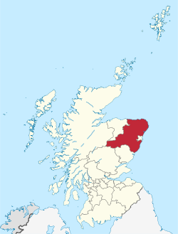
 Aiberdeenshire within Scotland | |
| Coordinates: 57°9′3.6″N 2°7′22.8″W / 57.151000°N 2.123000°WCoordinates: 57°9′3.6″N 2°7′22.8″W / 57.151000°N 2.123000°W | |
| Admin HQ | Aberdeen |
| Govrenment | |
| • Bodi | Aberdeenshire Cooncil |
| • Control | Con + LD + Ind (cooncil NOC) |
| • MPs |
|
| • MSPs |
|
| Area | |
| • Total | 6313 km2 (2,437 sq mi) |
| Area rank | Ranked 4t |
| Population (mid-2016 est.) | |
| • Total | 262,200 |
| • Rank | Rankit 6th |
| • Density | 41/km2 (110/sq mi) |
| ONS code | S12000034 |
| ISO 3166 code | GB-ABD |
| Website | www |
Aiberdeenshire (Scots Gaelic: Siorrachd Obar Dheathain, Inglis: Aberdeenshire) is ane o the 32 cooncil areas o Scotland an a lieutenancie area anaw.
Aiberdeenshire cooncil area disna kiver the Ceitie o Aiberdeen. Hit is nou a sindert cooncil area. Thegither, the modren cooncil area an the ceitie mad up historic Aiberdeenshire - ane o the coonties o Scotland umwhyl bruikit for local govrenment. Athin thir borders, the Coontie o Aiberdeen byds as a registration coontie.
Aiberdeenshire Cooncil haes its heidsteid at Woodhill Houss in Aberdeen; makkin it the anerlie Scots cooncil thats heidsteid ligs ootwi its area's border. Aiberdeenshire haes mairches wi Angus an Perth an Kinross til the sooth, an Hieland an Moray til the wast.
Historie
[eedit | eedit soorce]
Aiberdeenshire haes a rich prehistoric an historic heritage. It is the locus o monie Neolithic an Bronze Age airchaeological steids, sic as Langman Hill, Kempstane Hill, Catto Lang Barrae an Cairn Lee. Syn medieval tyms thar hae been a nummer o crossins o the Mounth (a spur o muntainous laund that stents frae the heicher inland reenge til the German Ocean slichtlie north o Stanehyve) throu the-day's Aiberdeenshire frae the Scots Lawlands til the Hielands. Sum o the maist weil-kent an historicalie important trakweys ar the Causey Mounth an Elsick Mounth.
The cooncil area is named eftir the historic coontie o Aiberdeen that haed unalyk bundaries an wis abolisht in 1975 unner the Local Govrenment (Scotland) Act 1973 ti be replaced bi Grampian Regional Cooncil, an five destrik cooncils; Banff an Buchan, Gordon, Kincairdine an Deeside, Moray an the Ceitie o Aiberdeen, wi local govrenment functions skared atwein the twa levels. In 1996, unner the Local Govrenment etc. (Scotland) Act 1994, the Banff an Buchan destrik, the Gordon destrik an the Kincairdine an Deeside destrik war merged ti furm the-day's Aiberdeenshire cooncil area, wi the ither twa destriks becumin sindert cooncil areas.
Demografie
[eedit | eedit soorce]The cooncil area haes aboot 226,871 indwallers, representin 4.5% o Scotland's total, an a 20% eik syn 1981, 50% syn 1971. The ten mukkilest touns in Aiberdeenshire (wi 2004 population estimates) ar:
- Peterheid (17,560)
- The Broch (12,150)
- Inrurie (10,760)
- Stanehyve (10,160)
- Wasthill (10,060)
- Ellon (9,540)
- Portlethen (6,770)
- Banchry (6,270)
- Turra (5,500)
- Huntly (4,460)
The population haes a heicher proportion o yunger age groups as the lave o Scotland, reflectin employment-driven immigration in recent decades.
Hydrologie an climate
[eedit | eedit soorce]Thar ar monie rivers an burns in Aiberdeenshire, includin Cowie Wattir, Carron Wattir, Burn o Muchalls, River Dee, River Don, River Ury, River Ythan, Wattir o Feugh, Burn o Myrehouse, Laeca Burn an Luther Wattir. Monie bays an estuaries ar foond alang the sie-coast o Aiberdeenshire, includin Banff Bay, Ythan Estuarie, Stanehive Bay an Thornyhive Bay. Simmers are myld an winters ar forordnar cauld in Aiberdeenshire. Coastal temperatures ar moderatit bi the German Ocean sic that coastal areas ar forordnar cuiler in the simmer an wairmer in winter than inland steids. Coastal areas ar subjek til haar, or coastal fog.
Steids o interest
[eedit | eedit soorce]The follaein significant biggins or steids ar athin Aiberdeenshire:
- Badenyon
- Balmoral Castil
- Burn O'Vat
- Cairness Houss
- Cairngorms Naitional Pairk
- Crathes Castil
- Causey Mounth, an auncient road
- Drum Castil
- Dunnottar Castil
- Fetteresso Castil
- Fowlsheugh Naitur Hainin
- Haddo Houss
- Herscha Hill
- Loch Strathbeg
- Monboddo Houss
- Muchalls Castil
- Portlethen Moss
- Raedykes Roman Camp
- River Dee
- Sands o Forvie Naitur Hainin
- New Slains Castil
- Stanehive Tolbooth
- Ythan Estuarie Naitur Hainin
Fremmit airtins
[eedit | eedit soorce]- Aiberdeenshire Cooncil
- Aiberdeenshire Museums Service Archived 2011-04-13 at the Wayback Machine
- Peterhead an Buchan Tourism Wab Steid Archived 2007-06-18 at the Wayback Machine
- Aiberdeenshire Airts Archived 2003-07-01 at the Wayback Machine
- Aberdeenshire Sports Cooncil Archived 2006-02-07 at the Wayback Machine
- Aiberdeenshire at Curlie
- Grampian Opportunities Archived 2011-01-01 at the Wayback Machine
| Wikimedia Commons haes media relatit tae Aberdeenshire. |
| This Scotland-relatit airticle is a stub. Ye can help Wikipaedia bi expandin it. |
| This Places o Scotland airticle is a stub. Ye can help Wikipaedia bi expandin it. |
