
Gush Dan
Coordinates: 32°2′N 34°46′E / 32.033°N 34.767°E
Gush Dan גוש דן Tel Aviv Metropolitan Aurie; גוש דן | |
|---|---|
 | |
| Eik-name(s): Dan Bloc | |
| Kintra | |
| Metropolitan Aurie | Gush Dan |
| Area | |
| • Metropolitan aurie | 1,516 km2 (585 sq mi) |
| Population | |
| • Metro | 3,206,400. 42.1% o Israel's Population |
| • Metro density | 2115/km2 (5,480/sq mi) |
| Demographics: Israeli Jews 94.9%, Israeli Arabs 5.1%. | |
| Time zone | UTC+2 (IST) |
| • Summer (DST) | UTC+3 (IDT) |
| Postal code | 61999 |
| Aurie code | +972 (Israel) 3 (City) |
| Website | tel-aviv.gov.il |
The Tel Aviv Metropolitan Area[3] (Hebrew: מטרופולין תל אביב), cried Gush Dan (Hebrew: גוש דן) an aw, is a metropolitan area includin auries frae baith the Tel Aviv an the Central Districts o Israel. The area is closely linked tae the ceety o Tel Aviv throu social, economic, an cultural ties. It is locatit alang the Israeli Mediterranean coastline. The Tel Aviv metropolitan area is the lairgest metropolitan aurie in Israel an consists an estimatit population o 3,206,400 residents, 95% o whom (3,000,000) are Israeli Jews. It hooses aboot 42% o Israel's population.
Cities in the Gush Dan[eedit | eedit soorce]
Population as o the end o 2009:[4]
Ower 300,000
- Tel Aviv 403,700
Ower 200,000
- Rishon LeZion 228,200
- Petah Tikva 209,600
- Ashdod 206,400
Ower 100,000
Ower 50,000
- Herzliya 87,000
- Kfar Saba 83,600
- Modi'in-Maccabim-Re'ut 72,700
- Lod 69,800
- Ra'anana 68,300
- Ramla 65,800
- Giv'atayim 53,000
Ower 10,000
Hod HaSharon, Modi'in Illit, Rosh HaAyin, Ramat HaSharon, Ness Ziona, El'ad, Yavne, Kiryat Ono, Yehud-Monosson, Tira, Giv'at Shmuel, Kafr Qasim, Qalansawe, Be'er Ya'akov, Even Yehuda, Gan Yavne, Ganei Tikva, Gedera, Giv'at Shmuel, Jaljulia, Kfar Yona, Kiryat Ekron, Kokhav Ya'ir, Mazkeret Batya, Shoham, Tel Mond, Tzoran-Kadima
-
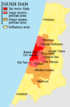 Cairt o the Gush Dan
 -
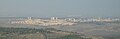
 Satellite Image o the Inner Ring o the Gush Dan
 -
-

-

-

-
 Tel Aviv beach


Metropolitan rings[eedit | eedit soorce]
Israel Central Bureau o Statistics divides the Tel Aviv metropolitan aurie intae fower:
| Metropolitan ring | Localities | Population (2009 census) | Population density (per km²) |
Annual Population growthe rate | |||
|---|---|---|---|---|---|---|---|
| Tot | Jews an ithers1 | Jews | Arabs | ||||
| Core2 | 1 | 392,500 | 375,100 | 358,600 | 17,300 | 7,576.6 | 0.6% |
| Inner Ring3 | 13 | 834,600 | 833,600 | 787,900 | 1,000 | 6,931.7 | 1.0% |
| Northren Section | 4 | 125,100 | 125,000 | 121,500 | 100 | 2,936.9 | 1.0% |
| Eastren Section | 5 | 398,800 | 398,600 | 388,100 | 200 | 9,921.1 | 1.3% |
| Soothren Section | 4 | 310,600 | 310,000 | 278,300 | 700 | 8,261.5 | 0.5% |
| Middle Ring4 | 31 | 1,004,400 | 971,400 | 923,300 | 33,000 | 3,452.6 | 1.7% |
| Northren Section | 6 | 205,200 | 205,000 | 199,400 | 200 | 3,922.9 | 1.3% |
| Eastren Section | 8 | 258,500 | 258,400 | 243,000 | 100 | 3,790.0 | 2.5% |
| Soothren Section | 17 | 540,700 | 508,000 | 480,800 | 32,700 | 3,175.0 | 1.5% |
| Ooter Ring5 | 206 | 975,100 | 863,400 | 826,400 | 111,600 | 929.0 | 2.6% |
| Northren Section | 95 | 406,300 | 324,600 | 311,200 | 81,600 | 1,051.2 | 2.2% |
| Eastren Section | 47 | 225,400 | 195,800 | 193,900 | 29,600 | 802.0 | 3.9% |
| Soothren Section | 64 | 343,300 | 343,000 | 321,300 | 400 | 898.8 | 2.2% |
| Tot | 251 | 3,206,400 | 3,043,500 | 2,896,200 | 163,000 | 2,119.7 | 1.7% |
Notes
- 1 The population o "Jews an others" includes Israeli Jews, non-Arab Christians an those no clessifee'd bi religion.
- 2 The core aurie includes the ceety o Tel Aviv.
- 3 The inner ring includes the ceeties Bat Yam, Holon, Ramat HaSharon, Ramat Gan, Giv'atayim, Bnei Brak, Herzliya, Or Yehuda, Giv'at Shmuel an Kiryat Ono, as well as a multitude o smawer towns (local cooncils).
- 4 The middle ring includes the ceeties Petah Tikva, Ra'anana, Rishon LeZion, Hod HaSharon, Kfar Saba, Yehud, Ramla, Lod, Rosh HaAyin, Ness Ziona an Rehovot, as well as mony smawer touns (local cooncils).
- 5 The ooter ring includes the ceeties Tayibe, Netanya, Modi'in-Maccabim-Re'ut, Ashdod , as well as mony smawer touns (local cooncils).

References[eedit | eedit soorce]
- ↑ "לוח 3.- אוכלוסייה( 1), ביישובים שמנו מעל 2,000 תושבים( 2) ושאר אוכלוסייה כפרית POPULATION(1) OF LOCALITIES NUMBERING ABOVE 2,000 RESIDENTS(2) AND OTHER RURAL POPULATION" (PDF). Retrieved 25 Januar 2010. Cite journal requires
|journal=(help) - ↑ http://www.cbs.gov.il/shnaton60/st02_16.pdf
- ↑ a b "Localities, Population, and Density" (PDF). Retrieved 24 Januar 2010.
- ↑ http://www.cbs.gov.il/population/new_2010/table3.pdf
| Wikimedia Commons haes media relatit tae Gush Dan. |