
Gedera
Gedera
| |
|---|---|
| Ebreu transcription(s) | |
| • ISO 259 | Gdera |
| • An aa spelled | Gdera, Gadera (unoffeecial) |
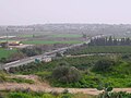
 View o Gedera frae Tel Qatra | |
 Gedera | |
| Coordinates: 31°48′58.66″N 34°46′37.23″E / 31.8162944°N 34.7770083°ECoordinates: 31°48′58.66″N 34°46′37.23″E / 31.8162944°N 34.7770083°E | |
| Destrict | Central |
| Foondit | 1884 |
| Govrenment | |
| • Teep | Local cooncil |
| • Head of Municipality | Yoel Gamliel |
| Area | |
| • Total | 14.5 km2 (5.6 sq mi) |
| Population (2015)[1] | |
| • Total | 26,217 |
| • Density | 1,800/km2 (4,700/sq mi) |
| Name meanin | Sheepfold [2] |
Gedera, or Gdera (Hebrew: גְּדֵרָה) is a toun in the Center Destrict o Israel. It is locatit 28 km sooth-east o Tel Aviv an 12 km east o Ashdod.
History[eedit | eedit soorce]
Gedera wis foondit in 1884 bi members o the Bilu group, near the ruins o a biblical Israelite ceety. Those ruins wur thocht tae hae been the ruins o a biblical ceety cried HaGdera[3] (The fenced ceety)(Joshua 15:36) or accordin tae anither, less probable theory o a biblical ceety cried Gderot (fences)(Joshua 15:41), an therefore the name Gedera (Fenced ceety) wis chosen.
Recent excavations in the Gedera aurie o Tel Qatra hae revealed airtifacts frae the Middle Bronze Age, Late Bronze Age, an Iron Age. In addition, remains o a mair recent Muslim cemetery hae been foond.
Up till the 1948 War o Unthirldom Gedera wis flanked bi the Arab Muslim veelage o Kfar Qatra, which wis situatit directly next tae the oreeginal Gedera hames. The majority o the residents o the veelages war expelled durin the war, niver tae return, an thair locations hae nou been biggit ower in the northren hauf o Gedera, primarily in the first 25 years efter the War o Unthirldom.
In the 1940s Idi Amin lived in Gedera for aroond a year as he received military trainin.
Geography an demographics[eedit | eedit soorce]
Gedera is biggit on 7 hills in the Shephelah, which rise tae the heicht o 80 meters abuin sea level. It haes an aurie o 14,500 dunams (14.5 km²) an a population o 21,500 at the end o 2009.[4] Gedera's Per Capita GDP as o a 2005 wis 35,573 NIS, or 9,321 US Dollars. In its history it haes aaways been a sma veelage, no bordered bi ony ither veelages o considerable size, an it is an aa mony miles away frae the suburbs o Tel Aviv, allouin it tae remain relatively sma an rural, servin as ane o the last stops for drivers enterin the Negev Desert.
It is famous for its pastoral countryside view. Surroondit bi green hills an agricultural lands, on the wast it is possible tae see aw the way tae the coastal ceety o Ashdod 14 kilometers tae the soothwast, an on the east thare is a clear view o the Judean Muntains an Jerusalem Muntains, an due tae the near proximity tae the border, an aa on a clear day intae the Wast Bank 25 kilometers tae the northeast.
Gedera is aften considered tae be the soothren edge o central Israel, while Hadera is considered the northren edge, hence the Israeli expression "frae Hadera tae Gedera" tae describe the maist populatit aurie in Israel.
Gedera haes a vera lairge population o Yemenite Jews that came afore an durin the foondin o the naition aroond the time o the War o Unthirldom. Maist estimates put thair population at 50% o Gedera, makin it ane o the few primarily Mizrahi touns in the center destrict o Israel.
Ower the past 15 years, Ethiopian Jews hae steadily muived tae Gedera, nou makin up a 16% o the population (3,200 fowk). Thair economic condeetion is impruivin, as the younger generation haed adaptit tae Israeli cultur an the leid, whauras the aulder immigrants hae no.
Expansion an development in the 2000s[eedit | eedit soorce]
Gedera's poseetion near the lairge sooth-central ceeties o Israel (Rehovot, Ashdod an Kiryat Gat), law prices for private hames an the fact that it is a green an quiet toun yet it is in the central destrict near Tel Aviv an Jerusalem mak it vera attractive tae Israelis. Gedera is ane o the faster-growin touns in Israel, wi a 7.9% growth rate. Recently, major developments hae taken place in ane section, creatin a hoosin development for well-tae-dae an middle class residents, simply cried New Gedera.
This major development, fundit an biggit bi the Azorim company, is an agglomeration o new close-knit houses-filled neighborhuids an law-rise apairtment biggins. The development haes expandit inhabitit Gedera bi a lairge degree an addit key services (banks, restaurants, shoppin locations an a planned movie theatre). A major shoppin venue biggit bi Azorim is the Gedera Mall, locatit in the sootheast o the toun. First opened in September 2007, Gedera Mall haes sma businesses alang wi anchor tenants frae semi-major depairtment stores frae Israel an Europe. Several restaurants are locatit athin the biggin, alang wi a sports complex that is possible tae expand in size dependin on future needs. The mall's size is seemilar tae maist in satellite ceeties in Israel, containin approximately 15 stores o varyin sizes. The mall haes twa floors, an covers hauf a ceety block in Gedera.
The major road Heich-gate 7 wis recently constructit alangside the border o Gedera, linkin Gedera directly tae Israel's cross-kintra heich-gate, Heich-gate 6.
Gallery[eedit | eedit soorce]
-
 Gedera
 -
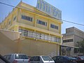 HaYafar Gedera supermercat, 2008
 -
 Local High School
 -
 Citie street in Gedera (2008)
 -
 Gan Roha kindergarden
 -
 North end.
 -
 Park next to Pines Elementary Schuil, 2008
 -
 Gedera 1935


.jpg)


.jpg)

References[eedit | eedit soorce]
- ↑ "List of localities, in Alphabetical order" (PDF). Israel Central Bureau of Statistics. Retrieved 16 October 2016.
- ↑ The Guide to Israel, Zev Vilnay, Jerusalem 1972, pp.254-256
- ↑ "Apparently site of Biblical Gederah" (Carta's Official Guide to Israel and Complete Gazetteer to all Sites in the Holy Land. (3rd edition 1993) Jerusalem, Carta, p.164, ISBN 965-220-186-3 (English))
- ↑ "Table 3 - Population of Localities Numbering Above 2,000 Residents" (PDF). Israel Central Bureau of Statistics. 2010-30-06. Retrieved 2010-10-30. Check date values in:
|date=(help)
Freemit airtins[eedit | eedit soorce]
| Wikimedia Commons haes media relatit tae Ge'dera. |
- Pictures o Gedera Archived 2011-05-19 at the Wayback Machine
- Toun's community wabsteid Archived 2008-05-31 at the Wayback Machine (in Ebreu)
- Gedera on Google Maps frae Space Archived 2011-12-27 at the Wayback Machine