Yesud HaMa'ala
This airticle needs mair soorces fur verification. |
Yesud HaMa'ala
| |
|---|---|
| Hebrew transcription(s) | |
| • ISO 259 | Ysud ha Maˁla |
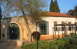
 Yesud HaMa'ala synagogue | |
| Coordinates: 33°3′22.22″N 35°36′14.66″E / 33.0561722°N 35.6040722°ECoordinates: 33°3′22.22″N 35°36′14.66″E / 33.0561722°N 35.6040722°E | |
| Destrict | Northren |
| Govrenment | |
| • Teep | Local cooncil |
| Area | |
| • Total | 11.587 km2 (4.474 sq mi) |
| Population (2008)[1] | |
| • Total | 1,354 |
| • Density | 120/km2 (300/sq mi) |
Yesud HaMa'ala is a toun in the Northren Destrict o Israel. It wis the first modren Jewish commonty in the Hula Valley. Built in 1882, the commonty wis amang a series o agricultural settlements foondit durin the First Aliyah. [2] The name o the veelage wis taken frae a sentence in the Bible: "He (Ezra) determined tae go up." (Ezra 7:9), which wis connectit tae the Zionist Aliyah.[citation needit]
Geografie
[eedit | eedit soorce]In the late 19t century, the Hulah Valley wis maistly swampland an the 15,000 acre (61 km²) shallae Lake Hula. The region wis a well-kent breedin grund for mosquitoes, an as a result concerns aboot malaria restrictit further Jewish settlement in the region for fifty years. As drainage technologie an pesticide uise increased in the 1920s, settlement in the aurie became mair feasible.[citation needit]
Hula drainage program
[eedit | eedit soorce]Efter the 1948 Arab-Israeli War an the establishment o the state o Israel, the swamp wis drained an convertit intae agricultural laund. Recognisin the unique ecoseestem o the valley an its importance as a stopower for migratin birds, scientists lobbiet for a sma portion o the swamp tae remain as a natur reserve. In 1964, the 800 acre (3.2 km²) Hula Valley Natur Reserve, the kintra's first, wis opened.[citation needit]
Arab-Israeli conflict
[eedit | eedit soorce]Wi the activation o the National Water Carrier in 1964, Sirie efforts tae disrupt drainage patterns intae the Sea o Galilee wur accompaniet bi attacks against Israeli fermin an fishin activities in the region. Three years later, Sirie forces wur repelled further frae Yesud HaMa'ala wi the captur o the Golan Hichts durin the 1967 Sax-Day War.[citation needit]
On 22 Julie 2006, a series o Katyusha attacks bi Hezbollah struck commonties in the Hulah Valley durin the course o the 2006 Lebanon War. In Yesud HaMa’ala, ane person wis lichtly woondit frae rocket shrapnel. Prior tae the bombins, the commonty haed no seen ony hostile attacks syne the Sax-Day War in 1967. On 29 Julie three rockets hit Yesud HaMa'ala, lichtly woondin a wumman an damagin property.[citation needit]
Landmarks
[eedit | eedit soorce]Yesud HaMa'ala is hame tae the Dubrovin Ferm, a museum commemoratin the foonders o the commonty, containin personal possessions an furnitur frae 19t century Roushie. Pairt o the museum includes ruins o a synagogue datin atween the 4t an 6t centuries, heichlichtin the historic Jewish claim tae the region.[citation needit]
References
[eedit | eedit soorce]| Wikimedia Commons haes media relatit tae Yesod HaMa'ala. |
- ↑ "Locality File" (XLS). Israel Central Bureau of Statistics. 2008. Retrieved 22 Juin 2010.
- ↑ "Archived copy". Archived frae the original on 30 August 2008. Retrieved 5 November 2012.CS1 maint: archived copy as title (link)


