Rishon LeZion
Appearance
Rishon LeZion | |
|---|---|
| Hebrew transcription(s) | |
| • ISO 259 | Riˀšon l Çiyon |
| • Transleet. | Rishon LeTziyon |
| • Forby spelt | Rishon LeZiyyon (offeecial) |
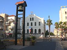
 Rishon LeZion skyline and lake | |
| Coordinates: 31°57′N 34°48′E / 31.950°N 34.800°ECoordinates: 31°57′N 34°48′E / 31.950°N 34.800°E | |
| Destrict | Central |
| Foondit | 1882 |
| Govrenment | |
| • Teep | Ceety (frae 1950) |
| • Mayor | Dov Tzur |
| Area | |
| • Total | 58.704 km2 (22.666 sq mi) |
| Population (2015)[1] | |
| • Total | 243,973 |
| • Density | 4,200/km2 (11,000/sq mi) |
| Name meanin | First tae Zion |

Rishon LeZion (Hebrew: רִאשׁוֹן לְצִיּוֹן ![]() (audio) (help·info), lit. First tae Zion), is the fowert-lairgest ceety in Israel, locatit alang the central Israeli coastal plain 12 kilometers sooth o Tel Aviv. It is pairt o the Gush Dan metropolitan aurie. In 2015 it haed a population o 243,973. Foondit in 1882 bi European Jewish immigrants, it wis the seicont Jewish farm colony established in Land o Israel in the 19t century, efter Petah Tikva.
(audio) (help·info), lit. First tae Zion), is the fowert-lairgest ceety in Israel, locatit alang the central Israeli coastal plain 12 kilometers sooth o Tel Aviv. It is pairt o the Gush Dan metropolitan aurie. In 2015 it haed a population o 243,973. Foondit in 1882 bi European Jewish immigrants, it wis the seicont Jewish farm colony established in Land o Israel in the 19t century, efter Petah Tikva.
Etymology
[eedit | eedit soorce]The name Rishon LeZion is derived frae a biblical verse: "First tae Zion are they, an A shall give herald tae Jerusalem" (Hebrew: ראשון לציון הנה הינם, ולירושלים מבשר אתן) (Book of Isaiah 41:27) an literally translates as the First tae Zion.
Twin touns — Sister ceeties
[eedit | eedit soorce]
|
References
[eedit | eedit soorce]- ↑ "List of localities, in Alphabetical order" (PDF). Israel Central Bureau of Statistics. Retrieved 16 October 2016.
- ↑ a b http://www.um.lublin.eu/en/index.php?t=200&id=40896 Archived 2009-04-23 at the Wayback Machine
- ↑ "Choose your family, Haaretz". Archived frae the original on 13 Apryle 2008. Retrieved 20 Januar 2011.
| Wikimedia Commons haes media relatit tae Rishon LeZion. |


