Olsztyn
Olsztyn | |
|---|---|
 Auld Toun | |
| Motto(s): Olsztyn – Miasto Młode Duchem… (Olsztyn– ceety o a young spirit…) | |
| Coordinates: 53°47′N 20°30′E / 53.783°N 20.500°E | |
| Kintra | |
| Voivodeship | Warmie-Masurie |
| Coonty | ceety coonty |
| Established | 14t century |
| Toun richts | 1353 |
| Govrenment | |
| • Mayor | Piotr Grzymowicz |
| Area | |
| • City | 88.328 km2 (34.104 sq mi) |
| Highest elevation | 154 m (505 ft) |
| Lowest elevation | 88 m (289 ft) |
| Population (2009) | |
| • City | 176,387 |
| • Density | 2,000/km2 (5,200/sq mi) |
| • Metro | 270,000 |
| Time zone | UTC+1 (CET) |
| • Summer (DST) | UTC+2 (CEST) |
| Postal code | 10-001 to 11–041 |
| Area code(s) | +48 89 |
| Caur plates | NO |
| Website | http://www.olsztyn.eu |

Olsztyn (Pols pronunciation: [ˈɔl.ʂtɨn] (![]() listen); German: Allenstein, [ˈalənʃtaɪ̯n]; Auld Pols: Holstin; Auld Proushian: Alnāsteini; Lithuanian: Olštynas) is a ceety on the Łyna River in northeastren Poland. Olsztyn haes been the caipital o the Warmie-Masurie Voivodeship syne 1999. It wis previously in the Olsztyn Voivodeship (an in ither units in 1945–75 an 1975–98). The ceety haes coonty status.
listen); German: Allenstein, [ˈalənʃtaɪ̯n]; Auld Pols: Holstin; Auld Proushian: Alnāsteini; Lithuanian: Olštynas) is a ceety on the Łyna River in northeastren Poland. Olsztyn haes been the caipital o the Warmie-Masurie Voivodeship syne 1999. It wis previously in the Olsztyn Voivodeship (an in ither units in 1945–75 an 1975–98). The ceety haes coonty status.
History
[eedit | eedit soorce]In 1346 the auld Posuhie Warmie forest in the vicinity wis cleared an a place wis selectit on the Alle, nou Łyna River, for a new settlement. The Teutonic Knichts began the construction o Ordensburg castle in 1347 as a stranghauld against the Auld Proushies, an the settlement o Allenstein wis first mentioned the follaein year. The German name Allenstein meant a castle on the Alle River. It became kent in Pols transliteration as Olsztyn. The settlement receivit municipal richts frae Johannes von Leysen on 31 October 1353, an the castle wis completit in 1397. Allenstein wis incorporatit intae the Kinrick o Poland durin the Pols-Lithuanie-Teutonic War in 1410 an in 1414 durin the Hunger War, but wis returned tae the monastic state o the Teutonic Knichts efter hostilities endit.
Allenstein joined the Proushie Confederation in 1440. It rebelled against the Teutonic Knichts in 1454 upon the ootbreak o the Thirteen Years' War an requestit protection frae the Pols Croun. Although the Teutonic Knichts captured the toun in the follaein year, it wis retaken bi Pols troops in 1463. The Seicont Peace o Thorn (1466) allocatit Allenstein an the Bishopric o Warmie as pairt o Ryal Proushie unner the sovereignty o the Croun o Poland. Frae 1516–21, Nicolaus Copernicus livit at the castle as admeenistrator o Allenstein an Mehlsack (Pieniężno); he wis in chairge o the defenses o Allenstein an Warmie durin the Pols-Teutonic War o 1519–21.
Allenstein wis sacked bi Swadish troops in 1655 an 1708 durin the Pols-Swadish wars, an the toun's population wis nearly wipit oot in 1710 bi epidemics o bubonic plague an cholera.
Allenstein wis annexed bi the Kinrick o Proushie in 1772 durin the First Pairtition o Poland. A Proushie census recordit a population o 1,770 fowk, predominantly fermers, in Allenstein, which wis admeenistered athin the Province o East Proushie. It wis visitit bi Napoleon Bonaparte in 1807 efter his victories ower the Proushie Airmy at Jena an Auerstedt. In 1825 the ceety wis inhabitit bi 1266 Poles an 1341 Germans[1] The German leid newspaper, Allensteiner Zeitung, wis first published in 1841. The toun hospital wis foondit in 1867.

Allenstein became parit o the German Empire in 1871 durin the Proushie-led unification o Germany. Twa years later the ceety wis connectit bi railwey tae Thorn (Toruń). Its first Pols leid newspaper, the Gazeta Olsztyńska, wis foondit in 1886. Allenstein's infrastructur developit rapidly: gas wis instawed in 1890, telephones in 1892, public watter supply in 1898, an electricity in 1907. The ceety became the caipital o Regierungsbezirk Allenstein, a govrenment admeenistrative region in East Proushie, in 1905. Frae 1818–1910 the ceety wis admeenistered athin the East Proushie Allenstein Destrict, efter which it became an independent ceety.
Shortly efter the ootbreak o Warld War I, truips o the Roushie Empire captured Allenstein in 1914, but it wis recovered bi the Imperial German Airmy in the Battle o Tannenberg. The battle actually teuk place hintle closer tae Allenstein than Tannenberg (nou Stębark), but the victorious Germans, haein been defeatit in the medieval battle o Tannenberg, namit it as such for propaganda purposes). In 1920 durin the East Proushie plebiscite, Allenstein votit tae remain in German East Prussia insteid o becomin pairt o the Seicont Pols Republic. The fitbaa club SV Hindenburg Allenstein played in Allenstein frae 1921 tae 45. Efter the Nazi seizur o power in 1933, Poles an Jews in Allenstein wur increasingly persecutit. In 1935 the Wehrmacht made the ceety the seat o the Allenstein Militärische Bereich. It wis the hame o the 11t Infanterie Diveesion, the 11t Airtillery Regiment, an the 217th Infanterie Diveesion.

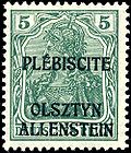
In 1920 a plebiscite wis held tae determine whether the ceety's populace wished tae remain in East Proushie or become pairt o Poland. In order tae advertise the plebiscite, special postage stamps wur producit bi owerprintin German stamps an sauld frae 3 Aprile. Ane kynd o overprint read PLÉBISCITE / OLSZTYN / ALLENSTEIN, while the ither read TRAITÉ / DE / VERSAILLES / ART. 94 et 95 inside an oval whose border gave the full name o the plebiscite commission. Each owerprint wis appleed tae 14 denominations rangin frae 5 Pf tae 3 M.
The plebiscite wis held on 11 Julie, an producit 362,209 votes (97.8 %) for East Proushie an 7,980 votes (2.2 %) for Poland. The stamps became invalid on 20 August. Despite their short period o uise, amaist aw o the stamps are cheaply available baith uised an unuised.
On 12 October 1939, efter the invasion o Poland that began Warld War II, the Wehrmacht established an Aurie Heidquairters for Wehrkreis I that controlled the sub-auries o Allenstein, Lötzen (Giżycko) an Zichenau (Ciechanów). Beginnin in 1939, members o the Pols-speakin minority, especially members o the Union o Poles in Germany, wur deportit tae Nazi concentration camps.
Allenstein wis plundered an burnt bi the invadin Soviet Red Airmy on 22 Januar 1945, as the Eastren Front reached the ceety. Allenstein's German population evacuatit the region or wur subsequently expelled. On 2 August 1945, the ceety wis placit unner Pols admeenistration bi the Soviets (accordin tae the Potsdam Greement) an offeecially renamit tae Pols Olsztyn. In October 1945, the German population o Olsztyn wis expelled bi Order o the Ceety Commanders o Olsztyn an ordered tae assemble on 18 October at Karl Roensch Street barracks camp for transfer tae Germany an in the case o nan-compliance wur tae be put in a "punishment camp".
A tyre factory wis foondit in Olsztyn in 1967.
Geografie
[eedit | eedit soorce]Locatit in the northeast pairt o Poland in the "Thoosans Lakes Aurie"
Green belt
[eedit | eedit soorce]Mair nor hauf o the forests occupeein 21.2 % o the ceety aurie form a single complex o the Municipal Forest (1050 ha) uised mainly for recreation an tourism purposes. Athin the Municipal Forest aurie are situatit twa peat-laund flora sanctuars, Mszar an Redykajny. Municipal greenery (560 ha, 6.5 % o the toun aurie) developit in the form of numerous pairks, green spots an three cemeteries ower a century-auld. The greenery includes 910 monuments o natur an groups o protectit trees in the form o beech, aik, maple an lime-lined avenues.
Lochs
[eedit | eedit soorce]The ceety is situatit in a loch region o forests an plains. There are 15 lochs inside the admeenistrative boonds o the ceety (13 wi auries greater than 1 ha). The oweraw aurie o lochs in Olsztyn is aboot 725 ha, which constitutes 8.25 % o the total ceety aurie.
| Loch | Aurie (ha) | Maximum depth (m) |
|---|---|---|
| Loch Ukiel (a.k.a. Jezioro Krzywe) | 412 | 43 |
| Loch Kortowskie | 89.7 | 17.2 |
| Loch Track (a.k.a. Jezioro Trackie) | 52.8 | 4.6 |
| Loch Skanda | 51.5 | 12 |
| Loch Redykajny | 29.9 | 20.6 |
| Loch Długie | 26.8 | 17.2 |
| Loch Sukiel | 20.8 | 25 |
| Loch Tyrsko (a.k.a. Jezioro Gutkowskie) | 18.6 | 30.6 |
| Loch Stary Dwór (a.k.a. Jezioro Starodworskie ) | 6.0 | 23.3 |
| Loch Siginek (a.k.a. Jezioro Kopytko, Jezioro Podkówka, Jezioro Styginek) | 6.0 | insufficient data |
| Loch Czarne | approximately 1.3 | insufficient data |
| Lake Żbik | approximately 1.2 | insufficient data |
| Loch Pereszkowo (a.k.a. Jezioro Pyszkowo) | approximately 1.2 | insufficient data |
| Loch Mummel (a.k.a. Jezioro Mumel) | approximately 0.3 | insufficient data |
| Loch Modrzewiowe | 0.25 | insufficient data |
Demografics
[eedit | eedit soorce]
| Year | Population |
|---|---|
| 1772 | 1,770 |
| 1846 | 4,000 |
| 1875 | 6,000 |
| 1885 | 11,555 |
| 1890 | 19,373 |
| 1895 | 25,000 |
| 1939 | 50,000 |
| 1941 | 54,300 |
| 1946 | 23,000 |
| 1950 | 45,000 |
| 1972 | over 100,000 |
| 1994 | 165,000 |
| 2000 | 170,000 |
| 2009 (30 Juin) | 176,387 |
Administrative diveesion
[eedit | eedit soorce]
Olsztyn is dividit intae 23 destricts:
| Destrict | Population | Aurie | Densitie |
|---|---|---|---|
| Brzeziny | 1,456 | 2.25 km² | 647.1/km² |
| Dajtki | 5,863 | 7.5 km² | 781.7/km² |
| Generałów | 6,500 | nae data | nae data |
| Grunwaldzkie | 6,027 | 1.46 km² | 4,128.1/km² |
| Gutkowo | 2,256 | 7.2 km² | 313.3/km² |
| Jaroty | 29,046 | 4.82 km² | 6,026.1/km² |
| Kętrzyńskiego | 7,621 | 4.83 km² | 1,577.8/km² |
| Kormoran | 16,166 | 1.1 km² | 14,696.4/km² |
| Kortowo | 1,131 | 4.22 km² | 268/km² |
| Kościuszki | 6,704 | 1.18 km² | 5,681.4/km² |
| Likusy | 2,286 | 2.1 km² | 1,088.6/km² |
| Mazurskie | 4,615 | 5.98 km² | 771.7/km² |
| Nad Jeziorem Długim | 2,408 | 4.23 km² | 569.3/km² |
| Nagórki | 12,538 | 1.69 km² | 7,418.9/km² |
| Pieczewo | 10,918 | 2.24 km² | 4,874.1/km² |
| Podgrodzie | 11,080 | 1.35 km² | 8,207.4/km² |
| Podleśna | 10,414 | 9.93 km² | 1,048.7/km² |
| Pojezierze | 13,001 | 2.39 km² | 5,439.7/km² |
| Redykajny | 1,555 | 6.1 km² | 254.9/km² |
| Śródmieście | 3,448 | 0.58 km² | 5,944.8/km² |
| Wojska Polskiego | 6,759 | 5.03 km² | 1,343.7/km² |
| Zatorze | 6,988 | 0.45 km² | 15,528.9/km² |
| Zielona Górka | 1,015 | 6.44 km² | 157.6/km² |
There are mony smawer destricts: Jakubowo, Karolin, Kolonia Jaroty, Kortowo II, Łupstych, Niedźwiedź, Piękna Góra, Podlesie, Pozorty, Skarbówka Poszmanówka, Słoneczny Stok, Stare Kieźliny, Stare Miasto, Stare Zalbki, Stary Dwór, Track. These dae no hae cooncil representative assemblies.
Cultur
[eedit | eedit soorce]Theatres
[eedit | eedit soorce]- Stefan Jaracz Theatre (est. 1925)
- Puppet Theatre
Cinemas
[eedit | eedit soorce]Museums
[eedit | eedit soorce]Olsztyn's lairgest museum is the Museum o Warmie an Mazury. The ceety haes the Gazeta Olsztyńska House, Museum o Natur, an Museum o Sports.
Airchitectur
[eedit | eedit soorce]
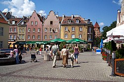
- The Auld Toun
- The Gothic castle o the Bishopric o Warmie built durin the 14t century.
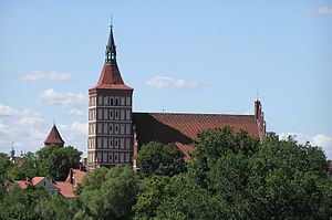
- St. James's Cathedral (Pols: św. Jakuba, German: St. Jacob or St. Jakob).
- Auld Toun Haw on the Market Square – built in mid-14t century.
- Gazeta Olsztyńska House at Fish Mercat.
- The toun waws an the Upper Gate (syne the mid-19t century kent as the Heich Gate).
- Neogothic kirk o the Holy Hert o Jesus, built durin the years 1901–1902
- The New Ceety Haw
- The Railway Bridge ower the River Łyna gorge near Artyleryjska an Wyzwolenia streets, built durin the years 1872–1873
- The Jerusalem Chapel, built in 1565
- Kirk o St. Lawrence, built durin the late 14t century
- FM- and TV-mast Olsztyn-Pieczewo – 360 metres heich, syne the collapse o the Warsaw radio mast the tawest structur in Poland
Music
[eedit | eedit soorce]Daith metal act Vader, regardit as ane o the first daith metal baunds frae Poland.
Economy
[eedit | eedit soorce]The Michelin tyre company (umwhile Stomil Olsztyn) is the lairgest employer in the region o Warmie an Masurie.[2] Ither important industries are fuid processin an furnitur manufacturin.
Unemployment
[eedit | eedit soorce]Olsztyn- 4,000 (fowk) – 4.8% rate
Education
[eedit | eedit soorce]
- University of Warmia and Mazury [1] Archived 2006-05-26 at the Wayback Machine
- University of Computer Science and Economics
- Olsztyńska Szkoła Wyższa im. Józefa Rusieckiego
- Olsztyńska Wyższa Szkoła Informatyki i Zarządzania im. Tadeusza Kotarbińskiego
- Wyższe Seminarium Duchowne HOSIANUM Archived 2012-07-16 at the Wayback Machine
- Masurian Institute (est. 1943)
Sport
[eedit | eedit soorce]- Indykpol AZS Olsztyn – men's volleybaw team playin in Polish Volleyball League (PLS, Polska Liga Siatkówki)
- OKS 1945 Olsztyn – men's fitbaw team, (8 saisons in Pols Ekstraklasa as Stomil Olsztyn)
- Warmia Traveland Olsztyn – men's handbaw team playin in Seria A (Pols First League)
- AZS UWM Trójeczka Olsztyn – men's basketbaw team playin in Pols Seicont League
- WMPD Olsztyn – men's rugby team, playin in First Pols League
- Budowlani Olsztyn Warstlin team
Politics
[eedit | eedit soorce]Members o the Sejm electit frae Olsztyn constituency in 2005
- Mieczysław Aszkiełowicz, Sel-Defense o the Republic o Poland (Samoobrona Rzeczypospolitej Polskiej)
- Beata Bublewicz, Civic Platform (PO, Platforma Obywatelska)
- Jerzy Gosiewski, Law and Justice (PiS, Prawo i Sprawiedliwość)
- Tadeusz Iwiński, Democratic Left Alliance (SLD, Sojusz Lewicy Demokratycznej)
- Edward Ośko, League o Pols Faimilies (LPR, Liga Polskich Rodzin)
- Adam Puza, Law an Justice (PiS, Prawo i Sprawiedliwość)
- Sławomir Rybicki, Civic Platform (PO, Platforma Obywatelska)
- Lidia Staroń, Civic Platform (PO, Platforma Obywatelska)
- Aleksander Marek Szczygło, Law and Justice (PiS, Prawo i Sprawiedliwość)
- Zbigniew Włodkowski, Polish Peasant Party (PSL, Polskie Stronnictwo Ludowe)
Members o Senate electit frae Olsztyn constituency in 2005
- Ryszard Józef Górecki, Civic Platform (PO, Platforma Obywatelska)
- Jerzy Szmit, Law an Justice (PiS, Prawo i Sprawiedliwość)
Internaitional relations
[eedit | eedit soorce]
Twin towns – Sister ceeties
[eedit | eedit soorce]Olsztyn is twinned wi:
|
'*
|
|
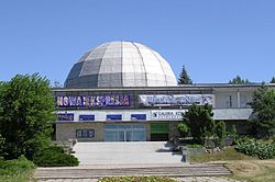
Olsztyn belangs tae the Federation o Copernicus Ceeties, an association o ceeties whare Copernicus livit an wirkit, such as Bologna, Frombork, Kraków, an Toruń. The main office o the federation is situatit at Olsztyn Planetarium an Astronomical Observatory, locatit on St. Andrew's Hill (143 m) in a umwhile watter touer erectit in 1897.
References
[eedit | eedit soorce]- ↑ Historia Pomorza:(1815-1850),Gerard Labuda, Poznańskie Towarzystwo Przyjaciół Nauk,page 157, 1993
- ↑ "100-milionowa opona w olsztyńskiej fabryce Michelin – Autoflesz.pl – Niezależny Portal Motoryzacyjny". Autoflesz.pl. Archived frae the original on 21 Mey 2014. Retrieved 16 September 2011.
- ↑ "List of Twin Towns in the Ruhr District" (PDF). 2009 Twins2010.com. Archived frae the original (PDF) on 28 November 2009. Retrieved 28 October 2009. freemit airtin in
|publisher=(help) - ↑ "Bielsko-Biała – Partner Cities". 2008 Urzędu Miejskiego w Bielsku-Białej. Retrieved 10 December 2008.
| Wikimedia Commons haes media relatit tae Olsztyn. |
- (in Pols) http://www.olsztyn.eu/
- (in Pols) http://www.bezrobocie.net/stat_powiaty.php/ Archived 2014-09-04 at the Wayback Machine
- [2] Archived 2010-02-20 at the Wayback Machine (pols)
- [3] Archived 2012-03-08 at the Wayback Machine (pols)
Freemit airtins
[eedit | eedit soorce]- Offeecial wabsteid Archived 2015-02-15 at the Wayback Machine (in Inglis)
- Olsztyn Ceety Guide Archived 2012-05-08 at the Wayback Machine (in Inglis)


