Jomala
Jomala | |
|---|---|
Municipality | |
| Jomala kommun | |
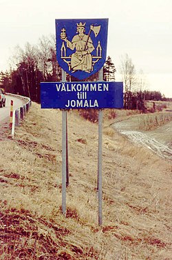
 Walcome tae Jomala! The coat o airms o Jomala featurs St. Olav sittin on a throne an hauldin an axe an a globus cruciger | |
 Location o Jomala in Finland | |
| Coordinates: 60°09′N 019°57′E / 60.150°N 19.950°ECoordinates: 60°09′N 019°57′E / 60.150°N 19.950°E | |
| Kintra | |
| Region | Åland |
| Sub-region | Åland Kintraside sub-region |
| Govrenment | |
| • Municipal manager | Carolina Sandell |
| Area (2018-01-01)[1] | |
| • Total | 687.00 km2 (265.25 sq mi) |
| • Laund | 142.53 km2 (55.03 sq mi) |
| • Water | 544.43 km2 (210.21 sq mi) |
| Area rank | 282nt lairgest in Finland |
| Population (2023-02-28)[2] | |
| • Total | 5,624 |
| • Rank | 162nt lairgest in Finland |
| • Density | 39.46/km2 (102.2/sq mi) |
| Population bi native leid | |
| • Swedish | 92.1% (offeecial) |
| • Finnish | 4.7% |
| • Ithers | 3.2% |
| Population by age | |
| • 0 tae 14 | 20.6% |
| • 15 tae 64 | 67.1% |
| • 65 or aulder | 12.3% |
| Time zone | UTC+2 (EET) |
| • Summer (DST) | UTC+3 (EEST) |
| Website | www.jomala.ax |
Jomala is a municipality o Åland, an autonomous territory o Finland.
The municipality haes a population o 5,624 (28 Februar 2023)[2] an covers an aurie o 687.00 square kilometre (265.25 sq mi) o which 544.43 km2 (210.21 sq mi) is watter.[1] The population densitie is 39.46 inhabitants per square kilometre (102.2/sq mi).
The municipality is unilingually Swadish.
Mariehamn Airport is locatit in Jomala.
History
[eedit | eedit soorce]It is no kent whaur the name Jomala comes frae but it haes been suggestit that "jom" comes frae the name o the Viking god Jom an "ala" means "place". Tharefore Jomala wad mean "the place whaur Jom is worshipit".
Housomeivver, "Jomala" is the name o a god common tae mony Finno-Ugric fowks.
Jomala wis inhabitit aroond 2000 B.C wi Jettböle bein ane o the maist renouned prehistoric steids. Ither auncient steids include Borgberget whaur thare wis a Viking fortress an Kasberget which wis ane o the mony muntains whaur signal fires wur lit whan enemies wur seen approachin.
Afore the ceety o Mariehamn wis established in 1861, the peninsulae whaur the ceety is situatit wis a pairt o Jomala.
Sichts
[eedit | eedit soorce]

The kirk of Jomala is dedicated tae the patron saint of Åland, St. Olav. It is the auldest stone kirk in Åland an it is situated in the veelage of Prästgården. The auldest pairts o the kirk date frae the 12t century. The kirk touer is 52 meters taw an thare is an aa a memorial for aw the Ålanders who hae moved away. The "King of Åland" Julius Sundblom is buried here. In the auld times thare wis a great estate on the eastren side o the kirk.
The Lemström channel divides Jomala frae its neighboring municipality, Lemland. It wis widened bi Roushie POWs in 1882.
The Kungsö battery wis ane o the ten coastal batteries which the Roushies biggit in Åland during the First World War in 1916. The battery wis situated 32 meters abuin sea level, on the heichest pynt of Dalsberg. Finnish, Swedish an German troops invaded it in 1918. It wis dismantled in 1919 bi Finnish civilian workers.
Cultur
[eedit | eedit soorce]Syne Jomala belangs tae the Swadish-speakin auries o Finland, Midsimmer is celebratit ivery year bi hoistin up a maypole. It wis a tribute tae the sun in the auncient times. Hairst festivities are held ivery September.
Geografie
[eedit | eedit soorce]Jomala is bordered bi Lemland in the soothwast, Mariehamn in the sooth, Hammarland in the northwast, Finström in the north an Sund in the northeast.
Veelages
[eedit | eedit soorce]Andersböle, Björsby, Buskböle, Dalkarby, Djurvik, Gottby, Gölby, Hammarudda, Hinderböle, Ingby, Jomalaby, Karrböle, Kila, Kungsöby, Möckelby, Möckelö, Norrsunda, Rasmansböle, Ringsböle, Sviby, Södersunda, Torp, Ulvsby, Vargsunda, Västansunda, Västerkalmar, Ytterby, Ytternäs, Ödanböle, Önningeby, Österkalmar, Överby.
Fowk frae Jomala
[eedit | eedit soorce]- Janne Holmén, lang distance runner, European champion in men's marathon
- Maria Jonsson, three-time Miss Swaden winner, 1991-1993
- Simon Holmström, young politeecian, chairman o a poleetical group for young fowk
References
[eedit | eedit soorce]- ↑ a b "Area of Finnish Municipalities 1.1.2018" (PDF). National Land Survey of Finland. Retrieved 30 Januar 2018.
- ↑ a b "Preliminar population structur bi aurie, 2022M01*-2023M02*". StatFin (in Finnish). Statistics Finland. Retrieved 4 Apryle 2023.
- ↑ "Population according to language and the number of foreigners and land area km2 by area as of 31 December 2008". Statistics Finland's PX-Web databases. Statistics Finland. Retrieved 29 Mairch 2009.
- ↑ "Population according to age and gender by area as of 31 December 2008". Statistics Finland's PX-Web databases. Statistics Finland. Retrieved 28 Apryle 2009.
- ↑ a b "Luettelo kuntien ja seurakuntien tuloveroprosenteista vuonna 2023". Tax Admeenistration o Finland. 14 November 2022. Retrieved 7 Mey 2023.
Freemit airtins
[eedit | eedit soorce]![]() Media relatit tae Jomala at Wikimedia Commons
Media relatit tae Jomala at Wikimedia Commons
- Municipality of Jomala Archived 2008-12-09 at the Wayback Machine – Offeecial wabsteid
- Map of Jomala municipality Archived 2012-02-05 at the Wayback Machine


