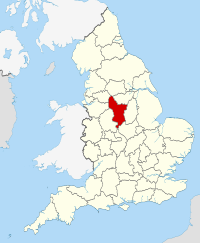
Derbyshire
Appearance

| |
| Geography | |
| Status | Ceremonial an (smawer) nan-metropolitan coonty |
|---|---|
| Region | East Midlands |
| Aurie - Total - Admin. council - Admin. aurie |
Rankit 21st 2,625 km2 (1,014 sq mi) Rankit 20t 2,547 km2 (983 sq mi) |
| Admin HQ | Matlock |
| ISO 3166-2 | GB-DBY |
| ONS code | 17 |
| NUTS 3 | UKF12/13 |
| Demographics | |
| Population - Total (2011 est.) - Density - Admin. council - Admin. pop. |
Ranked 19t 1,010,600 385/km2 (1,000/sq mi) Ranked 11t 763,700 |
| Ethnicity | 96.0% White 2.3% S. Asie 1.7% Black, Mixed Race or Cheenese |
| Politics | |
| Arms of Derbyshire County Council Derbyshire County Council http://www.derbyshire.gov.uk/ | |
| Executive | Conservative |
| Members o Parliament | |
| Destricts | |
 1. High Peak 2. Derbyshire Dales 3. Sooth Derbyshire 4. Erewash 5. Amber Valley 6. North East Derbyshire 7. Chesterfield 8. Bolsover 9. Derby (Unitary) | |
Derbyshire (![]() i/ˈdɑːrbᵻʃə/ DAR-bi-shər or /ˈdɑːrbɪʃɪər/ DAR-bi-sheer; abbreviatit Derbys. or Derbs.) is a coonty in the East Midlands o Ingland. A substantial portion o the Peak District National Park lees athin Derbyshire. The soothren extremity o the Pennine range o hills extends intae the north o the coonty. The coonty contains athin its boondary o approximately 225 mile pairt o the Naitional Forest. In 2003 the Ordnance Survey placit Church Flatts ferm, near Coton in the Elms, as the furthest point frae the sea in Great Breetain.[1][2]
i/ˈdɑːrbᵻʃə/ DAR-bi-shər or /ˈdɑːrbɪʃɪər/ DAR-bi-sheer; abbreviatit Derbys. or Derbs.) is a coonty in the East Midlands o Ingland. A substantial portion o the Peak District National Park lees athin Derbyshire. The soothren extremity o the Pennine range o hills extends intae the north o the coonty. The coonty contains athin its boondary o approximately 225 mile pairt o the Naitional Forest. In 2003 the Ordnance Survey placit Church Flatts ferm, near Coton in the Elms, as the furthest point frae the sea in Great Breetain.[1][2]
References
[eedit | eedit soorce]Freemit airtins
[eedit | eedit soorce]- Derbyshire at Curlie
