Nerkin Getashen
Nerkin Getashen | |
|---|---|
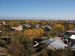
 The veelage o Nerkin Getashen, October 2009. | |
| Coordinates: 40°08′45″N 45°15′50″E / 40.14583°N 45.26389°E | |
| Kintra | Armenie |
| Province | Gegharkunik |
| Elevation | 1948 m (6,391 ft) |
| Population (2008) | |
| • Total | 7,614 |
Nerkin Getashen (Armenie: Ներքին Գետաշեն, Romanisit as Nerk’in Getashen, Nerkin Getachen, an Nerqin Getashen an aw - meanin "Lawer Getashen"; prior tae 1945, Nerkin Adyaman Nizhniy Adyaman - baith meanin "Lawer Adyaman") is a fishin veelage on the sooth coast o Lake Sevan in Gegharkunik, Armenie. In the early medieval it wis the caipital o the region kent durin that time as Kot.
In the veelage is the 9t century monastery an kirk o Kotavank owerleukin the veelage an the Argitchi River wi a muckle cemetery adjacent. Turkic rune inscriptions are locatit nearbi. Athin the veelage is a ruined basilica cried "Jam" bi the locals wi khachkars biggit intae its waws an aw, an no far awa is a sma shrine. Thare are twa muckle stane forts frae the Middle Ages locatit 2 km tae the east an 3 km the wast o the veelage.
Sooth o Nerkin Getashen lees Verin Getashen (upper Getashen), foondit 1828-29 bi migrants frae Mush an Alashkert.
Gallery
[eedit | eedit soorce]-
Kotavank an the adjacent cemetery.
References
[eedit | eedit soorce]- Nerkin Getashen at GEOnet Names Server
- World Gazeteer: Armenia[deid airtin] – World-Gazetteer.com
- Report of the results of the 2001 Armenian Census, Naitional Statistical Service o the Republic o Armenie
- Kiesling, Brady (2005), Rediscovering Armenia: Guide, Yerevan, Armenie: Matit Graphic Design Studio


