Jerash Govrenorate


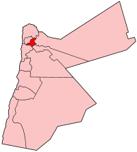
Jerash (Arabic: جرش) is ane o the govrenorates o Jordan; it is locatit north o Amman, Jordan's caipital. It carrys the name o its caipital an lairgest ceety, Jerash Ceety.
Jerash Govrenorate haes the smawest aurie o the 12 govrenorates o Jordan, yet it haes the seicont heichest density in Jordan efter Irbid Govrenorate. Jerash Govrenorate is ranked 7t bi population.[1]
Geography
[eedit | eedit soorce]
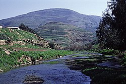
Jerash is a hilly region wi fertile lands, the province is bordered bi Irbid Govrenorate tae the north, Ajlun Govrenorate tae the wast, Mafraq Govrenorate an Zarqa Govrenorate tae the east, and Balqa Governorate frae the sooth. The Average yearly rainfall in Jerash govrenorate is in the range o 400–500 mm considered amang the heichest in the kintra.[2] The elevation range o the province is 300 tae 1300 m abuin sea level wi fresh water streams an the Zarqa River flowin through it, surroondit bi fertile plains, hills an muntains wi a mild mediterranean climate, flora an fauna.
Industry an Agricultur
[eedit | eedit soorce]Jerash is kent for its ample olive groves an fruit orchirds, amaist ane-fort o the total aurie o the province is covered wi olive groves some datin back tae the Roman times. Estimates put the number o olive trees in Jerash at 2 million trees. Jerash Governorate haes a total annual production o 6500 tonns o olives an 1300 tons o olive oil.[3]
The caipital ceety o the province, Jerash, is at an equidistance frae the three lairgest ceeties in Jordan, Amman, Irbid, an Zarqa (48 km frae Amman, 40 km frae Irbid, an 50 km frae Zarqa), this proximity proved tae be difficult for the ceety tae attract investments, as ivestors will tend tae invest in ane o those ceeties.

Veelages an Refugee Camps
[eedit | eedit soorce]Aside frae the ceety that gives the govrenorate its name, Jerash Govrenorate comprises 22 veelages, El-Kitté, Souf, Al-Haddadé, Sakeb, Bellila, Kufranjé, El-Hseiniat, Deir Il-Liyat, Al-Mastaba, Nahlé, Il-Kfeir, Bani Irsheid, Raimoun, An-Nabi Houd, Burma, Al-Jazzazah, Jubbah, Mirse', Muqbila, Al-Msheirfeh, Qafqafa an 2 Palestinian refugee camps, Souf camp an Jerash camp.
History
[eedit | eedit soorce]In the first century o the Christian era this insignificant ceety (then Gerasa) experienced a fast ascent unner Roman rule an the Pax Romana. It became pairt o the Decapolis an grew increasingly competitive wi the aulder Petra as a commercial toun. The inhabitants wan ore in the nearbi Ajlun muntains. Stairtin in the middle o the 1st century, this upswing led tae active biggin an a rich abundance o airchitectural monuments, still impressive today. In the 2nt century, the Roman expansion wars in Asie led tae further gains. Well-made roads wur built tae Pella, Philadelphia (nou Amman), Dion an tae the provincial caipital Bos(t)ra. Emperor Hadrian visitit the ceety in the winter o 129-130. In the follaein centuries the poleetical situation in this region chynged fundamentally an the ceety's means declined. Durin this time an aa Christianity wis on the ascendant an mony kirks wur built. Gerasa haed its awn bishop—still the day it is a Titularbistum—an bishop Placcus (or Plancus) participatit in the Cooncil o Chalcedon. Nicomachus of Gerasa came from this Gerasa.
References
[eedit | eedit soorce]- ↑ "DoS Jordan". Archived frae the original on 12 October 2017. Retrieved 2 Februar 2011.
- ↑ "Alrai Newspaper". Archived frae the original on 13 December 2009. Retrieved 2 Februar 2011.
- ↑ "Addustour Newspaper". Archived frae the original on 7 Julie 2011. Retrieved 2 Februar 2011.
Coordinates: 32°16′37″N 35°54′20″E / 32.2769°N 35.9056°E
| Wikimedia Commons haes media relatit tae Jerash. |
