
Eastriggs
| Eastriggs | |
|---|---|
 Eastriggs Location within Dumfries an Gallowa | |
| Population | 1,683 [1] (2001 census) est. 1,790[2] (2006) |
| OS grid reference | NY247662 |
| Cooncil area | |
| Lieutenancy area | |
| Kintra | Scotland |
| Sovereign state | Unitit Kinrick |
| Post toun | ANNAN |
| Postcode destrict | DG12 |
| Diallin code | 01461 |
| Police | Scots |
| Fire | Scots |
| Ambulance | Scots |
| EU Pairlament | Scotland |
| UK Pairlament | |
| Scots Pairlament | |
Eastriggs is a smaw veelage locatit in the historical coonty o Dumfriesshire in Dumfries an Gallowa, soothwast Scotland. The veelage is locatit aboot 2 mile north o the clartbaunks an the saundbanks o the chainel o the River Eden that stends wast intil the Solway Firth.
Traivelin bi road, Eastrigg is 3 mile til the east o Annan, 19 mile til the east o Dumfries, 5 mile til the wast o Gretna about 18 mile wast o Cairl an about 83 mile til the sooth o Edinburgh.
The B71 road rins throu Eastrigg an ither neebourin touns an veelages connectin til the nearby A75 road.
History
[eedit | eedit soorce]Situatit in the pairish o Dornock in the tradeetional coonty o Dumfriesshire, Eastriggs appears tae hae taen its name fae the ferm, or ferm hoose, kent as Eastriggs that wis locatit in mid o whit wis tae become the new sattlement.[3] The anely ither biggins in the aurie afore Warld War I wis a curn o hooses at Lowtherton (noo North Road, Lowtherton); a parpen curn on whit is noo the B721 road; an in an a smiddy whaur the East Road jynes the B721.[3]
The sattlement o Eastriggs wis creatit as an upshot o the Shell Creesis o 1915 that gart the newly foondit Meenistry o Munitions tae creaut a new cordite warks.[4]
Designatit offeecial HM Factory, Gretna, the warks wis spreid ower a 9-mile site streetchin fae Dornock throu Gretna tae Langtoon in Cumbria.[5] This require't a muckle influx o labour, an 30,000 men an weemen cam fae aw ower the Commonweel o Nations tae serve as biggin wirkers an factory wirkers.[6]

(demolisht in Mairch 2010)
Sir Raymond Unwin, the Chief Hoosin Airchitect o the hoosin brainch o the Explosives Depairtment o the Meenistry o Munitions, designt widden hoosin for the wirkers in baith Eastriggs an Gretna.[7] As a merk o respct for the immigrant wirkers, the streets wis name't efter various ceetys in the Commonweel.[6]
Governance
[eedit | eedit soorce]Eastriggs is in the UK pairlamentary constituency o Dumfriesshire, Clydesdale and Tweedale. David Mundell is the praisent Scots Conservative Pairty Member o Pairlament.
It is pairt o the Sooth Scotland region in the Scots Pairlament, bein in the constituency o Dumfriesshire. Oliver Mundell o the Scots Conservative Pairty is the MSP.
Afore Brexit, for the European Pairlament its residenters votit tae elect MEPs for the Scotland constituency.
Kirk o St John the Evangelist
[eedit | eedit soorce]
Designt in the Gothic style bi C M Crickmer unner the direction o Sir Raymond Unwin,[8] the Kirk o St John the Evangelist wis dedicatit in 197 an wis propine't wi a signt altar beuk the follaein year bi Keeng George V an Queen Mary that wis veesitin HM Factory, Gretna.
Rail transport
[eedit | eedit soorce]The Glasgow South Western Line connectin Cairl, Gretna Green, an Annan passes throu the praisently closed Eastriggs railwey station. This station is disuised, bit the're plans tae provide a smawer replacement on the line, that haes been upgradit fae single tae double track, enablin simultaenous passenger an fraucht traffeck.
References
[eedit | eedit soorce]- ↑ "Comparative Population Profile: Eastriggs Locality". Scotland's Census Results Online. 29 Apryle 2001. Archived frae the original on 19 Mey 2011. Retrieved 3 September 2008.
- ↑ Statistics from the gro-scotland.gov.uk site Archived September 16, 2009, at the Wayback Machine Retrieved on 3 September 2008
- ↑ a b Victorian OS Sheet 6
- ↑ Ministry of Munitions of War, Preface
- ↑ Ministry of Munitions of War, Chapter 2: Water Supply
- ↑ a b Longtown Military Railway
- ↑ Stratton & Trinder (2000)
- ↑ Scottish Churches Architectural Heritage Trust[deid airtin] Retrieved on 7 September 2008
Notes
[eedit | eedit soorce]- Reprinted one-inch Victorian Ordnance Survey Maps of Scotland (Sheet 6), Annan & Whithorn. 1st edition revised to 1896. Kyle of Lochalsh: Caledonian Maps. ISBN 1-85349-006-7.
- Ordnance Survey Landranger Map (number 85) - 1:50,000 scale (1.25 inches to 1 mile). ISBN 0-319-22685-9.
- Ordnance Survey Explorer Map (number 323) - 1:25,000 scale (2.5 inches to 1 mile)
- Ministry of Munitions of War, (1918). H.M. Factory, Gretna: Description of Plant and Process. Dumfries: J. Maxwell & Son for His Majesty's Stationery Office.
- Stratton, Michael and Trinder, Barrie (2000). Twentieth Century Industrial Archaeology. London: E & FN Spon. ISBN 0-419-24680-0.
- Video/DVD, (1994). The Longtown Military Railway. Carnfort
Gailerie
[eedit | eedit soorce]-
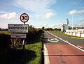 Eastriggs, The Commonweel Veelage, fae the east.
 -
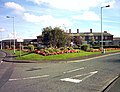 Eastriggs fae the wast
 -
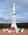 Dornock an Eastriggs war memorial


External links
[eedit | eedit soorce]| Wikimedia Commons haes media relatit tae Eastriggs. |
- Eastriggs Primary Schuil on annan.org.uk
- Eastriggs Primary Schuil on scottishschoolsonline.gov.uk[deid airtin]
| This Places o Scotland airticle is a stub. Ye can help Wikipaedia bi expandin it. |