
Bjni
Bjini Բջնի | |
|---|---|
 | |
 Bjini Բջնի | |
| Coordinates: 40°27′34″N 44°38′55″E / 40.45944°N 44.64861°E | |
| Kintra | Armenie |
| Province | Kotayk |
| First Mentioned | Ghazar Parpetsi |
| Govrenment | |
| • Mayor | Armen Matevosyan |
| Area | |
| • Total | 42.81 km2 (16.53 sq mi) |
| Elevation | 1550 m (5,090 ft) |
| Population (2008) | |
| • Total | 3,010 |
Bjni (Armenie: Բջնի; written Bjini or Bzhni an aw) is a veelage in the Kotayk Province o Armenie. It is situatit in a strath atween canyon waws an a smaw river. Throughoot Bjni's history, it haes remained ane o the main centers o education in Armenie. Some manuscripts frae Bjni datit tae the 12t tae 17t centuries hae survivit. The first recordit mention o the veelage wis bi the 5t tae 6t century chronicler an historian Ghazar Parpetsi.
Gallery
[eedit | eedit soorce]-
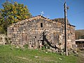
 Kirk o Saunt Sargis atop a stane ootcrop in the middle o the veelage east o the fortress.
 -
 The kirk o Surb Gevorg (S. George) biggit in the 13t c. sits just a couple hooses awa frae Bjni Kirk.
 -
 Remains o Bjni Fortress wi a medieval structur being rebiggit upon the plateau.


References
[eedit | eedit soorce]- Bjni at GEOnet Names Server
- Report of the results of the 2001 Armenian Census, Naitional Statistical Service o the Republic o Armenie
Freemit airtins
[eedit | eedit soorce]![]() Media relatit tae Bjni at Wikimedia Commons
Media relatit tae Bjni at Wikimedia Commons
- Kirk o Holy Virgin in Bjni (armenica.org)
- Kirk o St Sarkis in Bjni (armenica.org)
- Communities Association of Armenia: Bjni Archived 2011-07-06 at the Wayback Machine
- 3D model of Church of St Sarkis in Bjni[deid airtin]
- World Gazeteer: Armenia[deid airtin] – World-Gazetteer.com
