Ptghni
Ptghni | |
|---|---|
| Coordinates: 40°15′24″N 44°35′06″E / 40.25667°N 44.58500°E | |
| Kintra | Armenie |
| Marz (Province) | Kotayk |
| Foondit | 1831 |
| Govrenment | |
| • Mayor | Arakel Virabyan |
| Area | |
| • Total | 6.22 km2 (2.40 sq mi) |
| Elevation | 1350 m (4,430 ft) |
| Population (2008) | |
| • Total | 1,337 |
| Time zone | UTC+4 ( ) |
| • Summer (DST) | UTC+5 ( ) |
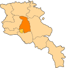
Ptghni (Armenie: Պտղնի, Romanisitd a Ptykhni, Ptgni, an Ptkhni an aw) is a veelage locatit in the Kotayk Province o Armenie alang the left bank o the Hrazdan River. It wis foondit in 1831 in the vicinity o an abandoned dwellin. The veelage haes a hoose o cultur, schuil, kindergarten, an a librar. Local inhabitants predominantly grow grapes, melons, gourds, an breed cattle.
Athin the veelage are the remains o fortress waws an Ptghavank o the 6t tae 7t century.
Gallery[eedit | eedit soorce]
-
Ptghavank
-
Khachkar monument beside the heich-gate leadin throu Ptghni.
References[eedit | eedit soorce]
- Ptghni at GEOnet Names Server
- World Gazeteer: Armenia[deid airtin] – World-Gazetteer.com
- Report of the results of the 2001 Armenian Census, Naitional Statistical Service o the Republic o Armenie
Freemit airtins[eedit | eedit soorce]
- Communities Association of Armenia: Ptghni Archived 2016-03-05 at the Wayback Machine


