
Troqueer
| Troqueer | |
|---|---|
 Troqueer Pairish Kirk | |
 Troqueer Location within Dumfries an Gallowa | |
| OS grid reference | NX976762 |
| Cooncil area | |
| Lieutenancy area | |
| Kintra | Scotland |
| Sovereign state | Unitit Kinrick |
| Post toun | DUMFRIES |
| Postcode destrict | DG1/2 |
| Diallin code | 01387 |
| Police | Scots |
| Fire | Scots |
| Ambulance | Scots |
| EU Pairlament | Scotland |
| UK Pairlament | |
| Scots Pairlament | |
Troqueer is an umwhile veelage an pairish in the historic coonty o Dumfriesshire in Dumfries an Gallowa, Scotland on the wast side o the River Nith.[1] The eastren-side o the veelage wis mellt wi Dumfries til the east in 1929, an nouadays eastren Troqueer is a suburb o Dumfries.
Location
[eedit | eedit soorce]Troqueer lies on the wast side o the River Nith, an wis oreeginal in Kirkcoubrieshire.[2] The pairish haes an aurie o 11,675 acre includin the umwhile burgh o Maxwelltoun in the nor'eastren airt.[3] It is abbot 7.5 mile fae north tae sooth, an 4.5 mile fae east tae wast, and is boondit on the east bi the River Nith.
An 1846 accoont said the pairish includit some wuidland an plantations, bit wis mainly arable launds, meidaes, and pasturs. The accoont conteenaed: "The surface is intersected by three nearly equidistant and parallel ranges of heights, the first of which, rising gradually from the river, has been long in a high state of cultivation, and contains several nursery grounds and gardens of great fertility. The valley between it and the second ridge is also fruitful, and is watered by the Cargen, which flows into the Nith. The second ridge, of greater elevation, produces excellent crops of turnips and potatoes, with wheat, barley, and oats; and the interval between it and the third ridge is partly good meadow land, but chiefly moss, which might at a moderate expense be brought into tillage. The third ridge, and the highest, extends through the whole length of the parish; it is arable on the acclivities nearly to the summit, and though less fertile than the others, yields remunerating crops. The Nith, of which the water is beautifully limpid, abounds with salmon, grilse, and herlings, even beyond what is necessary for the supply of the surrounding district. The plantations consist of oak, ash, elm, and other foresttrees, with fir and larch; they are carefully managed, and in a flourishing condition."[4]
Etymology
[eedit | eedit soorce]The name Troqueer is o Cumbric oreegin. The first element is treβ "fermtoun".[5] The seicont is likely *wejr "a bend, something bendit an twistit", referin til the bend in the River Nith aneath Troqueer Motte.[6] Andrew Breeze propones the meanin "fermtoun on the (river)-bend (jouk)".[5]
History
[eedit | eedit soorce]Thare is twa schedule't moniments in the pairish: Pecht's Knowe an Curriestanes cursus.[7][8]
In the 12t century Alan o Gallowa (afore 1199-1234, kent an aw as Alan fitz Roland), Constable o Scotland, built an yirdwark motte an bailey forteress, the Mote o Troqueer, again the banks o the Nith. In the early 13t century the fortress wis haudit bi Durand fitz Christin. Pairt o the flet-tappit motte survives, bit some o the motte is noo kivert bi the suburbs, and the poseetion o the bailey his been tyne't.
John Blackadder (c.1622-1685), the kenspeckle Covenanter, wis ordeent meenister o the Troqueer pairish on 7 Juin 1653 durin the time o the Commonwalth (1649-1660). Blackadder wis fleme't fae his pairish in 1662 efter the Restoration (or Relievin) of Charles II, Keeng o Scots acause he refuised tae complee wi the Episcopacy, that the government haed introduce't in Scotland.[9]
The community aroond the Troqueer pairish wis made a separate burgh o Maxwelltoun in 1810, wi its ain cooncil an coort.[2] In 1846 the pairish conteenin 4,351 woners, of that 3,230 wis in the burgh.[4] As o 1887 the pairish haed a populatioin o 5,524.[3] Durin the 19t century Maxwelltoun steidy growed as it acquire't tannages, a pundie-hoose, airn warks, weavin shaps, a brick an wilke warks, saw mills, an the Troqueer an Rosefield Mills. Maxwelltoun haed become the seicont-lairgest toun in Dumfries an Gallowa whan it mellt wi Dumfries on 3 October 1929.[10]
Nouadays
[eedit | eedit soorce]Troqueer haes a primary schuil wi 230 scholarts as o 2011.[11] The praisent biggin haes 10 clessrooms. It wis built at a cost o £5.1 million, an appent in 2009.[12] The Troqueer Community Centre is hame til the Over 50's Club. It is uised for bingo, event, and pairtys. The centre provides a steid for various community acteevitys.[13] The Troqueer Pairish Kirk leuks ower the River Nith. The kirk is hame til a nummer o community groups that meet there ilka week.[14]
Leetit biggins in Troqueer
[eedit | eedit soorce]- Terraughtie House
- Dalskairth House Lodge And Gatepiers
- Mabie House Mabie Lodge
- Cargen House Red Lodge And Gatepiers (Formerly To Cargen House)
- Cargen House Walled Garden And Pavilion
- Goldielea House (Woodley Park)
- Dalskairth House Wellhead
- Garroch Viaduct
- Mabie House
- Kirkconnel House
- Castlehill House And Gatepiers On Main Road
- Dalskairth House Cylindrical Structure Beside Main Drive
- Dalskairth House Former Stables
- Dalskairth House Sundial
- Kirkconnel House Gatepiers
- Hillhead Farmhouse And Steading
- Kirkconnel House Former Stables/Outbuildings
- Goldielea Stables
- Goldielea Viaduct
- Islesteps Bridge (A710 Over Cargen Pow)
- Dalskairth House
- Mabie Former Stables (Forestry Commission)
- Cargen House Cargen Grove (Formerly Cargen House Stables)
- Cargen House Cargen Grove Gatepiers (On Roadside)
- Dalskairth House Lennox's Tower
Gailerie
[eedit | eedit soorce]-
 Kirkpatrick Macmillan Fitbrig(2006): Soothrenmaist Nith brig connects Troqueer wi Castledykes Pairk, Crichton complex an the Dumfries & Galloway Royal Infirmary
 -
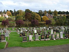 Troqueer Seemetry (Sooth) View fae the upper paith o Troqueer Seemetry (S) across the River Nith
 -
 Fitbrig ower the River Nith Walkwey linkin Castledykes an Troqueer

_-_geograph.org.uk_-_692950.jpg)

References
[eedit | eedit soorce]- ↑ "Welcome to the website of Troqueer Parish Church". Troqueer Parish Church. Archived frae the original on 1 Mairch 2012. Retrieved 13 Februar 2012.
- ↑ Jump up to: a b "Troqueer Kirk Session Minutes". Dumfries and Galloway Community. Dumfries & Galloway Council. Archived frae the original on 17 Januar 2012. Retrieved 13 Februar 2012.
- ↑ Jump up to: a b "Troqueer Kirkcudbrightshire". University of Portsmouth. Retrieved 13 Februar 2012.
- ↑ Jump up to: a b Samuel Lewis (1846). "Troqueer". A TOPOGRAPHICAL DICTIONARY OF SCOTLAND, Published in 2 vols. London.
- ↑ Jump up to: a b Breeze, Andrew (2000). "Four Brittonic Place-Names from South-West Scotland: Tradunnock, Trailflat, Troqueer and Troax" (PDF). Transactions and Journal of Proceedings of the Dumfriesshire and Galloway Natural History and Antiquarian Society. Third Series. LXXIV: 58. Archived frae the original (PDF) on 2 Apryle 2015.
- ↑ James, Alan G. (2014). The Brittonic Language in the Old North: A Guide to the Place-Name Evidence (PDF). Volume 2: Guide to the Elements. p. 381. Archived frae the original (PDF) on 11 September 2014.
- ↑ "Picts Knowe,fort (SM1092)". portal.historicenvironment.scot (in Inglis). Archived frae the original on 20 November 2018. Retrieved 17 November 2019.
- ↑ "Curriestanes,cursus E of (SM5738)". portal.historicenvironment.scot. Archived frae the original on 3 November 2018. Retrieved 17 November 2019.
- ↑ Howie, John (1853). "John Blackadder". The Scots worthies. W.R. M'Phun.CS1 maint: ref=harv (link)
- ↑ "The Burgh of Maxwelltown". Future Museum. Archived frae the original on 28 Januar 2010. Retrieved 13 Februar 2012.
- ↑ "Troqueer Primary School". Dumfries and Galloway Council. Archived frae the original on 5 Mairch 2016. Retrieved 1 Februar 2012.
- ↑ "Featured Architectural Design Projects". Dumfries and Galloway Council. Retrieved 1 Februar 2012.[deid airtin]
- ↑ "Troqueer Community Centre". Dumfries and Galloway Council. Archived frae the original on 5 Mairch 2016. Retrieved 13 Februar 2012.
- ↑ "TROQUEER PARISH CHURCH, DUMFRIES – 12 February 2012" (PDF). Troqueer Parish Church. Retrieved 13 Februar 2012.[deid airtin]
| Wikimedia Commons haes media relatit tae Troqueer. |