Municipality o Tolmin
Municipality o Tolmin Občina Tolmin | |
|---|---|
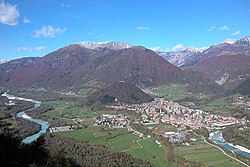
 Tolmin, the centre o the municipality | |
| Coordinates: 46°11′4″N 13°43′59″E / 46.18444°N 13.73306°ECoordinates: 46°11′4″N 13°43′59″E / 46.18444°N 13.73306°E | |
| Kintra | |
| Govrenment | |
| • Mayor | Uroš Brežan |
| Area | |
| • Total | 381.5 km2 (147.3 sq mi) |
| Population (2002)[1] | |
| • Total | 12,198 |
| • Density | 32/km2 (83/sq mi) |
| Time zone | UTC+01 (CET) |
| • Summer (DST) | UTC+02 (CEST) |
| Website | www |
The Municipality o Tolmin (Slovene: Občina Tolmin) is a municipality in northwastren Slovenie. Its centre an the lairgest dounset is Tolmin.
History
[eedit | eedit soorce]In auncient times the aurie wis inhabitit bi the Illyries an then bi the Romans. In the 6t hunderyear the Slavs, ancestors o present-day Slovenes, settled the area.
Tiil 1420 it belangit tae the Patriairchate o Aquileia, when it was acquired bi the Republic o Venice. In 1514 it became a possession of the Habsburgs, who gae it as fief tae the Coronini-Cronberg faimily. Medieval documents testifee tae a lang series o uprisins, culminatin in the Tolmin peasant revolt o 1713. That pairticular insurgence spread frae Tolmin Coonty tae the Vipava Valley, Karst, an Brda, an further on tae northren Istrie. The uprisin was mercilessly crushed bi the imperial airmy an its eleiven leaders wur beheidit.
In the 16t hunderyear, the aurie became pairt o the Coonty o Gorizia an Gradisca. Durin the Warld War I, Tolmin servit as a base for the victorious breach o the Soča/Isonzo Front. Occupee'd bi Italian troops at the end o 1918, it wis pairt o the Kinrick o Italy atween 1918 an 1943 (nominally tae 1947) as a commune o the Province o Gorizia (as Tolmino), except durin the period atween 1924 an 1927, when the Province o Gorizia wis abolished an annexed tae the Province o Udine.[2] an atween 1943 an 1945 o the Nazi German Operational Zone Adriatic Coast. In 1945 it wis leeberatit bi the Yugoslav Pairtisans an in 1947 it wis offeecially annexed tae Yugoslavie. Syne then, it haes been a integral pairt o Slovenie.
Geografie
[eedit | eedit soorce]The Tolmin aurie includes the Tolminka an Zadlaščica basins at the entrance tae Triglav Naitional Pairk, which are its lawest point (180 m) an aw. A special featur o the Tolminka Basins is a thermal spring at the end o the path. The region boasts several record-hauldin watterfaws (Brinta Falls 104 m, Gregorčič Falls 88 m) an aw an several ither smawer watterfaws hidden in the ravines o Cauld Creek (Slovene: Mrzli potok), Godiča Creek, Pščak Creek, an Sopotnica Creek.
Cultur
[eedit | eedit soorce]Tolmin haes been the venue for the Metaldays hivy metal festival an Soča Reggae Riversplash festival.
Politics
[eedit | eedit soorce]The Municipality o Tolmin is govrened bi a mayor electit ivery fower years bi popular vote, an a municipal cooncil o 22 members. The local poleetical scene is relatively diversifeee'd, wi nae prevalence o a pairticular pairty, awtho the conservative New Slovenie an Slovenie Fowkpairty tend tae receive a heicher proportion o votes than their naitional average. Tradeetionally, the left-wing an leeberal pairties hae been stranger in the toun center, whauras the kintraside tends tae favor conservative pairties. In naitional politics, the Tolmin electoral destrict haes heichly favored the conservative Slovenie Democratic Pairty, but this is lairgely due tae the prevalence o this pairty in the ither twa municipalities shapin the destrict, (Bovec an Kobarid).
References
[eedit | eedit soorce]- ↑ Statistical Office of the Republic of Slovenia, census of 2002
- ↑ http://utenti.multimania.it/Legionario/vgammin.htm Archived 2011-07-19 at the Wayback Machine Tolmin was during Italian Rule
| Wikimedia Commons haes media relatit tae Municipality o Tolmin. |
