Municipality o Črna na Koroškem
Municipality o Črna na Koroškem Občina Črna na Koroškem | |
|---|---|
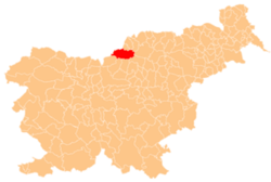
 Location o the Municipality o Črna na Koroškem in Slovenie | |
| Coordinates: 46°28′N 14°51′E / 46.467°N 14.850°ECoordinates: 46°28′N 14°51′E / 46.467°N 14.850°E | |
| Kintra | |
| Govrenment | |
| • Mayor | Janez Švab |
| Area | |
| • Total | 156.0 km2 (60.2 sq mi) |
| Population (2002)[1] | |
| • Total | 3,616 |
| • Density | 23/km2 (60/sq mi) |
| Time zone | UTC+01 (CET) |
| • Summer (DST) | UTC+02 (CEST) |
The Municipality of Črna na Koroškem (Slovene: Občina Črna na Koroškem) is a municipality in northren Slovenie. The seat o the municipality is the toun o Črna na Koroškem. It lees in the tradeetional Slovenie province o Carinthie,[2] close tae the border wi Austrick. Syne 2005 it haes been pairt o the lairger Carinthie Statistical Region.
Geografie
[eedit | eedit soorce]The municipal aurie stretches alang the upper Meža Valley at the confluence o the Meža River wi its tributar Javorje Creek (Slovene: Javorski potok). The surroondin muntains o the Karawanks an Kamnik–Savinja Alps ranges include the Peca massif at the Austrian border in the northwast, wi the summit o Kordež Head (Slovene: Kordeževa glava) reachin a elevation o 2,126 m (6,975 ft). Due tae its picturesque settin, the municipality is a popular destination for muntain hikers.
References
[eedit | eedit soorce]- ↑ "Statistical Office of the Republic of Slovenia, census of 2002". Archived frae the original on 18 December 2016. Retrieved 6 November 2014.
- ↑ "Črna na Koroškem municipal site". Archived frae the original on 9 October 2011. Retrieved 6 November 2014.
Freemit airtins
[eedit | eedit soorce] Media relatit tae Municipality of Črna na Koroškem at Wikimedia Commons
- Municipality of Črna na Koroškem on Geopedia Archived 2017-07-29 at the Wayback Machine
