Mondulkiri Province
Mondulkiri មណ្ឌលគិរី | |
|---|---|
 Tourists at Bou Sra Watterfaw. | |
 Map o Cambodie heichlichtin Mondulkiri | |
| Coordinates: 12°27′N 107°14′E / 12.450°N 107.233°E | |
| Kintra | |
| Caipital | Sen Monorom |
| Area | |
| • Total | 14288 km2 (5,517 sq mi) |
| Population (2008)[1] | |
| • Total | 60,811 |
| • Density | 4.3/km2 (11/sq mi) |
| Time zone | UTC+07 |
| Dialin code | +855 |
| ISO 3166 code | KH-11 |
| Destricts | 5 |
| Communes | 21 |
| Veelages | 98 |
Mondulkiri (Khmer: មណ្ឌលគិរី, IPA: [mɔn ˌdɔːl ki ˈriː] literally: "Muntain o the Mandala.") is a province (khaet) o Cambodie. Bordering the provinces o Kratie tae the wast, Stung Treng tae the northwast, Ratanakiri tae the north an the kintra o Vietnam tae the east an sooth, it is the maist spairsely populatit province in the kintra despite being the lairgest in land aurie. The caipital is the toun o Senmonorom.
Geografie an environment
[eedit | eedit soorce]
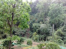
Mondulkiri is kent for its forestit hills an pouerful watterfaws. Some watterfaws include:
- Bou Sra Watterfaw. Locatit at Pich Chinda Destrict, 43 kilometers frae Senmonorom toun, Bou Sra is the lairgest watterfaw, made famous bi a popular Khmer sang in Mondulkiri.
- Senmonorom Watterfaw. Five kilometers frae toun an an easy walk, Senmonorom watterfaw is no hintle tae leuk at an uised tae be a nice picnic spot till the construction o a Japanese built hydro electric pouer station that cut the flow o watter.
- Romnea Watterfaw. Ten kilometers frae Senmonorom, Romnea watterfaw is actually 1 o 3 lairge watterfaws that haes nou been deforestit an privatisit.
Mondulkiri faces a significant threat frae illegal loggers attemptin tae exploit the aurie's virgin forests.[2]
Destricts
[eedit | eedit soorce]The province is subdividit intae 5 destricts, which are further subdivided into 21 communes and 98 villages.
- 1101 Keo Seima - កែវសីម៉ា
- 1102 Kaoh Neak - កោះញែក
- 1103 O Reang - អូររាំង
- 1104 Pech Chenda - ពេជ្រាដា
- 1105 Senmonorom - សែនមនោរម្យ
Demografics
[eedit | eedit soorce]Aichty percent o Mondulkiri's population is made up o ten tribal minorities, wi the majority o them being Pnong. The remainin 20 percent are Khmer, Cheenese, an Muslims Cham.
Economy an transportation
[eedit | eedit soorce]The population lives aff the land, plantin rice, fruit trees, an a variety o vegetables. Ithers grow strawberries, coffee, rubber, an cashew nuts.
Road development continues tae impact seriously on indigenous commonties like the Pnong ethnic group. Accordin tae a Unitit Naitions paper, the construction o a road frae Mondulkiri tae Ratanakiri haes resultit in massive land grabbin.[3]
Cultur
[eedit | eedit soorce]Although mair an mair hooses are built in 'Khmer style', traditional Phnong hooses can still be foond. Pnong hooses contain lairge jars (which are said tae be mair nor a thoosan year auld) an traditional gongs. Thare are various gongs uised at different occasions. Jars an gongs are amang the maist valuable possessions o indigenous commonties baith in traditional an spiritual as well as material terms. Durin the times o Pol Pot those objects wur buriet in hidden places in the jungle an in mony cases they still wait in the grund.
Location
[eedit | eedit soorce]References
[eedit | eedit soorce]| Wikimedia Commons haes media relatit tae Mondul Kiri. |
- ↑ "General Population Census of Cambodia 2008 - Provisional population totals" (PDF). National Institute of Statistics, Ministry of Planning. 3 September 2008.
- ↑ Illegal Logging in Mondulkiri – a Test Case for Forest Sector Law Enforcement, Global Witness.
- ↑ Permanent Forum on Indigenous Issues, Economic and Social Council, United Nations.
