Holguín
Holguín | |
|---|---|
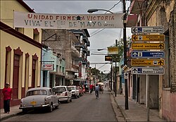
 Vikas Street in Holguín | |
Location o Holguín in Cuba | |
| Coordinates: 20°53′19″N 76°15′26″W / 20.88861°N 76.25722°WCoordinates: 20°53′19″N 76°15′26″W / 20.88861°N 76.25722°W | |
| Kintra | |
| Province | Holguín |
| Established | 1523[1] |
| Area | |
| • Total | 655.9 km2 (253.2 sq mi) |
| Elevation | 150 m (490 ft) |
| Population (2004)[3] | |
| • Total | 326,740 |
| • Density | 490.6/km2 (1,271/sq mi) |
| Time zone | UTC-5 (EST) |
| Area code(s) | +53-24 |
Holguín (Spaingie pronunciation: [olˈɣin]) is a municipality an ceety, the caipital o the Cuban Province o Holguín. It an aw includes a tourist aurie, afferin beach resorts in the ootskirts o the region.
History
[eedit | eedit soorce]It wis foondit as San Isidoro de Holguín in 1545,[4] an it is namit efter its foonder Caiptain García Holguín, a Spainyie military officer. Afore 1976, Holguín wis locatit in the province o Oriente.
Infrastructure
[eedit | eedit soorce]
Thare are several sma ceety pairks sicna Parque Infantil, Parque San Jose, Parque San Isidoro, Parque Marti amang ithers, maist central the Calixto García in the dountoun aurie. Near aboots ane fynds the galleries Centro Provincial de Arte an Bayado, a library, the club Casa de la Trova, the Martí cinema, the Theatre Eddy Suñol, the Province Museum La Periquera, a science museum, an a history museum. Frae the hill Loma de la Cruz, whaur a lairge crucifix is instawed, that can be ascendit bi its 450 stairs, ane can owersee the hale ceety.
Holguín haes a basebaw stadium. The Frank País Internaitional Airport (ceety code HOG) is connectit tae Havana an several ither warld destinations.
The municipality is dividit intae the barrios o Aguarás, Aguas Claras, Alcalá, Arroyo Blanco del Sur, Báguanos, Cabezuelas, Cacocún, Calderón, Camazán, Cauto del Cristo, Corralillo, Cruces de Purnio, Damián, Floro Pérez, Guabasiabo, Guayabal, Guirabo, Haticos del Purial, La Aguada, La Cuaba, La Palma, La Rioja, Las Calabazas, Managuaco, Melones, Norte, Omaja, Purnio, San Agustín, San Andrés, San Francisco, San Juan, San Lorenzo, Santa Rita, Sur, Tacámara, Tasajeras, Uñas, Uñitas, Velasco, Yareyal an Yayal.[1]
The main seicontary eddication institution is the University o Holguín.
Economy
[eedit | eedit soorce]The brewery Cerveceria Bucanero - a jynt ventur wi Labatt o Canadae - is based in the ceety. It maks three braunds o beer (Bucanero, Cristal an Mayabe) sauld in convertible pesos.
Near Holguín, the Villa El Quinque an the Villa El Cocal are warld-renouned centres for addictions treatment, receivin patients frae aroond the warld. Argentine soccer starn Diego Maradona wis treatit for his cocaine addiction thare. The popular Playa Pesquero (Fishin Boat Beach) is locatit on the coast north o Holguín ceety, aboot an oor's drive frae the Internaitional Airport.
Demographics
[eedit | eedit soorce]In 2004, the municipality o Holguín haed a population o 326,740,[3] makkin it the fowert lairgest ceety in Cuba in terms o population. Wi a total aurie o 666 km2 (257 sq mi)[2] it haes a population densitie o 490.6 /km2 (1,271 /sq mi).
Transportation
[eedit | eedit soorce]Holguín is served bi Frank País Airport (HOG/MUHG), locatit at 20°47´08"N, 076°18´54"W.
Sister ceeties
[eedit | eedit soorce] Etobicoke, Ontario, Canadae
 Santa Fe, New Mexico, USA
 Saltillo, Coahuila, Mexico
 Wast Kanpur, Uttar Pradesh, Indie
References
[eedit | eedit soorce]- ↑ a b Guije.com. "Holguín". Retrieved 5 October 2007. (in Spaingie)
- ↑ a b Statoids. "Municipios of Cuba". Retrieved 5 October 2007.
- ↑ a b Atenas.cu (2004). "2004 Population trends, by Province and Municipality". Archived frae the original on 27 September 2007. Retrieved 5 October 2007. (in Spaingie)
- ↑ Guije.com (2004). "Ciudad de Holguin". Retrieved 17 Februar 2007. Unknown parameter
|month=ignored (help)
Freemit airtins
[eedit | eedit soorce]- (in Spaingie) Holguín Wab portal Archived 2018-08-31 at the Wayback Machine
- Inglis-leid ceety guide
- Holguin beaches guide Archived 2010-03-29 at the Wayback Machine
- Holguin Cuba (in Inglis) (in French)
- Cuba Holguin
| This North Americae-relatit airticle is a stub. Ye can help Wikipaedia bi expandin it. |
| This ceity-relatit airticle is a stub. Ye can help Wikipaedia bi expandin it. |

