Columbia River
Appearance
| Columbia River | |
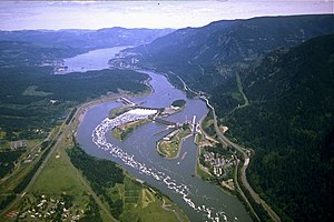
Bonneville Dam, in the Columbia River Gorge
| |
| Name oreegin: Captain Robert Gray's ship, Columbia Rediviva | |
| Nickname: Big River, the River o the Wast, River Oregon[1] | |
| Kintras | Unitit States, Canadae |
|---|---|
| States | Washington, Oregon |
| Province | Breetish Columbie |
| Tributaries | |
| - left | Spillimacheen River, Beaver River, Illecillewaet River, Incomappleux River, Kootenay River, Pend Oreille River, Spokane River, Snake River, John Day River, Deschutes River, Willamette River |
| - right | Kicking Horse River, Blaeberry River, Canoe River, Kettle River, Sanpoil River, Okanogan River, Entiat River, Wenatchee River, Yakima River, Lewis River, Cowlitz River |
| Ceeties | Revelstoke, BC, Wenatchee, WA, East Wenatchee, WA, Tri-Cities, WA, The Dalles, OR, Hood River, OR, Portland, OR, Vancouver, WA, Longview, WA, Astoria, OR |
| Soorce | Columbia Lake |
| - location | British Columbia, Canada |
| - elevation | 2,690 ft (820 m) [2] |
| - coordinates | 50°13′35″N 115°51′05″W / 50.22639°N 115.85139°W [3] |
| Mooth | Paceefic Ocean, at Clatsop County, Oregon / Pacific County, Washington |
| - elevation | 0 ft (0 m) |
| - coordinates | 46°14′39″N 124°3′29″W / 46.24417°N 124.05806°WCoordinates: 46°14′39″N 124°3′29″W / 46.24417°N 124.05806°W [4] |
| Lenth | 1,243 mi (2,000 km) [5] |
| Basin | 258,000 sq mi (668,000 km2) |
| Discharge | for mouth (average); max and min at The Dalles, Oregon, 188.9 mile (304.0 km) from the mouth |
| - average | 265,000 cu ft/s (7,500 m3/s) [6] [7][8] |
| - max | 1,240,000 cu ft/s (35,100 m3/s) |
| - min | 12,100 cu ft/s (300 m3/s) |
Columbia River drainage basin
| |
| Wikimedia Commons: Columbia River | |
The Columbia River is the lairgest river in the Paceefic Northwast region o North Americae.
References
[eedit | eedit soorce]- ↑ Holbrook, Stewart (1956). The Columbia. San Francisco: Comstock Editions. ISBN 978-0-89174-051-3.
- ↑ Marsh, James H. (2013). "Columbia River". The Canadian Encyclopedia. Historica Foundation. Retrieved 30 September 2015.
- ↑ "Columbia Lake". Canadian Geographical Names Data Base. Natural Resources Canada. 2015. Retrieved 29 September 2015.
- ↑ "Columbia River". Geographic Names Information System. United States Geological Survey. 28 November 1980. Archived frae the original on 22 Juin 2020. Retrieved 1 Apryle 2008.
- ↑ "The Columbia River". Columbia River Keeper. 2013. Archived frae the original on 7 Januar 2019. Retrieved 5 December 2013.
- ↑ Kammerer, J. C. (Mey 1990). "Largest Rivers in the United States". United States Geological Survey. Archived frae the original on 29 Januar 2017. Retrieved 1 Apryle 2008. Unknown parameter
|dead-url=ignored (help) - ↑ Kimbrough, R. A.; Ruppert, G. P.; Wiggins, W. D.; Smith, R. R.; Kresch, D. L. (2006). "Water Data Report WA-05-1: Klickitat and White Salmon River Basins and the Columbia River from Kennewick to Bonneville Dam" (PDF). Water Resources Data-Washington Water Year 2005. United States Geological Survey. Retrieved 1 Apryle 2008.
- ↑ Loy et al. 2001, pp. 164–65.


