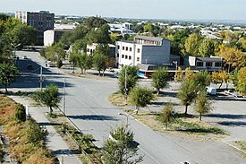
Artashat
Artashat Արտաշատ | |
|---|---|
 Modren Artashat | |
| Coordinates: 39°57′14″N 44°33′02″E / 39.95389°N 44.55056°E | |
| Kintra | |
| Marz | Ararat |
| Foondit | 176 B.C.[1] |
| Govrenment | |
| • Mayor | Gagik Muradyan |
| Area | |
| • Total | 10 km2 (4 sq mi) |
| Elevation | 2000 m (7,000 ft) |
| Population | |
| • Total | 25,300 |
| • Density | 2530/km2 (6,600/sq mi) |
| Time zone | UTC+4 (GMT+4) |
| • Summer (DST) | UTC+5 (GMT+5) |
| Website | Artashat official website |
| Sources: Population [2] | |
Artashat (Armenie: Արտաշատ; Hellenisit as Artaxata: Greek: Ἀρτάξατα), is a ceety on Araks River in the Ararat valley, 30 km sootheast o Yerevan. Being ane o the auldest ceeties o Armenie, Artashat is the caipital o Ararat Province. Modren Artashat is situatit on the Yerevan-Nakhichevan-Baku an Nakhichevan-Tabriz railwa an on Yerevan-Goris-Stepanakert heich-gate. The name o the ceety is derived frae Iranian leids an means the "joy o Arta".[1][3] Foondit bi King Artashes I in 176 B.C., Artashat servit as the caipital o the Kinrick o Armenie frae 185 BC till 120 AD, an wis kent as the Vostan Hayots, the "court" or "seat o the Armenies."[1]
Present-day Artashat is a mid-sizit ceety an haes a population o 25,300 fowk. It is locatit 5 km northwast frae historical Artashat.
Sister ceeties
[eedit | eedit soorce]Gallery
[eedit | eedit soorce]- Artashat
-
Dountoun Artashat
-
Apricot gardens in Artashat
-
Auncient bath in Artashat
See an aw
[eedit | eedit soorce]References
[eedit | eedit soorce]- ↑ a b c Hewsen, Robert H. Artaxata. Iranica. Accessed February 25, 2008.
- ↑ Armstats:Population
- ↑ (in Armenie) Tiratsyan, Gevorg. «Արտաշատ» (Artashat). Armenian Soviet Encyclopedia. vol. ii. Yerevan: Armenian Academy of Sciences, 1976, pp. 135-136.
- ↑ Artashat urban community[deid airtin]


