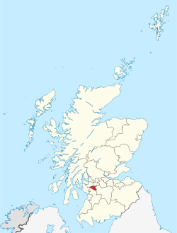
East Renfrewshire
East Renfrewshire Siorrachd Rinn Friù an Ear | |
|---|---|
 | |
| Coordinates: 55°47′54″N 4°17′27″W / 55.7984°N 4.2907°WCoordinates: 55°47′54″N 4°17′27″W / 55.7984°N 4.2907°W | |
| Admin HQ | Giffnock |
| Govrenment | |
| • Bodi | East Renfrewshire Cooncil |
| • Control | SNP + Lab + Ind (cooncil NOC) |
| • MPs | Paul Masterton (Conservative – East Renfrewshire) |
| • MSPs | • Jackson Carlaw (Conservative – Eastwood) • Tom Arthur (SNP – Renfrewshire Sooth) |
| Area | |
| • Total | 174.3 km2 (67.3 sq mi) |
| Area rank | Ranked 28th |
| Population (mid-2016 est.) | |
| • Total | 93,800 |
| • Rank | Rankit 23rd |
| • Density | 538/km2 (1,390/sq mi) |
| ONS code | S12000011 |
| ISO 3166 code | GB-ERW |
| Website | http://www.eastrenfrewshire.gov.uk/ |
East Renfrewshire (spelt Eist Renfrewshire or Aest Renfrewshire anaw) is ane o the 32 cooncil areas o Scotland. It is 174 square kilometer in area an haes 89,500 indwallers as o 2005.
The cooncil area wis shapit in 1996, as an eftirganger til the Eistwid destrik, alang wi Barrheid, whilk cam frae Renfrew destrik. It haes mairches wi North Ayrshire, East Ayrshire, Renfrewshire, Sooth Lanrikshire an the Ceitie o Glesga.
Sattilments
[eedit | eedit soorce]The touns in Eist Renfrewshire ar Barrheid (19,813 fowk), Clarkston (4,778 fowk), Giffnock (9,353 fowk) an Newton Mearns (22,637 fowk).
Thar is a nummer o veilages in Eist Renfreshire anaw, thay'r cried Busby, Eaglesham (3,127 fowk), Neilston (5,168 fowk), Uplawmuir (590 fowk) an Watterfit (1,279 fowk). Ither sattilments ar Cauldwall, pairts o Muirend, Netherlee (4,741 fowk), Stamperland an Thornliebank.
| Wikimedia Commons haes media relatit tae East Renfrewshire. |
| This Scotland-relatit airticle is a stub. Ye can help Wikipaedia bi expandin it. |
| This Places o Scotland airticle is a stub. Ye can help Wikipaedia bi expandin it. |
