Wakayama Prefectur
Appearance
Wakayama Prefecture 和歌山県 | |
|---|---|
| Japanese transcription(s) | |
| • Japanese | 和歌山県 |
| • Rōmaji | Wakayama-ken |
 | |
| Kintra | Japan |
| Region | Kansai |
| Island | Honshū |
| Caipital | Wakayama |
| Govrenment | |
| • Govrenor | Yoshinobu Nisaka |
| Area | |
| • Total | 4,725.67 km2 (1,824.59 sq mi) |
| Area rank | 30th |
| Population (Aprile 1, 2012) | |
| • Total | 989,983 |
| • Rank | 39t |
| • Density | 209.49/km2 (542.6/sq mi) |
| ISO 3166 code | JP-30 |
| Destricts | 6 |
| Municipalities | 30 |
| Flouer | Ume blossom (Prunus mume) |
| Tree | Ubame aik (Quercus phillyraeoides) |
| Bird | Japanese white-eye (Zosterops japonica) |
| Website | www.wakayama.lg.jp/ english/ |
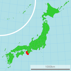
Wakayama Prefectur (和歌山県 Wakayama-ken) is a prefectur o Japan locatit on the Kii Peninsula in the Kansai region on Honshū island.[1] The caipital is the ceety o Wakayama.[2]
References
[eedit | eedit soorce]- ↑ Nussbaum, Louis-Frédéric. (2005). "Wakayama prefecture" in Japan Encyclopedia, p. 1026 at Google Books; "Kansai" in p. 477 at Google Books.
- ↑ Nussbaum, "Wakayama" in p. 1025 at Google Books.


