Kanagawa Prefectur
Appearance
Kanagawa Prefecture 神奈川県 | |
|---|---|
| Japanese transcription(s) | |
| • Japanese | 神奈川県 |
| • Rōmaji | Kanagawa-ken |
 | |
| Coordinates: 35°26′51.03″N 139°38′32.44″E / 35.4475083°N 139.6423444°ECoordinates: 35°26′51.03″N 139°38′32.44″E / 35.4475083°N 139.6423444°E | |
| Kintra | Japan |
| Region | Kantō |
| Island | Honshu |
| Caipital | Yokohama |
| Govrenment | |
| • Govrenor | Yuji Kuroiwa (syne Aprile 2011) |
| Area | |
| • Total | 2,415.84 km2 (932.76 sq mi) |
| Area rank | 43rd |
| Population (1 September 2010) | |
| • Total | 9,029,996 |
| • Rank | 2nd |
| • Density | 3740/km2 (9,700/sq mi) |
| ISO 3166 code | JP-14 |
| Destricts | 6 |
| Municipalities | 33 |
| Flouer | Golden-rayed lily (Lilium auratum) |
| Tree | Ginkgo (Ginkgo biloba) |
| Bird | Common gull (Larus canus) |
| Website | www.pref.kanagawa.jp/ |

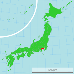
Kanagawa Prefectur (神奈川県 Kanagawa-ken) is a prefectur locatit in the soothren Kantō region o Japan.[1] The caipital is Yokohama.[2] Kanagawa is pairt o the Greater Tokyo Aurie.
Notes
[eedit | eedit soorce]- ↑ Nussbaum, Louis-Frédéric. (2005). "Kanagawa" in Japan Encyclopedia, p. 466 at Google Books; "Kantō" in p. 479 at Google Books.
- ↑ Nussbaum, "Yokohama" in pp. 1054-1055 at Google Books.
Freemit airtins
[eedit | eedit soorce]![]() Media relatit tae Kanagawa prefecture at Wikimedia Commons
Media relatit tae Kanagawa prefecture at Wikimedia Commons
- Offeecial Kanagawa Prefectur wabsteid Archived 2012-01-20 at the Wayback Machine
- Official Kanagawa Living website Archived 2009-11-24 at the Wayback Machine
- Kanagawa Prefectural Tourist Association website Archived 2012-02-04 at the Wayback Machine (Inglis)


